Location
Latitude: |
35-05-40.6000N (35.094611) |
Longitude: |
106-09-52.4000W (-106.164556) |
Elevation: |
6565.0 feet MSL (2001 m MSL) |
Magnetic Variation: |
7.7 E (as of April 2024 from WMM2020 model) |
Time Zone: |
UTC -7.0 (Standard Time) UTC -6.0 (Daylight Savings Time) |
From City: |
02 N.M. NE of Edgewood, New Mexico |
Found On: |
Albuquerque Chart |
FAA Region: |
ASW |
Contacts
Manager: |
Privately owned: |
| KAY TANIS 71 RAINBOW ROAD EDGEWOOD, NM 87015 505-263-3759 |
SANDIA AIRPARK INC 71 RAINBOW ROAD EDGEWOOD, NM 87015 505-281-0322 |
Operations
Airport Status: |
Operational |
Facility Use: |
Public |
Type: |
Airport |
Activation Date: |
12/1985 |
Control tower: |
No |
Attendance (Months/Days/Hours): |
Months/Days/Hours ALL/TUE-SAT/0900-1400 |
Boundary ARTCC: |
ZAB (Albuquerque) |
Responsible ARTCC: |
ZAB (Albuquerque) |
Lighting Schedule: |
SEE RMK |
Traffic Pattern Altitude (MSL): |
7565 feet (2306 m) |
NOTAMs Facility: |
ABQ |
NOTAM-D Service: |
Yes |
Based Aircraft
| Single Engine: | 69 |
| Multi Engine: | 2 |
| GA Helicopters: | 1 |
| Ultralights: | 5 |
Annual Operations (as of 04/03/2021)
| Total Operations: | 6500 | |
| GA Local: | 3500 | 53.8% |
| GA Itinerant: | 3000 | 46.2% |
Communications
| CTAF: | 122.800 |
| Unicom: | 122.800 |
Fixed Based Operators (FBOs) & Fuel
(Click on a business for detail)
Please help us keep this information up to date. This is a FREE SERVICE just like everything else on Airport Guide! If you see that a business needs to be added, modified, or deleted please fill out our Update Form.
To add, modify, or delete a business click here.
Please help us keep this information up to date. This is a FREE SERVICE just like everything else on Airport Guide! If you see that a business needs to be added, modified, or deleted please fill out our Update Form.
Area Code: 505 |
| Business Name | Frequency | Phone | Fuel Grade |
|---|---|---|---|
| Air-Tec
Update FBO info |
Unicom 122.8 | 281-3364 | 100LL, Mogas |
Flight Service Stations
| Primary | Alternate | |
| FSS on Field: | N | |
| FSS Name (ID): | Albuquerque(ABQ) | |
| Frequency: | ||
| Toll Free Phone: | 1-800-WX-BRIEF |
Instrument Procedures / Charts
Terminal Procedures are only available for airports in several countries with more being added all the time. If you are looking for a specific country's charts, please send an email to support(at)airportguide.com stating the country name. This will be used to prioritize the implementation.
Navigation Aids (Navaids) near 1N1
| Dist (NM) | ID | Morse Code | Name | Type | Freq | True Hdg | Mag Hdg |
|---|---|---|---|---|---|---|---|
| 11.3 | OTO | _ _ _ _ _ _ _ | Otto | VOR | 114.00 | 96 | 88 |
| 22.1 | ABQ | . _ _ . . . _ _ . _ | Albuquerque | VOT | 111.00 | 261 | 253 |
| 27.2 | SAF | . . . . _ . . _ . | Santa Fe | VORTAC | 110.60 | 10 | 2 |
| 27.7 | SG | . . . _ _ . | Doman | NDB | 341 | 2 | 354 |
| 27.9 | AE | . _ . | Dudle | NDB | 351 | 285 | 277 |
| 32.2 | ABQ | . _ _ . . . _ _ . _ | Albuquerque | VORTAC | 113.20 | 264 | 256 |
| 42.4 | BRG | _ . . . . _ . _ _ . | Belen | DME | 114.75 | 231 | 223 |
| 49.8 | CNX | _ . _ . _ . _ . . _ | Corona | VORTAC | 115.50 | 151 | 143 |
| 55.2 | ACH | . _ _ . _ . . . . . | Anton Chico | VORTAC | 117.80 | 88 | 81 |
| 55.7 | ONM | _ _ _ _ . _ _ | Socorro | VORTAC | 116.80 | 215 | 207 |
| 60.6 | FTI | . . _ . _ . . | Fort Union | VORTAC | 117.30 | 55 | 48 |
| 91.7 | TAS | _ . _ . . . | Taos | VORTAC | 115.80 | 7 | 359 |
Nearby Airports with Fuel
| Dist (NM) | Name (Airport IDs) | True Hdg | Mag Hdg | Fuel Grade |
|---|---|---|---|---|
| 10.7 | Moriarty Municipal Airport (0E0) |
130 | 122 | 100LL, Jet A |
| 22.0 | Albuquerque International Sunport Airport (ABQ KABQ ABQ) |
261 | 253 | 100LL, Jet A, Jet A-1, Jet A-1+ |
| 31.1 | Double Eagle Ii Airport (KAEG AEG) |
275 | 267 | 100LL, Jet A-1 |
| 31.6 | Santa Fe Regional Airport (SAF KSAF SAF) |
6 | 358 | 100LL, Jet A, Jet A+ |
| 34.9 | Mid Valley Airpark Airport (E98) |
235 | 227 | 100LL |
| 42.6 | Belen Regional Airport (BRG) |
231 | 223 | 100LL, Jet A-1+ |
| 47.4 | Los Alamos Airport (LAM KLAM LAM) |
353 | 345 | 100LL |
| 60.2 | Las Vegas Municipal Airport (LVS KLVS LVS) |
55 | 48 | 100LL, Jet A-1 |
| 74.0 | Socorro Municipal Airport (ONM KONM ONM) |
209 | 201 | 100LL |
| 75.4 | Santa Rosa Route 66 Airport (KSXU SXU) |
96 | 89 | 100LL, Jet A |
| 84.9 | Taos Regional Airport (TSM KSKX SKX) |
16 | 8 | 100LL, Jet A-1+ |
| 85.4 | Grants-Milan Municipal Airport (GNT KGNT GNT) |
273 | 265 | 100LL, Jet A-1+ |
| 87.8 | Carrizozo Municipal Airport (F37) |
171 | 164 | 100LL |
| 90.3 | Angel Fire Airport (AXX KAXX AXX) |
27 | 20 | 100LL, Jet A+ |
Notices to Airmen (NOTAMS)
Remarks
| A110-1 | WILDLIFE ON OR IN VICINITY OF AIRPORT |
| A110-2 | EMERGENCY PHONE: 505-281-5717 (POLICE) OR 505-281-4697 (FIRE DEPT.) |
| A110-3 | FOR CD CTC ALBUQUERQUE ARTCC AT 505-856-4861. |
| A16 | ADDITIONAL CONTACT 505-281-0322. |
| A40-09/27 | NSTD LIRL RWY 9-27 IRREGULAR SPACING, COLOR, SINGLE FIXTURE ON RWY 9 THLD, NO THLD LIGHTS RWY 27, SEVERAL FIXTURES MISSING OR INOPERATIVE. |
| A42-09 | CENTERLINE FADED AND PORTIONS MISSING. |
| A42-27 | CENTERLINE FADED AND PORTIONS MISSING. |
| A58-09 | RWY 9 +3 FT STOP SIGN, +4' BUSHES 10 FT FROM THRESHOLD, 88 FT RIGHT OF CENTERLINE, +12 FT BUSHES 10 FT FROM THRESHOLD, 108 FT RIGHT OF CENTERLINE. |
| A58-27 | RWY 27 +5 FT FENCE 185 FT FM RWY END 32 FT LEFT; +4 FT SIGN 185 FT FM THLD, 85 FT RIGHT; -2 FT CULVERT 108 FT FM THLD, 45 FT LEFT OF CTRLN. |
| A70-FUEL-10 | 0LL SELF SERVICE FUEL WITH CREDIT CARD. |
| A72 | AIRTEC, INC. 505-281-3364. |
| A81-APT | ACTVT NSTD LIRL RWY 09/27 - CTAF (5 CLICKS). |
| A81-BCN | OTS INDEF. |
| A82 | AUTOMATED UNICOM; 3 CLICKS WIND ADZY; 4 CLICKS FOR ALL OTHER ADZY INFO. |
| A83 | AUX WIND SOCK NEAR RWY 9 THLD ILLUMINATED WITH SOLAR POWER. |
Runways
Runway Summary
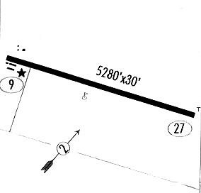
| Runways: | 09/27 |
| Longest Runway: | 09/27 is 4830 ft (1472 m) long |
| Runways with an Instrument Approach: |
1N1 Airport Runway Details
| Runway 09/27 | 4830 ft x 30 ft (1472 m x 9 m) | |
| Surface: | Asphalt - Fair condition - No special surface treatment | |
| Runway Edge Lights: | Non-standard lighting system Intensity | |
Runway 09 |
Runway 27 |
|
Elevation: |
6565.0 | 6515.0 |
Latitude: |
35-05-40.5558N | 35-05-40.6020N |
Longitude: |
106-10-21.4974W | 106-09-23.3592W |
|
Runway True Alignment: |
090 | 270 |
Glide Path Angle: |
0.0 degrees | 0.0 degrees |
Traffic Pattern: |
Left | |
Runway Markings Type: |
Basic | Basic |
Runway Markings Condition: |
Poor | Poor |
Object at End: |
BLDG | |
Object Height: |
14 | |
Distance from End: |
400 | |
Object Centerline Offset: |
140 ft. right of centerline |
Services
Fuel Available: |
100LL, Jet A+ |
Landing Fees: |
No |
Parking: |
Hangars and tiedowns available |
Maps & Diagrams
1N1 Sectional
Flight Planning
at skyvector.com
at skyvector.com