Location
Latitude: |
59-01-04.1900N (59.017831) |
Longitude: |
161-49-37.8900W (-161.827192) |
Elevation: |
18.0 feet MSL (5 m MSL) |
Magnetic Variation: |
9.8 E (as of May 2024 from WMM2020 model) |
Time Zone: |
UTC -9.0 (Standard Time) UTC -8.0 (Daylight Savings Time) |
From City: |
00 N.M. W of Platinum, Alaska |
Found On: |
Kodiak Chart |
FAA Region: |
AAL |
Contacts
Manager: |
Publicly owned: |
| JOSEPH LARAUX BOX 505 BETHEL, AK 99559 (907) 543-2498 |
ALASKA DOT&PF CENTRAL REGION P.O. BOX 196900 ANCHORAGE, AK 99519-6900 (907) 269-0749 |
Operations
Airport Status: |
Operational |
Facility Use: |
Public |
Type: |
Airport |
Activation Date: |
08/1947 |
Control tower: |
No |
Attendance (Months/Days/Hours): |
Months/Days/Hours Unattended |
Boundary ARTCC: |
ZAN (Anchorage) |
Responsible ARTCC: |
ZAN (Anchorage) |
Lighting Schedule: |
SEE RMK |
Segmented Circle Indicator: |
Yes |
Traffic Pattern Altitude (MSL): |
1018 feet (310 m) |
NOTAMs Facility: |
PTU |
NOTAM-D Service: |
Yes |
International Airport of Entry: |
No |
Customs Landing Rights: |
No |
Military Landing Rights: |
Yes |
Civil/Military Joint Use: |
No |
Based Aircraft
Annual Operations (as of 12/31/2022)
| Total Operations: | 500 | |
| Air Taxi: | 500 | 100.0% |
Communications
| CTAF: | 122.800 |
| Unicom: | 122.800 |
| AWOS-3P: | 118.375 (907-979-8800) |
- APCH/DEP SVC PRVDD BY ANCHORAGE ARTCC ON FREQS 124.2/251.1 (CAPE NEWENHAM RCAG).
Fixed Based Operators (FBOs) & Fuel
(Click on a business for detail)
Please help us keep this information up to date. This is a FREE SERVICE just like everything else on Airport Guide! If you see that a business needs to be added, modified, or deleted please fill out our Update Form.
To add, modify, or delete a business click here.
Please help us keep this information up to date. This is a FREE SERVICE just like everything else on Airport Guide! If you see that a business needs to be added, modified, or deleted please fill out our Update Form.
Area Code: 907 |
| Business Name | Frequency | Phone | Fuel Grade |
|---|
Flight Service Stations
| Primary | Alternate | |
| FSS on Field: | N | |
| FSS Name (ID): | Kenai(ENA) | |
| Frequency: | ||
| Toll Free Phone: | 1-866-864-1737 |
Instrument Procedures / Charts
FAA Terminal Procedures valid from 0901Z 03/21/24 to 0901Z 04/18/24.
There are various types of charts available for an airport. They are listed in the Page Type column. Here is a legend for those types:
APD - Airport Diagram
DP - Departure Procedure Charts
HOT - Hot Spots
IAP - Instrument Approach Procedure Charts
MIN - Minimums
STAR - Standard Terminal Arrival Charts
| Page Type | Page Name | Volume | Action Since Last Cycle |
|---|---|---|---|
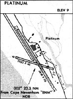
| IAP | RNAV (GPS) RWY 14 | AK-1 | |
| MIN | ALTERNATE MINIMUMS | AK-1 | |
| MIN | TAKEOFF MINIMUMS | AK-1 |
Terminal Procedures are only available for airports in several countries with more being added all the time. If you are looking for a specific country's charts, please send an email to support(at)airportguide.com stating the country name. This will be used to prioritize the implementation.
Navigation Aids (Navaids) near PTU
Nearby Airports with Fuel
| Dist (NM) | Name (Airport IDs) | True Hdg | Mag Hdg | Fuel Grade |
|---|---|---|---|---|
| 44.2 | Quinhagak Airport (KWN PAQH AQH) |
359 | 349 | 100LL |
| 99.8 | Aleknagik Seaplane Base (Z33) |
79 | 68 | 100LL, MOGAS |
Notices to Airmen (NOTAMS)
Remarks
| A110-5 | RCMD VISUAL INSP PRIOR TO USE, RWY COND NOT MNT. |
| A110-6 | MASSIVE MIGRATORY WATERFOWL STAGING AREA. |
| A81-APT | ACTVT MIRL RWY 14/32 - CTAF. |
Runways
Runway Summary
| Runways: | 14/32 |
| Longest Runway: | 14/32 is 5000 ft (1524 m) long |
| Runways with an Instrument Approach: |
PTU Seaplane Base Runway Details
| Runway 14/32 | 5000 ft x 75 ft (1524 m x 23 m) | |
| Runway Length Source: | STATE as of 04/07/2015 | |
| Surface: | Gravel/Dirt - Good condition - No special surface treatment | |
| Runway Edge Lights: | Medium Intensity | |
Runway 14 |
Runway 32 |
|
Elevation: |
17.4 | 17.4 |
Latitude: |
59-01-26.4800N | 59-00-41.8900N |
Longitude: |
161-49-58.3000W | 161-49-17.5600W |
|
Runway True Alignment: |
155 | 335 |
Glide Path Angle: |
0.0 degrees | 0.0 degrees |
Traffic Pattern: |
Left | Left |
REIL: |
No | No |
Touchdown Lights: |
No | No |
Centerline Lights: |
No | No |
Services
Airframe Repair: |
None |
Powerplant Repair: |
None |
Bottled Oxygen: |
None |
Bulk Oxygen: |
None |
Fuel Available: |
100LL, MOGAS |
Landing Fees: |
No |
Parking: |
Tiedowns available |
Maps & Diagrams
PTU Sectional
Flight Planning
at skyvector.com
at skyvector.com