
Location
Latitude: |
50-01-59.9988N (50.026402) |
Longitude: |
008-34-14.0016E (8.54313) |
Elevation: |
364 feet MSL (111 m MSL) |
Magnetic Variation: |
3.5 E (as of April 2024 from WMM2020 model) |
Time Zone: |
UTC +1.0 (Standard Time) UTC +2.0 (Daylight Savings Time) |
Contacts
Manager: |
: |
Operations
Airport Status: |
Operational |
Facility Use: |
Public |
Type: |
Airport |
Traffic Pattern Altitude (MSL): |
1364 feet (416 m) |
Based Aircraft
Annual Operations (as of )
Communications
| FRANKFURT TOWER (NORTH): | 136.5 |
| FRANKFURT TOWER (SOUTH): | 119.9 |
| LANGEN INFO: | 119.15 |
| DELIVERY: | 121.9 |
| GND: | 121.8 |
| LANGEN RADAR: | 127.275 |
| LANGEN RADAR: | 118.45 |
| ATIS: | 118.73 |
| ATIS: | 118.03 |
| DIR: | 124.2 |
| APN: | 121.7 |
Fixed Based Operators (FBOs) & Fuel
(Click on a business for detail)
Please help us keep this information up to date. This is a FREE SERVICE just like everything else on Airport Guide! If you see that a business needs to be added, modified, or deleted please fill out our Update Form.
To add, modify, or delete a business click here.
Please help us keep this information up to date. This is a FREE SERVICE just like everything else on Airport Guide! If you see that a business needs to be added, modified, or deleted please fill out our Update Form.
| Business Name | Frequency | Phone | Fuel Grade |
|---|
Flight Service Stations
| Primary | Alternate | |
| FSS on Field: | ||
| FSS Name (ID): | ||
| Frequency: | ||
| Toll Free Phone: |
Instrument Procedures / Charts
Terminal Procedures are only available for airports in several countries with more being added all the time. If you are looking for a specific country's charts, please send an email to support(at)airportguide.com stating the country name. This will be used to prioritize the implementation.
Navigation Aids (Navaids) near FRA
| Dist (NM) | ID | Morse Code | Name | Type | Freq | True Hdg | Mag Hdg |
|---|---|---|---|---|---|---|---|
| 1.0 | FRD | Frankfurt | DME | 115.90 | 75 | 72 | |
| 4.0 | FFM | Frankfurt | VORTAC | 114.20 | 65 | 62 | |
| 4.6 | FW | Frankfurt | NDB | 382 | 253 | 250 | |
| 5.5 | EH | Egelsbach | NDB | 386 | 135 | 132 | |
| 5.9 | FR | Frankfurt | NDB | 297 | 66 | 63 | |
| 8.4 | WBD | Wiesbaden | NDB | 399 | 279 | 276 | |
| 9.0 | WIB | Wiesbaden | TACAN | 114.10 | 277 | 274 | |
| 14.7 | RID | Ried | VOR-DME | 112.20 | 180 | 177 | |
| 19.0 | MTR | Metro | VOR | 110.00 | 37 | 33 | |
| 19.9 | TAU | Taunus | VORTAC | 116.70 | 312 | 309 | |
| 20.2 | CHA | Charlie | VOR | 115.50 | 108 | 104 | |
| 24.9 | HNU | Hanau | NDB | 432 | 70 | 66 | |
| 26.5 | KNG | Konig | NDB | 355 | 126 | 122 | |
| 27.8 | HDM | Coleman | VOR | 109.00 | 186 | 183 | |
| 30.1 | HDM | Coleman | NDB | 334 | 191 | 188 | |
| 32.6 | PSA | Spessart | NDB | 370 | 107 | 103 | |
| 33.4 | MND | Mannheim | DME | 113.55 | 181 | 178 | |
| 35.6 | GED | Gedern | VORTAC | 110.80 | 49 | 45 | |
| 38.1 | GIN | Giessen | NDB | 314 | 16 | 12 | |
| 38.5 | HDL | Heidelberg | NDB | 417 | 176 | 173 |
Nearby Airports with Fuel
| Dist (NM) | Name (Airport IDs) | True Hdg | Mag Hdg | Fuel Grade |
|---|
Notices to Airmen (NOTAMS)
Remarks
No remarks for this landing facility
Runways
Runway Summary
| Runways: | 07C/25C 07L/25R 07R/25L 18/36 |
| Longest Runway: | 07C/25C is 13123 ft (4000 m) long |
| Runways with an Instrument Approach: |
FRA Airport Runway Details
| Runway 07C/25C | 13123 ft x 197 ft (4000 m x 60 m) | |
| Runway Edge Lights: | Yes Intensity | |
Runway 07C |
Runway 25C |
|
Elevation: |
329 | 364 |
Latitude: |
50.03260040283 | 50.04510116577 |
Longitude: |
8.5346298217773 | 8.5869798660278 |
|
Runway True Alignment: |
69.6 | 249.6 |
Glide Path Angle: |
0.0 degrees | 0.0 degrees |
REIL: |
Yes | Yes |
Threshold Elevation: |
329 | 364 |
| Runway 07L/25R | 9186 ft x 148 ft (2800 m x 45 m) | |
| Runway Edge Lights: | Yes Intensity | |
Runway 07L |
Runway 25R |
|
Elevation: |
305 | 353 |
Latitude: |
50.03710174560 | 50.04579925537 |
Longitude: |
8.4970798492431 | 8.5337200164794 |
|
Runway True Alignment: |
69.6 | 249.6 |
Glide Path Angle: |
0.0 degrees | 0.0 degrees |
REIL: |
Yes | Yes |
Threshold Elevation: |
305 | 353 |
| Runway 07R/25L | 13123 ft x 148 ft (4000 m x 45 m) | |
| Runway Edge Lights: | Yes Intensity | |
Runway 07R |
Runway 25L |
|
Elevation: |
328 | 362 |
Latitude: |
50.02750015258 | 50.04010009765 |
Longitude: |
8.5341701507568 | 8.5865297317504 |
|
Runway True Alignment: |
69.6 | 249.6 |
Glide Path Angle: |
0.0 degrees | 0.0 degrees |
REIL: |
Yes | Yes |
Threshold Elevation: |
328 | 362 |
| Runway 18/36 | 13123 ft x 148 ft (4000 m x 45 m) | |
| Runway Edge Lights: | Yes Intensity | |
Runway 18 |
Runway 36 |
|
Elevation: |
326 | 316 |
Latitude: |
50.034401 | 49.9984 |
Longitude: |
8.52593 | 8.52608 |
|
Runway True Alignment: |
180 | 360 |
Glide Path Angle: |
0.0 degrees | 0.0 degrees |
REIL: |
Yes | Yes |
Threshold Elevation: |
326 | 316 |
Services
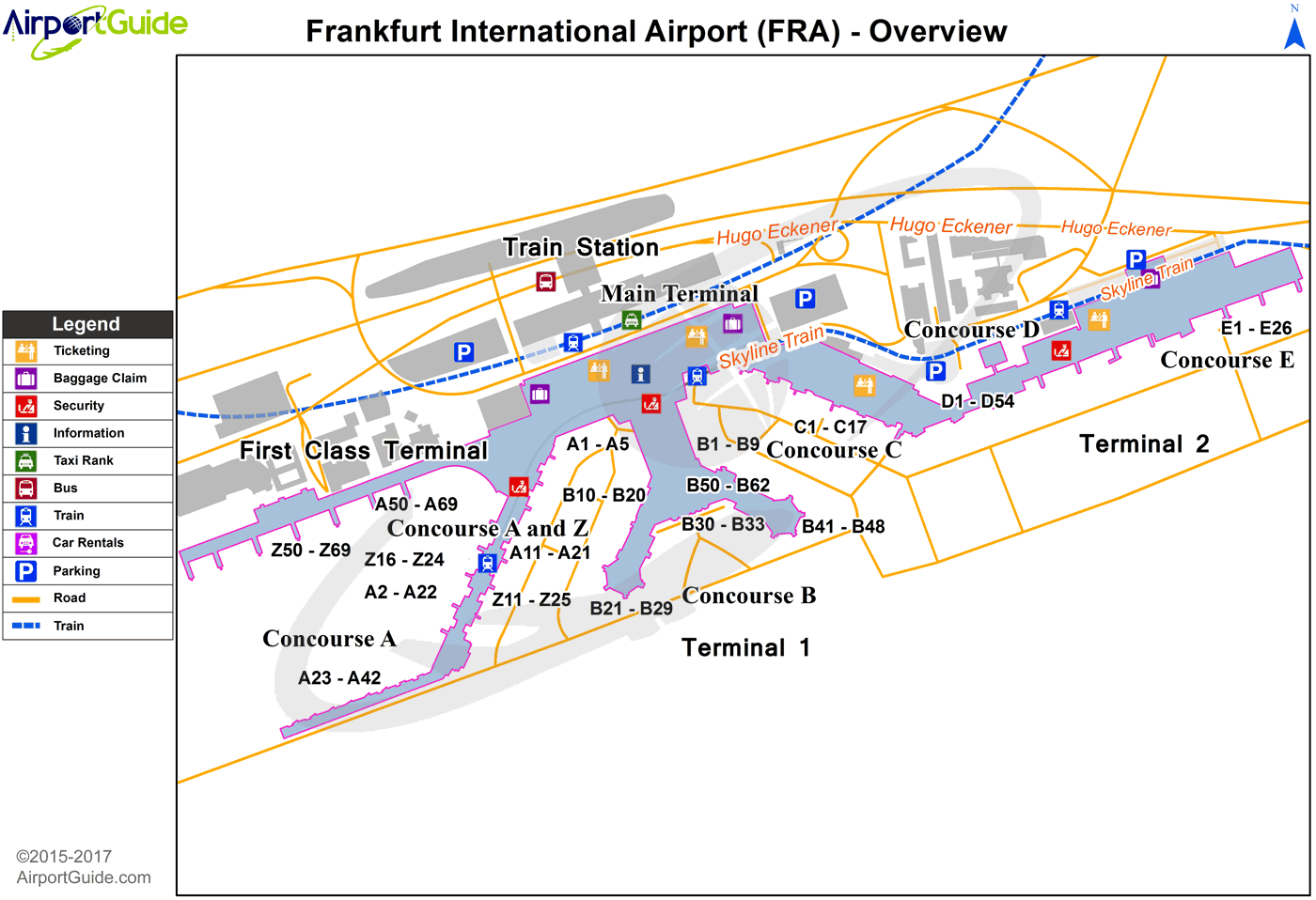
Maps & Diagrams
FRA Sectional
Flight Planning
at skyvector.com
at skyvector.com
