Location
Latitude: |
61-20-10.1800N (61.336161) |
Longitude: |
142-41-09.1900W (-142.685886) |
Elevation: |
1681.0 feet MSL (512 m MSL) |
Magnetic Variation: |
17.1 E (as of April 2024 from WMM2020 model) |
Time Zone: |
UTC -9.0 (Standard Time) UTC -8.0 (Daylight Savings Time) |
From City: |
01 N.M. S of May Creek, Alaska |
Found On: |
Anchorage Chart |
FAA Region: |
AAL |
Contacts
Manager: |
Publicly owned: |
| CHAD HELLER PO BOX 7 GLENALLEN, AK 99588 907-822-3222 |
ALASKA DOT&PF NORTHERN REGION 2301 PEGER ROAD FAIRBANKS, AK 99701 907-451-2200 |
Operations
Airport Status: |
Operational |
Facility Use: |
Public |
Type: |
Airport |
Activation Date: |
07/1950 |
Control tower: |
No |
Attendance (Months/Days/Hours): |
Months/Days/Hours Unattended |
Boundary ARTCC: |
ZAN (Anchorage) |
Responsible ARTCC: |
ZAN (Anchorage) |
Segmented Circle Indicator: |
No |
Traffic Pattern Altitude (MSL): |
2681 feet (817 m) |
NOTAMs Facility: |
ENA |
NOTAM-D Service: |
Yes |
International Airport of Entry: |
No |
Customs Landing Rights: |
No |
Military Landing Rights: |
Yes |
Civil/Military Joint Use: |
No |
Based Aircraft
Annual Operations (as of 12/31/2021)
| Total Operations: | 350 | |
| Air Taxi: | 150 | 42.9% |
| GA Itinerant: | 200 | 57.1% |
Communications
| CTAF: | 122.900 |
Fixed Based Operators (FBOs) & Fuel
(Click on a business for detail)
Please help us keep this information up to date. This is a FREE SERVICE just like everything else on Airport Guide! If you see that a business needs to be added, modified, or deleted please fill out our Update Form.
To add, modify, or delete a business click here.
Please help us keep this information up to date. This is a FREE SERVICE just like everything else on Airport Guide! If you see that a business needs to be added, modified, or deleted please fill out our Update Form.
Area Code: 907 |
| Business Name | Frequency | Phone | Fuel Grade |
|---|
Flight Service Stations
| Primary | Alternate | |
| FSS on Field: | N | |
| FSS Name (ID): | Kenai(ENA) | |
| Frequency: | ||
| Toll Free Phone: | 1-866-864-1737 |
Instrument Procedures / Charts
Terminal Procedures are only available for airports in several countries with more being added all the time. If you are looking for a specific country's charts, please send an email to support(at)airportguide.com stating the country name. This will be used to prioritize the implementation.
Navigation Aids (Navaids) near MYK
| Dist (NM) | ID | Morse Code | Name | Type | Freq | True Hdg | Mag Hdg |
|---|---|---|---|---|---|---|---|
| 75.2 | CYT | _ . _ . _ . _ _ _ | Yakataga | NDB | 209 | 175 | 158 |
| 82.3 | YXQ | _ . _ _ _ . . _ _ _ . _ | Beaver Creek | NDB | 239 | 38 | 21 |
| 92.5 | GKN | _ _ . _ . _ _ . | Gulkana | VOR-DME | 115.60 | 303 | 286 |
| 94.3 | GLA | _ _ . . _ . . . _ | Glennallen | NDB | 248 | 304 | 287 |
| 95.6 | GCR | _ _ . _ . _ . . _ . | Glacier River | NDB | 404 | 239 | 222 |
| 99.1 | ORT | _ _ _ . _ . _ | Northway | VORTAC | 116.30 | 12 | 355 |
| 99.2 | AES | . _ . . . . | Nabesna | NDB | 390 | 12 | 355 |
Nearby Airports with Fuel
| Dist (NM) | Name (Airport IDs) | True Hdg | Mag Hdg | Fuel Grade |
|---|---|---|---|---|
| 99.8 | Northway Airport (ORT PAOR ORT) |
11 | 354 | 100LL, Jet A |
Notices to Airmen (NOTAMS)
Remarks
| A110-1 | ROAD ADJACENT AND ON EAST SIDE OF RY. |
| A110-2 | RY CONDITION NOT MONITORED; RECOMMEND VISUAL INSPECTION PRIOR TO LANDING. |
| A110-3 | GRASS UP TO 1 FT HIGH DURING SUMMER MONTHS. |
| A33-13/31 | SLOPES UP FROM RY 13 END TO RY 31 END. RY 31 THLD ABOUT 100 FT HIGHER. |
| A42-13 | RYS 13 & 31 NSTD MKGS; THLDS MKD WITH CONES & PANELS; PANELS FADED. |
| A52-13 | RY 13/31 77 FT TREES EACH SIDE, FULL LENGTH OF RY CENTERLINE & SAFETY AREA. |
| A55-13 | MOUNTAIN 3 MI FM THLD. |
Runways
Runway Summary
| Runways: | 13/31 |
| Longest Runway: | 13/31 is 2700 ft (823 m) long |
| Runways with an Instrument Approach: |
MYK Airport Runway Details
| Runway 13/31 | 2700 ft x 100 ft (823 m x 30 m) | |
| Surface: | Turf/Gravel - Good condition - No special surface treatment | |
Runway 13 |
Runway 31 |
|
Glide Path Angle: |
0.0 degrees | 0.0 degrees |
Traffic Pattern: |
Left | Left |
Runway Markings Type: |
Nonstandard (other than numbers only) | Nonstandard (other than numbers only) |
Object at End: |
TREES | TREES |
Object Height: |
48 | 70 |
Distance from End: |
0 | 0 |
Object Centerline Offset: |
90 ft. left and right of centerline | 110 ft. left and right of centerline |
Services
Fuel Available: |
100LL, Jet A |
Landing Fees: |
No |
Parking: |
Hangars available |
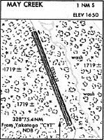
Maps & Diagrams
MYK Sectional
Flight Planning
at skyvector.com
at skyvector.com