Location
Latitude: |
33-25-59.2000N (33.433111) |
Longitude: |
088-50-55.0000W (-88.848611) |
Elevation: |
332.6 feet MSL (101 m MSL) |
Magnetic Variation: |
2.5 W (as of April 2024 from WMM2020 model) |
Time Zone: |
UTC -6.0 (Standard Time) UTC -5.0 (Daylight Savings Time) |
From City: |
03 N.M. SW of Starkville, Mississippi |
Found On: |
Memphis Chart |
FAA Region: |
ASO |
Contacts
Manager: |
Publicly owned: |
| RODNEY LINCOLN PO BOX 1424 STARKVILLE, MS 39760 662-418-5900 |
CITY OF STARKVILLE 101 LAMPKIN ST STARKVILLE, MS 39759 662-323-2525 |
Operations
Airport Status: |
Operational |
Facility Use: |
Public |
Type: |
Airport |
Activation Date: |
04/1940 |
Control tower: |
No |
Attendance (Months/Days/Hours): |
Months/Days/Hours ALL/MON-SAT/0800-1700 |
Boundary ARTCC: |
ZME (Memphis) |
Responsible ARTCC: |
ZME (Memphis) |
Lighting Schedule: |
SEE RMK |
Segmented Circle Indicator: |
Yes |
Traffic Pattern Altitude (MSL): |
1333 feet (406 m) |
NOTAMs Facility: |
GWO |
NOTAM-D Service: |
Yes |
International Airport of Entry: |
No |
Customs Landing Rights: |
No |
Military Landing Rights: |
Yes |
Civil/Military Joint Use: |
No |
Based Aircraft
| Single Engine: | 45 |
| Multi Engine: | 2 |
| Jet Engine: | 3 |
| Gliders: | 7 |
Annual Operations (as of 02/17/2023)
| Total Operations: | 31237 | |
| GA Local: | 20529 | 65.7% |
| GA Itinerant: | 9987 | 32.0% |
| Military Aircraft: | 721 | 2.3% |
Communications
| CTAF: | 122.700 |
| Unicom: | 122.700 |
| Clearance Del.: | 126.25 126.25 126.25 |
| Approach: | COLUMBUS MEMPHIS ARTCC |
| Departure: | COLUMBUS MEMPHIS ARTCC |
| AWOS-3PT: | 118.975 (662-323-4966) |
- APCH/DEP SVC PRVDD BY MEMPHIS ARTCC (COLUMBUS RCAG) ON FREQS 127.1/269.4 WHEN COLUMBUS APCH CTL CLSD.
Fixed Based Operators (FBOs) & Fuel
(Click on a business for detail)
Please help us keep this information up to date. This is a FREE SERVICE just like everything else on Airport Guide! If you see that a business needs to be added, modified, or deleted please fill out our Update Form.
To add, modify, or delete a business click here.
Please help us keep this information up to date. This is a FREE SERVICE just like everything else on Airport Guide! If you see that a business needs to be added, modified, or deleted please fill out our Update Form.
Area Code: 662 |
| Business Name | Frequency | Phone | Fuel Grade |
|---|---|---|---|
| Air Academy International, Inc.
Update FBO info |
Unicom 122.7 | 323-0079 | |
| Starkville Air Services, Inc.
Update FBO info |
Unicom 122.7 | 323-7321 | 100LL, Jet A |
Flight Service Stations
| Primary | Alternate | |
| FSS on Field: | N | |
| FSS Name (ID): | Greenwood(GWO) | |
| Frequency: | ||
| Toll Free Phone: | 1-800-WX-BRIEF |
Instrument Procedures / Charts
FAA Terminal Procedures valid from 0901Z 03/21/24 to 0901Z 04/18/24.
There are various types of charts available for an airport. They are listed in the Page Type column. Here is a legend for those types:
APD - Airport Diagram
DP - Departure Procedure Charts
HOT - Hot Spots
IAP - Instrument Approach Procedure Charts
MIN - Minimums
STAR - Standard Terminal Arrival Charts
| Page Type | Page Name | Volume | Action Since Last Cycle |
|---|---|---|---|
| IAP | LOC/DME RWY 36 | SC-4 | |
| IAP | RNAV (GPS) RWY 18 | SC-4 | |
| IAP | RNAV (GPS) RWY 36 | SC-4 | |
| MIN | ALTERNATE MINIMUMS | SC-4 | |
| MIN | TAKEOFF MINIMUMS | SC-4 |
Terminal Procedures are only available for airports in several countries with more being added all the time. If you are looking for a specific country's charts, please send an email to support(at)airportguide.com stating the country name. This will be used to prioritize the implementation.
Navigation Aids (Navaids) near KSTF
| Dist (NM) | ID | Morse Code | Name | Type | Freq | True Hdg | Mag Hdg |
|---|---|---|---|---|---|---|---|
| 17.1 | IGB | . . _ _ . _ . . . | Bigbee | VORTAC | 116.20 | 79 | 82 |
| 24.0 | CBM | _ . _ . _ . . . _ _ | Caledonia | VORTAC | 115.20 | 58 | 61 |
| 45.0 | TU | _ . . _ | Veron | NDB | 420 | 5 | 8 |
| 47.5 | OTB | _ _ _ _ _ . . . | Tupelo | VOR-DME | 109.80 | 3 | 6 |
| 53.5 | NMM | _ . _ _ _ _ | Meridian | TACAN | 111.90 | 163 | 166 |
| 58.1 | SBQ | . . . _ . . . _ _ . _ | Scobey | NDB | 245 | 298 | 300 |
| 61.3 | TC | _ _ . _ . | Tuske | NDB | 362 | 105 | 108 |
| 62.1 | HAB | . . . . . _ _ . . . | Hamilton | DME | 110.4 | 42 | 45 |
| 62.6 | GW | _ _ . . _ _ | Teock | NDB | 349 | 279 | 281 |
| 63.3 | MEI | _ _ . . . | Meridian | VORTAC | 117.00 | 177 | 179 |
| 66.6 | LDK | . _ . . _ . . _ . _ | Crimson | TACAN | 117.80 | 98 | 101 |
| 66.9 | EWA | . . _ _ . _ | Kewanee | DME | 113.8 | 162 | 165 |
| 69.0 | UV | . . _ . . . _ | Tunng | NDB | 426 | 326 | 328 |
| 71.3 | ME | _ _ . | Savoy | NDB | 356 | 176 | 178 |
| 71.6 | SQS | . . . _ _ . _ . . . | Sidon | VORTAC | 114.70 | 271 | 273 |
| 81.0 | OKW | _ _ _ _ . _ . _ _ | Brookwood | VORTAC | 111.00 | 97 | 100 |
| 86.4 | HLI | . . . . . _ . . . . | Holly Springs | VORTAC | 112.40 | 338 | 340 |
| 86.6 | JAN | . _ _ _ . _ _ . | Jackson | VORTAC | 112.60 | 230 | 232 |
| 87.0 | MHZ | _ _ . . . . _ _ . . | Magnolia | VORTAC | 113.20 | 226 | 228 |
| 88.6 | JA | . _ _ _ . _ | Allen | NDB | 365 | 226 | 228 |
Nearby Airports with Fuel
Notices to Airmen (NOTAMS)
Remarks
| A110-1 | EXPERIMENTAL ACFT ON & INVOF ARPT. |
| A110-2 | FOR CD CTC COLUMBUS APCH AT 662-434-3044. |
| A57-18 | APCH RATIO 49:1 FM DTHR. |
| A70-FUEL-A | FULL SVC AFT HRS - CTC AMGR. FUEL AVBL 24 HRS WITH CREDIT CARD. |
| A75 | PILOTS MUST PRVD TIEDOWN ROPES. |
| A81-APT | 0800-1630; AFT HR ACTVT REIL RWY 36; HIRL RWY 18/36 - CTAF. PAPI RWY 18 & 36 OPR CONSLY. |
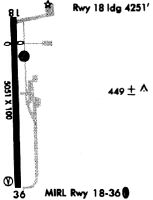
Runways
Runway Summary
| Runways: | 18/36 |
| Longest Runway: | 18/36 is 5550 ft (1692 m) long |
| Runways with an Instrument Approach: | 36 |
KSTF Airport Runway Details
| Runway 18/36 | 5550 ft x 150 ft (1692 m x 46 m) | |
| Runway Length Source: | 3RD PARTY SURVEY as of 06/20/2006 | |
| Surface: | Asphalt/Concrete - Good condition - No special surface treatment | |
| Runway Edge Lights: | High Intensity | |
Runway Weight Bearing Capacity (in thousands of pounds) |
||
| Single Wheel Landing Gear: | 25.0 | |
| Dual Wheel Landing Gear: | 30.0 | |
Runway 18 |
Runway 36 |
|
Elevation: |
332.1 | 320.9 |
Latitude: |
33-26-26.6622N | 33-25-31.7739N |
Longitude: |
088-50-55.7988W | 088-50-54.1464W |
|
Runway True Alignment: |
179 | 359 |
ILS Type: |
LOC/DME | |
Glide Path Angle: |
3.0 degrees | 3.0 degrees |
Traffic Pattern: |
Left | Left |
Runway Markings Type: |
Nonprecision Instrument | Nonprecision Instrument |
Runway Markings Condition: |
Fair | Fair |
Object at End: |
SIGN | |
Object Height: |
32 | |
Distance from End: |
900 | |
Object Centerline Offset: |
150 ft. left of centerline | |
Visual Glide Slope Indicators: |
2-Light PAPI On Left Side Of Runway | 2-Light PAPI On Left Side Of Runway |
REIL: |
Yes | |
Threshold Crossing Height: |
36 | 40 |
Threshold Elevation: |
327.8 | |
Displaced Threshold: |
1379 | |
Threshold Latitude: |
33-26-13.0236N | |
Threshold Longitude: |
088-50-55.3867W |
Services
Airframe Repair: |
None |
Powerplant Repair: |
None |
Bottled Oxygen: |
None |
Bulk Oxygen: |
None |
Fuel Available: |
100LL, Jet A |
Landing Fees: |
No |
Parking: |
Tiedowns available |
Maps & Diagrams
KSTF Sectional
Flight Planning
at skyvector.com
at skyvector.com