Location
Latitude: |
31-22-56.6000N (31.382389) |
Longitude: |
103-30-38.6000W (-103.510722) |
Elevation: |
2613.1 feet MSL (796 m MSL) |
Magnetic Variation: |
6.2 E (as of April 2024 from WMM2020 model) |
Time Zone: |
UTC -6.0 (Standard Time) UTC -5.0 (Daylight Savings Time) |
From City: |
02 N.M. SW of Pecos, Texas |
Found On: |
El Paso Chart |
FAA Region: |
ASW |
Contacts
Manager: |
Publicly owned: |
| COLEY MEANS 3110 MANAHAN STREET PECOS, TX 79772 (512) 422-6396 |
CITY OF PECOS PO BOX 929 PECOS, TX 79772 432-445-2421 |
Operations
Airport Status: |
Operational |
Facility Use: |
Public |
Type: |
Airport |
Activation Date: |
09/1938 |
Control tower: |
No |
Attendance (Months/Days/Hours): |
Months/Days/Hours ALL/ALL/ALL |
Boundary ARTCC: |
ZAB (Albuquerque) |
Responsible ARTCC: |
ZAB (Albuquerque) |
Lighting Schedule: |
SEE RMK |
Segmented Circle Indicator: |
Yes |
Traffic Pattern Altitude (MSL): |
3613 feet (1101 m) |
NOTAMs Facility: |
PEQ |
NOTAM-D Service: |
Yes |
International Airport of Entry: |
No |
Customs Landing Rights: |
No |
Military Landing Rights: |
Yes |
Civil/Military Joint Use: |
No |
Based Aircraft
| Single Engine: | 11 |
| Multi Engine: | 1 |
| Jet Engine: | 1 |
| GA Helicopters: | 1 |
| Gliders: | 1 |
Annual Operations (as of 03/21/2018)
| Total Operations: | 23600 | |
| Air Taxi: | 1800 | 7.6% |
| GA Local: | 8500 | 36.0% |
| GA Itinerant: | 6865 | 29.1% |
| Military Aircraft: | 6435 | 27.3% |
Communications
| CTAF: | 122.800 |
| Unicom: | 122.800 |
| AWOS-3: | 118.175 (432-445-3867) |
- APCH/DEP SVC PRVDD BY ALBUQUERQUE ARTCC (ABQ) ON FREQS 135.875/292.15 (FORT STOCKTON RCAG).
Fixed Based Operators (FBOs) & Fuel
(Click on a business for detail)
Please help us keep this information up to date. This is a FREE SERVICE just like everything else on Airport Guide! If you see that a business needs to be added, modified, or deleted please fill out our Update Form.
To add, modify, or delete a business click here.
Please help us keep this information up to date. This is a FREE SERVICE just like everything else on Airport Guide! If you see that a business needs to be added, modified, or deleted please fill out our Update Form.
Area Code: 915 |
| Business Name | Frequency | Phone | Fuel Grade |
|---|---|---|---|
| Pecos Air Center
Update FBO info |
Unicom 122.8 | 447-2488 | 100LL, Jet A |
Flight Service Stations
| Primary | Alternate | |
| FSS on Field: | N | |
| FSS Name (ID): | San Angelo(SJT) | |
| Frequency: | ||
| Toll Free Phone: | 1-800-WX-BRIEF |
Instrument Procedures / Charts
FAA Terminal Procedures valid from 0901Z 03/21/24 to 0901Z 04/18/24.
There are various types of charts available for an airport. They are listed in the Page Type column. Here is a legend for those types:
APD - Airport Diagram
DP - Departure Procedure Charts
HOT - Hot Spots
IAP - Instrument Approach Procedure Charts
MIN - Minimums
STAR - Standard Terminal Arrival Charts
| Page Type | Page Name | Volume | Action Since Last Cycle |
|---|---|---|---|
| IAP | RNAV (GPS) RWY 14 | SC-3 | |
| IAP | RNAV (GPS) RWY 32 | SC-3 | |
| MIN | ALTERNATE MINIMUMS | SC-3 | |
| MIN | TAKEOFF MINIMUMS | SC-3 |
Terminal Procedures are only available for airports in several countries with more being added all the time. If you are looking for a specific country's charts, please send an email to support(at)airportguide.com stating the country name. This will be used to prioritize the implementation.
Navigation Aids (Navaids) near PEQ
| Dist (NM) | ID | Morse Code | Name | Type | Freq | True Hdg | Mag Hdg |
|---|---|---|---|---|---|---|---|
| 6.2 | PEQ | . _ _ . . _ _ . _ | Pecos | VOR-DME | 116.50 | 327 | 321 |
| 32.5 | INK | . . _ . _ . _ | Wink | VORTAC | 112.10 | 24 | 18 |
| 37.7 | FST | . . _ . . . . _ | Fort Stockton | VORTAC | 116.90 | 133 | 127 |
| 42.0 | XAA | _ . . _ . _ . _ | Kent | NDB | 225 | 238 | 232 |
| 55.9 | BWR | _ . . . . _ _ . _ . | Brewster County | NDB | 412 | 187 | 181 |
| 63.9 | CNM | _ . _ . _ . _ _ | Carlsbad | VORTAC | 116.30 | 325 | 319 |
| 67.8 | CV | _ . _ . . . . _ | Carlz | NDB | 402 | 321 | 315 |
| 68.2 | VHN | . . . _ . . . . _ . | Van Horn | NDB | 233 | 253 | 247 |
| 68.6 | IMP | . . _ _ . _ _ . | Marathon | NDB | 388 | 168 | 162 |
| 68.9 | MRF | _ _ . _ . . . _ . | Marfa | VOR-DME | 115.90 | 199 | 193 |
| 70.6 | MA | _ _ . _ | Farly | NDB | 326 | 58 | 52 |
| 74.8 | MAF | _ _ . _ . . _ . | Midland | VOT | 108.20 | 63 | 57 |
| 76.3 | HOB | . . . . _ _ _ _ . . . | Hobbs | VORTAC | 111.00 | 9 | 3 |
| 77.2 | MAF | _ _ . _ . . _ . | Midland | VORTAC | 114.80 | 60 | 54 |
| 83.5 | SFL | . . . . . _ . . _ . . | Salt Flat | VORTAC | 113.00 | 285 | 278 |
| 89.0 | GNC | _ _ . _ . _ . _ . | Gaines County | NDB | 344 | 29 | 23 |
| 96.1 | HUP | . . . . . . _ . _ _ . | Hudspeth | VORTAC | 115.00 | 277 | 270 |
Nearby Airports with Fuel
Notices to Airmen (NOTAMS)
Remarks
| A110*G | THIS AIRPORT HAS BEEN SURVEYED BY THE NATIONAL GEODETIC SURVEY. |
| A110-1 | FOR CD IF UNA TO CTC ON FSS FREQ, CTC ALBUQUERQUE ARTCC AT 505-856-4561. |
| A43-14 | PAPI OTS |
| A70-FUEL-10 | 0LL FOR FUEL AFTER HOURS CTC UNICOM 122.8 OR CALL 432-447-2488. |
| A81-APT | MIRL RY 14/32 PRESET LOW INTST; TO INCR INTST & ACTVT MIRL RY 09/27 - CTAF. PAPI RYS 14 & 32 OPERATES CONTINUOUSLY. |
Runways
Runway Summary
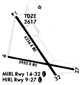
| Runways: | 09/27 14/32 |
| Longest Runway: | 14/32 is 6236 ft (1901 m) long |
| Runways with an Instrument Approach: |
PEQ Airport Runway Details
| Runway 09/27 | 5953 ft x 80 ft (1814 m x 24 m) | |
| Runway Length Source: | NGS as of 02/08/2008 | |
| Surface: | Asphalt - Good condition - No special surface treatment | |
| Runway Edge Lights: | Medium Intensity | |
Runway Weight Bearing Capacity (in thousands of pounds) |
||
| Single Wheel Landing Gear: | 25.0 | |
| Dual Wheel Landing Gear: | 37.0 | |
Runway 09 |
Runway 27 |
|
Elevation: |
2613.0 | 2597.9 |
Latitude: |
31-22-54.5924N | 31-22-43.1481N |
Longitude: |
103-31-09.3056W | 103-30-01.9500W |
|
Runway True Alignment: |
101 | 281 |
Glide Path Angle: |
0.0 degrees | 0.0 degrees |
Traffic Pattern: |
Left | Left |
Runway Markings Type: |
Nonprecision Instrument | Nonprecision Instrument |
Runway Markings Condition: |
Good | Good |
Object at End: |
PLINE | |
Object Height: |
45 | |
Object Marked/Lighted?: |
Marked | |
Distance from End: |
2020 | |
Object Centerline Offset: |
0 ft. left and right of centerline |
| Runway 14/32 | 6236 ft x 80 ft (1901 m x 24 m) | |
| Runway Length Source: | NGS as of 02/08/2008 | |
| Surface: | Asphalt - Good condition - No special surface treatment | |
| Runway Edge Lights: | Medium Intensity | |
Runway Weight Bearing Capacity (in thousands of pounds) |
||
| Single Wheel Landing Gear: | 25.0 | |
| Dual Wheel Landing Gear: | 37.0 | |
Runway 14 |
Runway 32 |
|
Elevation: |
2608.1 | 2600.9 |
Latitude: |
31-23-29.5284N | 31-22-38.2477N |
Longitude: |
103-31-01.3649W | 103-30-21.3643W |
|
Runway True Alignment: |
146 | 326 |
Glide Path Angle: |
3.0 degrees | 3.0 degrees |
Traffic Pattern: |
Left | Left |
Runway Markings Type: |
Nonprecision Instrument | Nonprecision Instrument |
Runway Markings Condition: |
Good | Good |
Object at End: |
BRUSH | |
Object Height: |
10 | |
Distance from End: |
200 | |
Object Centerline Offset: |
0 ft. left and right of centerline | |
Visual Glide Slope Indicators: |
2-Light PAPI On Left Side Of Runway | 2-Light PAPI On Left Side Of Runway |
Threshold Crossing Height: |
40 | 40 |
Services
Airframe Repair: |
Major |
Powerplant Repair: |
Major |
Bottled Oxygen: |
High Pressure |
Bulk Oxygen: |
High Pressure |
Fuel Available: |
100LL, Jet A |
Landing Fees: |
No |
Parking: |
Hangars and tiedowns available |
Maps & Diagrams
PEQ Sectional
Flight Planning
at skyvector.com
at skyvector.com