Location
Latitude: |
32-28-02.5000N (32.467361) |
Longitude: |
100-27-59.6000W (-100.466556) |
Elevation: |
2379.7 feet MSL (725 m MSL) |
Magnetic Variation: |
4.8 E (as of May 2024 from WMM2020 model) |
Time Zone: |
UTC -6.0 (Standard Time) UTC -5.0 (Daylight Savings Time) |
From City: |
03 N.M. W of Sweetwater, Texas |
Found On: |
Dallas-Ft Worth Chart |
FAA Region: |
ASW |
Contacts
Manager: |
Publicly owned: |
| LYNN BARRETT P.O. BOX 450 SWEETWATER, TX 79556 325-235-8478 |
CITY OF SWEETWATER PO BOX 450 SWEETWATER, TX 79556 325-236-6313 |
Operations
Airport Status: |
Operational |
Facility Use: |
Public |
Type: |
Airport |
Activation Date: |
12/1946 |
Control tower: |
No |
Attendance (Months/Days/Hours): |
Months/Days/Hours ALL/ALL/0800-1800 |
Boundary ARTCC: |
ZFW (Fort Worth) |
Responsible ARTCC: |
ZFW (Fort Worth) |
Lighting Schedule: |
SS-SR |
Segmented Circle Indicator: |
Yes |
Traffic Pattern Altitude (MSL): |
3380 feet (1030 m) |
NOTAMs Facility: |
SWW |
NOTAM-D Service: |
Yes |
International Airport of Entry: |
No |
Customs Landing Rights: |
No |
Military Landing Rights: |
Yes |
Civil/Military Joint Use: |
No |
Based Aircraft
| Single Engine: | 14 |
| Multi Engine: | 1 |
| GA Helicopters: | 1 |
Annual Operations (as of 05/23/2021)
| Total Operations: | 3900 | |
| GA Local: | 2600 | 66.7% |
| GA Itinerant: | 1300 | 33.3% |
Communications
| CTAF: | 122.800 |
| Unicom: | 122.800 |
| Approach: | ABILENE 127.2 127.2 |
| Departure: | ABILENE 127.2 127.2 |
| AWOS-3: | 119.025 (325-236-9652) |
Fixed Based Operators (FBOs) & Fuel
(Click on a business for detail)
Please help us keep this information up to date. This is a FREE SERVICE just like everything else on Airport Guide! If you see that a business needs to be added, modified, or deleted please fill out our Update Form.
To add, modify, or delete a business click here.
Please help us keep this information up to date. This is a FREE SERVICE just like everything else on Airport Guide! If you see that a business needs to be added, modified, or deleted please fill out our Update Form.
Area Code: 915 |
| Business Name | Frequency | Phone | Fuel Grade |
|---|---|---|---|
| Avenger Air
Update FBO info |
Unicom 122.8 | 235-8478 | 100LL, Jet A |
Flight Service Stations
| Primary | Alternate | |
| FSS on Field: | N | |
| FSS Name (ID): | Fort Worth(FTW) | |
| Frequency: | ||
| Toll Free Phone: | 1-800-WX-BRIEF |
Instrument Procedures / Charts
FAA Terminal Procedures valid from 0901Z 03/21/24 to 0901Z 04/18/24.
There are various types of charts available for an airport. They are listed in the Page Type column. Here is a legend for those types:
APD - Airport Diagram
DP - Departure Procedure Charts
HOT - Hot Spots
IAP - Instrument Approach Procedure Charts
MIN - Minimums
STAR - Standard Terminal Arrival Charts
| Page Type | Page Name | Volume | Action Since Last Cycle |
|---|---|---|---|
| IAP | RNAV (GPS) RWY 04 | SC-2 | |
| IAP | RNAV (GPS) RWY 17 | SC-2 | |
| IAP | RNAV (GPS) RWY 22 | SC-2 | |
| IAP | RNAV (GPS) RWY 35 | SC-2 | |
| MIN | ALTERNATE MINIMUMS | SC-2 | |
| MIN | TAKEOFF MINIMUMS | SC-2 |
Terminal Procedures are only available for airports in several countries with more being added all the time. If you are looking for a specific country's charts, please send an email to support(at)airportguide.com stating the country name. This will be used to prioritize the implementation.
Navigation Aids (Navaids) near SWW
| Dist (NM) | ID | Morse Code | Name | Type | Freq | True Hdg | Mag Hdg |
|---|---|---|---|---|---|---|---|
| 0.3 | SWW | . . . . _ _ . _ _ | Sweetwater | NDB | 275 | 172 | 167 |
| 28.0 | SDR | . . . _ . . . _ . | Snyder | NDB | 359 | 300 | 295 |
| 30.5 | ABI | . _ _ . . . . . | Abilene | VORTAC | 113.70 | 88 | 83 |
| 31.0 | DYS | _ . . _ . _ _ . . . | Dyess | TACAN | 133.60 | 95 | 90 |
| 35.7 | TQA | _ _ _ . _ . _ | Tuscola | VOR-DME | 111.60 | 112 | 107 |
| 41.4 | AB | . _ _ . . . | Tomhi | NDB | 353 | 103 | 98 |
| 51.7 | BGS | _ . . . _ _ . . . . | Big Spring | VORTAC | 117.20 | 264 | 259 |
| 53.4 | UBC | . . _ _ . . . _ . _ . | Ballinger | NDB | 239 | 151 | 146 |
| 57.5 | AKL | . _ _ . _ . _ . . | Haskell | NDB | 407 | 40 | 35 |
| 65.5 | SJT | . . . . _ _ _ _ | San Angelo | VORTAC | 115.10 | 179 | 174 |
| 71.5 | SJ | . . . . _ _ _ | Woole | NDB | 356 | 184 | 179 |
| 75.3 | LSA | . _ . . . . . . _ | Lamesa | NDB | 338 | 283 | 278 |
| 78.9 | GTH | _ _ . _ . . . . | Guthrie | DME | 114.5 | 4 | 359 |
| 79.5 | CZX | _ . _ . _ _ . . _ . . _ | Crosbyton | NDB | 332 | 330 | 325 |
| 84.0 | OIP | _ _ _ . . . _ _ . | Old Rip | NDB | 410 | 92 | 88 |
| 84.0 | BWD | _ . . . . _ _ _ . . | Brownwood | VOR-DME | 113.55 | 113 | 109 |
| 91.7 | MAF | _ _ . _ . . _ . | Midland | VORTAC | 114.80 | 253 | 248 |
| 93.6 | MAF | _ _ . _ . . _ . | Midland | VOT | 108.20 | 250 | 245 |
| 95.6 | LD | . _ . . _ . . | Lubbi | NDB | 272 | 318 | 313 |
| 96.9 | BBD | _ . . . _ . . . _ . . | Brady | NDB | 380 | 142 | 138 |
Nearby Airports with Fuel
Notices to Airmen (NOTAMS)
Remarks
| A110-1 | FOR CD CTC FORT WORTH ARTCC AT 817-858-7584. |
| A110-2 | (CONTACT PHONE NR) LENHOBBS122@GMAIL.COM |
| A17 | HOLIDAYS INTMT |
| A58-22 | +15 FT GRVL ROAD 199 FT FM THR, 236 FT L OF CNTRLN. |
| A70-FUEL-10 | 0LL FOR FUEL AFT HRS CALL 325-235-8478. |
Runways
Runway Summary
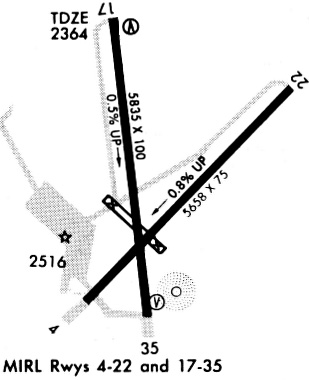
| Runways: | 04/22 17/35 |
| Longest Runway: | 17/35 is 5840 ft (1780 m) long |
| Runways with an Instrument Approach: |
SWW Airport Runway Details
| Runway 04/22 | 5658 ft x 75 ft (1725 m x 23 m) | |
| Runway Length Source: | 3RD PARTY SURVEY as of 11/11/2009 | |
| Surface: | Asphalt - Good condition - No special surface treatment | |
| Runway Edge Lights: | Medium Intensity | |
Runway Weight Bearing Capacity (in thousands of pounds) |
||
| Single Wheel Landing Gear: | 30.0 | |
Runway 04 |
Runway 22 |
|
Elevation: |
2379.5 | 2336.9 |
Latitude: |
32-27-39.5427N | 32-28-20.1965N |
Longitude: |
100-28-15.4459W | 100-27-30.0623W |
|
Runway True Alignment: |
043 | 223 |
Glide Path Angle: |
3.0 degrees | 3.0 degrees |
Traffic Pattern: |
Left | Left |
Runway Markings Type: |
Nonprecision Instrument | Nonprecision Instrument |
Runway Markings Condition: |
Good | Good |
Object at End: |
TREES | POLE |
Object Height: |
37 | 35 |
Distance from End: |
1060 | 555 |
Object Centerline Offset: |
300 ft. right of centerline | 245 ft. right of centerline |
Visual Glide Slope Indicators: |
2-Light PAPI On Left Side Of Runway | 2-Light PAPI On Left Side Of Runway |
Threshold Crossing Height: |
40 | 40 |
| Runway 17/35 | 5840 ft x 100 ft (1780 m x 30 m) | |
| Runway Length Source: | 3RD PARTY SURVEY as of 11/11/2009 | |
| Surface: | Asphalt - Good condition - No special surface treatment | |
| Runway Edge Lights: | Medium Intensity | |
Runway Weight Bearing Capacity (in thousands of pounds) |
||
| Single Wheel Landing Gear: | 30.0 | |
Runway 17 |
Runway 35 |
|
Elevation: |
2340.7 | 2369.0 |
Latitude: |
32-28-33.7657N | 32-27-36.3467N |
Longitude: |
100-28-10.0695W | 100-28-02.5314W |
|
Runway True Alignment: |
174 | 354 |
Glide Path Angle: |
3.0 degrees | 3.0 degrees |
Traffic Pattern: |
Left | Left |
Runway Markings Type: |
Nonprecision Instrument | Nonprecision Instrument |
Runway Markings Condition: |
Good | Good |
Object at End: |
TREES | POLE |
Object Height: |
12 | 37 |
Distance from End: |
388 | 820 |
Object Centerline Offset: |
300 ft. right of centerline | 245 ft. right of centerline |
Visual Glide Slope Indicators: |
4-Light PAPI On Left Side Of Runway | 4-Light PAPI On Left Side Of Runway |
REIL: |
Yes | Yes |
Threshold Crossing Height: |
40 | 40 |
Services
Airframe Repair: |
Major |
Powerplant Repair: |
Major |
Bottled Oxygen: |
None |
Bulk Oxygen: |
None |
Fuel Available: |
100LL, Jet A |
Landing Fees: |
No |
Parking: |
Hangars and tiedowns available |
Maps & Diagrams
SWW Sectional
Flight Planning
at skyvector.com
at skyvector.com