Location
Latitude: |
48-05-40.2000N (48.0945) |
Longitude: |
105-34-30.2000W (-105.575056) |
Elevation: |
1988.5 feet MSL (606 m MSL) |
Magnetic Variation: |
8.8 E (as of May 2024 from WMM2020 model) |
Time Zone: |
UTC -7.0 (Standard Time) UTC -6.0 (Daylight Savings Time) |
From City: |
03 N.M. NE of Wolf Point, Montana |
Found On: |
Billings Chart |
FAA Region: |
ANM |
Contacts
Manager: |
Publicly owned: |
| ED BACH WOLF POINT AIRPORT, 201 4TH AVE SOUTH WOLF POINT, MT 59201 (406) 650-8305 |
CITY OF WOLF POINT-ROOSEVELT COUNTY 201 4TH AVE SOUTH WOLF POINT, MT 59201 406-653-1852 |
Operations
Airport Status: |
Operational |
Facility Use: |
Public |
Type: |
Airport |
Activation Date: |
04/1940 |
Control tower: |
No |
Attendance (Months/Days/Hours): |
Months/Days/Hours ALL/MON-FRI/0600-1930 |
Boundary ARTCC: |
ZLC (Salt Lake City) |
Responsible ARTCC: |
ZLC (Salt Lake City) |
Lighting Schedule: |
SEE RMK |
Segmented Circle Indicator: |
Yes |
Traffic Pattern Altitude (MSL): |
2988 feet (911 m) |
NOTAMs Facility: |
OLF |
NOTAM-D Service: |
Yes |
International Airport of Entry: |
No |
Customs Landing Rights: |
No |
Military Landing Rights: |
Yes |
Civil/Military Joint Use: |
No |
Based Aircraft
| Single Engine: | 3 |
Annual Operations (as of 06/04/2019)
| Total Operations: | 4602 | |
| Air Taxi: | 1568 | 34.1% |
| GA Local: | 2100 | 45.6% |
| GA Itinerant: | 930 | 20.2% |
| Military Aircraft: | 4 | 0.1% |
Communications
| CTAF: | 122.800 |
| Unicom: | 122.800 |
| ASOS: | 118.325 (406-653-3865) |
- APCH/DEP CTL SVC PRVDD BY SALT LAKE ARTCC (ZLC) ON FREQS 126.85/305.2 (GLASGOW RCAG).
Fixed Based Operators (FBOs) & Fuel
(Click on a business for detail)
Please help us keep this information up to date. This is a FREE SERVICE just like everything else on Airport Guide! If you see that a business needs to be added, modified, or deleted please fill out our Update Form.
To add, modify, or delete a business click here.
Please help us keep this information up to date. This is a FREE SERVICE just like everything else on Airport Guide! If you see that a business needs to be added, modified, or deleted please fill out our Update Form.
Area Code: 406 |
| Business Name | Frequency | Phone | Fuel Grade |
|---|---|---|---|
| French Aviation
Update FBO info |
Unicom 122.8 | 653-1740 | 100LL, Jet A |
Flight Service Stations
| Primary | Alternate | |
| FSS on Field: | N | |
| FSS Name (ID): | Great Falls(GTF) | |
| Frequency: | ||
| Toll Free Phone: | 1-800-WX-BRIEF |
Instrument Procedures / Charts
FAA Terminal Procedures valid from 0901Z 03/21/24 to 0901Z 04/18/24.
There are various types of charts available for an airport. They are listed in the Page Type column. Here is a legend for those types:
APD - Airport Diagram
DP - Departure Procedure Charts
HOT - Hot Spots
IAP - Instrument Approach Procedure Charts
MIN - Minimums
STAR - Standard Terminal Arrival Charts
| Page Type | Page Name | Volume | Action Since Last Cycle |
|---|---|---|---|
| APD | AIRPORT DIAGRAM | NW-1 | |
| IAP | RNAV (GPS) RWY 11 | NW-1 | |
| IAP | RNAV (GPS) RWY 29 | NW-1 | |
| MIN | ALTERNATE MINIMUMS | NW-1 |
Terminal Procedures are only available for airports in several countries with more being added all the time. If you are looking for a specific country's charts, please send an email to support(at)airportguide.com stating the country name. This will be used to prioritize the implementation.
Navigation Aids (Navaids) near OLF
| Dist (NM) | ID | Morse Code | Name | Type | Freq | True Hdg | Mag Hdg |
|---|---|---|---|---|---|---|---|
| 1.2 | OLF | _ _ _ . _ . . . . _ . | Wolf Point | NDB | 404 | 298 | 289 |
| 40.5 | CRR | _ . _ . . _ . . _ . | Circle | NDB | 245 | 179 | 170 |
| 42.6 | MKR | _ _ _ . _ . _ . | Milk River | NDB | 339 | 279 | 270 |
| 42.7 | GGW | _ _ . _ _ . . _ _ | Glasgow | VOR-DME | 113.90 | 280 | 271 |
| 43.1 | SCO | . . . _ . _ . _ _ _ | Scobey | NDB | 283 | 7 | 358 |
| 58.8 | PWD | . _ _ . . _ _ _ . . | Plentywood | NDB | 251 | 44 | 35 |
| 60.6 | SDY | . . . _ . . _ . _ _ | Sidney | NDB | 359 | 111 | 103 |
| 65.5 | GDV | _ _ . _ . . . . . _ | Glendive | NDB | 410 | 151 | 142 |
| 65.5 | GDV | _ _ . _ . . . . . _ | Glendive | DME | 114.35 | 151 | 142 |
| 71.5 | JDN | . _ _ _ _ . . _ . | Jordan | NDB | 263 | 230 | 221 |
| 73.6 | ISN | . . . . . _ . | Williston | VOR-DME | 116.30 | 81 | 73 |
| 79.8 | ISN | . . . . . _ . | Williston | NDB | 275 | 87 | 79 |
| 82.7 | SF | . . . . . _ . | Yuson | NDB | 275 | 88 | 80 |
| 95.0 | MLK | _ _ . _ . . _ . _ | Malta | NDB | 272 | 280 | 271 |
| 99.1 | NI | Assiniboia | NDB | 278 | 351 | 342 |
Nearby Airports with Fuel
| Dist (NM) | Name (Airport IDs) | True Hdg | Mag Hdg | Fuel Grade |
|---|---|---|---|---|
| 34.4 | Richey Airport (7U8) |
144 | 136 | 80, 100LL |
| 40.6 | Circle Town County Airport (4U6) |
179 | 170 | 100LL |
| 42.2 | Wokal Field/Glasgow-Valley County Airport (GGW KGGW GGW) |
280 | 271 | 100LL, Jet A-1+ |
| 43.0 | Big Sky Field Airport (S85) |
84 | 76 | 100LL |
| 43.1 | Scobey Airport (9S2) |
7 | 358 | 100LL, Jet A |
| 59.1 | Sher-Wood Airport (PWD KPWD PWD) |
44 | 36 | 100LL |
| 60.3 | Sidney-Richland Regional Airport (SDY KSDY SDY) |
112 | 104 | 100LL, Jet A |
| 65.2 | Dawson Community Airport (GDV KGDV GDV) |
151 | 143 | 100LL, Jet A+ |
| 95.1 | Malta Airport (MLK M75) |
280 | 270 | 100LL, Jet A+ |
Notices to Airmen (NOTAMS)
Remarks
| A110-1 | WILDLIFE HAZ; WATERFOWL IN VCNTY. |
| A110-2 | FOR CD IF UNA TO CTC ON FSS FREQ, CTC SALT LAKE ARTCC AT 801-320-2568. |
| A14 | ALTN MGR TOM ROMO WITH SAME CTC INFO AS ED BACH. |
| A17 | AIRFIELD SFC CONDS NOT MONTRD 2200-0500. |
| A17 1 | FOR SVC AFT NML BUS HRS CALL AMGR 406-688-8308 OR 406-650-8305. |
| A70-FUEL-10 | 0LL 24 HR SELF SVC CREDIT CARD FUEL FAC. JET A FUEL NOT AVBL. |
| A81-APT | ACTVT REIL RWY 11 & 29; PAPI RWY 11 & 29; MIRL RWY 11/29 - CTAF. |
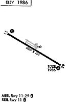
Runways
Runway Summary
| Runways: | 11/29 |
| Longest Runway: | 11/29 is 5091 ft (1552 m) long |
| Runways with an Instrument Approach: |
OLF Airport Runway Details
| Runway 11/29 | 5091 ft x 100 ft (1552 m x 30 m) | |
| Runway Length Source: | 3RD PARTY SURVEY as of 07/21/2011 | |
| Surface: | Asphalt - Good condition - Saw-cut or plastic grooved | |
| Runway Pavement Class: | 14 /F/D/X/U | |
| Runway Edge Lights: | Medium Intensity | |
Runway Weight Bearing Capacity (in thousands of pounds) |
||
| Single Wheel Landing Gear: | 38.0 | |
| Dual Wheel Landing Gear: | 50.0 | |
Runway 11 |
Runway 29 |
|
Elevation: |
1986.8 | 1985.3 |
Latitude: |
48-05-52.7781N | 48-05-27.6729N |
Longitude: |
105-35-02.6702W | 105-33-57.7204W |
|
Runway True Alignment: |
120 | 300 |
Glide Path Angle: |
3.0 degrees | 3.0 degrees |
Traffic Pattern: |
Left | Left |
Runway Markings Type: |
Nonprecision Instrument | Nonprecision Instrument |
Runway Markings Condition: |
Good | Good |
Visual Glide Slope Indicators: |
2-Light PAPI On Left Side Of Runway | 2-Light PAPI On Left Side Of Runway |
REIL: |
Yes | Yes |
Threshold Crossing Height: |
28 | 29 |
Services
Airframe Repair: |
None |
Powerplant Repair: |
None |
Bottled Oxygen: |
None |
Bulk Oxygen: |
None |
Fuel Available: |
100LL, Jet A+ |
Landing Fees: |
No |
Parking: |
Hangars and tiedowns available |
Maps & Diagrams
OLF Sectional
Flight Planning
at skyvector.com
at skyvector.com