Location
Latitude: |
33-29-51.6439N (33.497679) |
Longitude: |
088-40-53.1189W (-88.681422) |
Elevation: |
250.0 feet MSL (76 m MSL) |
Magnetic Variation: |
2.6 W (as of April 2024 from WMM2020 model) |
Time Zone: |
UTC -6.0 (Standard Time) UTC -5.0 (Daylight Savings Time) |
From City: |
07 N.M. NE of Starkville, Mississippi |
Found On: |
Memphis Chart |
FAA Region: |
ASO |
Contacts
Manager: |
Privately owned: |
| DOUG CAMP 1606 CAMP AIRPORT RD STARKVILLE, MS 39759 662-341-2345 |
DOUG CAMP 1606 CAMP AIRPORT RD STARKVILLE, MS 39759 662-431-2345 |
Operations
Airport Status: |
Operational |
Facility Use: |
Public |
Type: |
Airport |
Activation Date: |
01/1943 |
Control tower: |
No |
Attendance (Months/Days/Hours): |
Months/Days/Hours ALL/SAT-SUN/ALL |
Boundary ARTCC: |
ZME (Memphis) |
Responsible ARTCC: |
ZME (Memphis) |
Segmented Circle Indicator: |
No |
Traffic Pattern Altitude (MSL): |
1250 feet (381 m) |
NOTAMs Facility: |
GWO |
NOTAM-D Service: |
Yes |
International Airport of Entry: |
No |
Customs Landing Rights: |
No |
Military Landing Rights: |
Yes |
Civil/Military Joint Use: |
No |
Based Aircraft
| Single Engine: | 10 |
Annual Operations (as of 06/02/2023)
| Total Operations: | 2900 | |
| GA Local: | 2200 | 75.9% |
| GA Itinerant: | 500 | 17.2% |
| Military Aircraft: | 200 | 6.9% |
Communications
| CTAF: | 122.800 |
| Unicom: | 122.800 |
| Approach: | COLUMBUS 135.6 135.6 MEMPHIS ARTCC |
| Departure: | COLUMBUS 135.6 135.6 MEMPHIS ARTCC |
- APCH/DEP SVC PRVDD BY MEMPHIS ARTCC (COLUMBUS RCAG) ON FREQS 127.1/269.4 WHEN COLUMBUS APCH CTL CLSD.
Fixed Based Operators (FBOs) & Fuel
(Click on a business for detail)
Please help us keep this information up to date. This is a FREE SERVICE just like everything else on Airport Guide! If you see that a business needs to be added, modified, or deleted please fill out our Update Form.
To add, modify, or delete a business click here.
Please help us keep this information up to date. This is a FREE SERVICE just like everything else on Airport Guide! If you see that a business needs to be added, modified, or deleted please fill out our Update Form.
Area Code: 662 |
| Business Name | Frequency | Phone | Fuel Grade |
|---|
Flight Service Stations
| Primary | Alternate | |
| FSS on Field: | N | |
| FSS Name (ID): | Greenwood(GWO) | |
| Frequency: | ||
| Toll Free Phone: | 1-800-WX-BRIEF |
Instrument Procedures / Charts
FAA Terminal Procedures valid from 0901Z 03/21/24 to 0901Z 04/18/24.
There are various types of charts available for an airport. They are listed in the Page Type column. Here is a legend for those types:
APD - Airport Diagram
DP - Departure Procedure Charts
HOT - Hot Spots
IAP - Instrument Approach Procedure Charts
MIN - Minimums
STAR - Standard Terminal Arrival Charts
| Page Type | Page Name | Volume | Action Since Last Cycle |
|---|---|---|---|
| IAP | RNAV (GPS)-A | SC-4 | |
| MIN | TAKEOFF MINIMUMS | SC-4 |
Terminal Procedures are only available for airports in several countries with more being added all the time. If you are looking for a specific country's charts, please send an email to support(at)airportguide.com stating the country name. This will be used to prioritize the implementation.
Navigation Aids (Navaids) near M51
| Dist (NM) | ID | Morse Code | Name | Type | Freq | True Hdg | Mag Hdg |
|---|---|---|---|---|---|---|---|
| 8.4 | IGB | . . _ _ . _ . . . | Bigbee | VORTAC | 116.20 | 94 | 97 |
| 14.9 | CBM | _ . _ . _ . . . _ _ | Caledonia | VORTAC | 115.20 | 54 | 57 |
| 41.2 | TU | _ . . _ | Veron | NDB | 420 | 353 | 356 |
| 43.9 | OTB | _ _ _ _ _ . . . | Tupelo | VOR-DME | 109.80 | 352 | 355 |
| 53.7 | HAB | . . . . . _ _ . . . | Hamilton | DME | 110.4 | 38 | 41 |
| 54.6 | TC | _ _ . _ . | Tuske | NDB | 362 | 111 | 114 |
| 55.6 | NMM | _ . _ _ _ _ | Meridian | TACAN | 111.90 | 172 | 175 |
| 59.1 | LDK | . _ . . _ . . _ . _ | Crimson | TACAN | 117.80 | 103 | 106 |
| 64.1 | SBQ | . . . _ . . . _ _ . _ | Scobey | NDB | 245 | 291 | 293 |
| 67.4 | MEI | _ _ . . . | Meridian | VORTAC | 117.00 | 185 | 188 |
| 68.7 | EWA | . . _ _ . _ | Kewanee | DME | 113.8 | 170 | 173 |
| 70.4 | GW | _ _ . . _ _ | Teock | NDB | 349 | 275 | 277 |
| 71.0 | UV | . . _ . . . _ | Tunng | NDB | 426 | 318 | 320 |
| 73.4 | OKW | _ _ _ _ . _ . _ _ | Brookwood | VORTAC | 111.00 | 101 | 104 |
| 75.2 | ME | _ _ . | Savoy | NDB | 356 | 183 | 186 |
| 79.9 | SQS | . . . _ _ . _ . . . | Sidon | VORTAC | 114.70 | 268 | 270 |
| 86.4 | HLI | . . . . . _ . . . . | Holly Springs | VORTAC | 112.40 | 332 | 334 |
| 89.7 | VUZ | . . . _ . . _ _ _ . . | Vulcan | VORTAC | 114.40 | 82 | 85 |
| 91.1 | UU | . . _ . . _ | Seyer | NDB | 334 | 2 | 5 |
| 91.8 | BH | _ . . . . . . . | Mcden | NDB | 224 | 88 | 91 |
Nearby Airports with Fuel
Notices to Airmen (NOTAMS)
Remarks
| A110-1 | FOR CD CTC MEMPHIS ARTCC AT 901-368-8453/8449. |
| A30-01/19 | MKD BY MOWING & WHITE JUGS 75 FT APART. |
| A30-14/32 | MKD BY MOWING & WHITE JUGS 75 FT APART. |
| A82 | UNICOM OTS INDEFLY. |
| E111 | PRIOR TO FAA ACT. |
Runways
Runway Summary
| Runways: | 01/19 14/32 |
| Longest Runway: | 14/32 is 2600 ft (792 m) long |
| Runways with an Instrument Approach: |
M51 Airport Runway Details
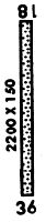
| Runway 01/19 | 2237 ft x 150 ft (682 m x 46 m) | |
| Runway Length Source: | FAA as of 04/12/2013 | |
| Surface: | Turf - Fair condition - No special surface treatment | |
Runway 01 |
Runway 19 |
|
Elevation: |
248.5 | 250.0 |
Latitude: |
33-29-40.5000N | 33-30-02.3900N |
Longitude: |
088-40-53.5800W | 088-40-49.6800W |
|
Runway True Alignment: |
008 | 188 |
Glide Path Angle: |
0.0 degrees | 0.0 degrees |
Traffic Pattern: |
Left | Left |
Runway Markings Type: |
Nonstandard (other than numbers only) | Nonstandard (other than numbers only) |
Runway Markings Condition: |
Fair | Fair |
Object at End: |
TREES | TREES |
Object Height: |
17 | 59 |
Distance from End: |
400 | 1350 |
Object Centerline Offset: |
130 ft. left of centerline | 0 ft. left and right of centerline |
| Runway 14/32 | 2600 ft x 150 ft (792 m x 46 m) | |
| Runway Length Source: | FAA as of 04/12/2013 | |
| Surface: | Turf - Fair condition - No special surface treatment | |
Runway 14 |
Runway 32 |
|
Elevation: |
245.8 | 247.0 |
Latitude: |
33-30-01.9200N | 33-29-41.7100N |
Longitude: |
088-41-03.9000W | 088-40-44.9000W |
|
Runway True Alignment: |
142 | 322 |
Glide Path Angle: |
0.0 degrees | 0.0 degrees |
Runway Markings Type: |
Nonstandard (other than numbers only) | Nonstandard (other than numbers only) |
Runway Markings Condition: |
Fair | Fair |
Object at End: |
TREES | TREES |
Object Height: |
77 | 56 |
Distance from End: |
1800 | 1700 |
Object Centerline Offset: |
130 ft. left of centerline | 0 ft. left and right of centerline |
Services
Airframe Repair: |
None |
Powerplant Repair: |
None |
Bottled Oxygen: |
None |
Bulk Oxygen: |
None |
Fuel Available: |
100LL, Jet A |
Landing Fees: |
No |
Maps & Diagrams
M51 Sectional
Flight Planning
at skyvector.com
at skyvector.com