Location
Latitude: |
63-59-42.5857N (63.995163) |
Longitude: |
145-43-12.1993W (-145.720055) |
Elevation: |
1285.2 feet MSL (392 m MSL) |
Magnetic Variation: |
16.4 E (as of May 2024 from WMM2020 model) |
Time Zone: |
UTC -9.0 (Standard Time) UTC -8.0 (Daylight Savings Time) |
From City: |
03 N.M. S of Delta Junction Ft Greely, Alaska |
Found On: |
Anchorage Chart |
FAA Region: |
AAL |
Contacts
Manager: |
Army owned: |
| HQ 172 INFANTRY BRIGADE FT RICHARDSON ALASKA 99505 907-873-7400 |
U.S. ARMY U.S. ARMY FORCES COMMAND ATLANTA, GA |
Operations
Airport Status: |
Operational |
Facility Use: |
Private |
Type: |
Airport |
Control tower: |
Yes |
Attendance (Months/Days/Hours): |
Months/Days/Hours ALL/MON-FRI/1715-0100Z++ |
Boundary ARTCC: |
ZAN (Anchorage) |
Responsible ARTCC: |
ZAN (Anchorage) |
Lighting Schedule: |
SEE RMK |
Segmented Circle Indicator: |
Yes |
Traffic Pattern Altitude (MSL): |
2285 feet (696 m) |
NOTAMs Facility: |
BIG |
NOTAM-D Service: |
Yes |
International Airport of Entry: |
No |
Customs Landing Rights: |
No |
Military Landing Rights: |
No |
Civil/Military Joint Use: |
No |
Based Aircraft
| GA Helicopters: | 3 |
Annual Operations (as of 01/03/1984)
| Total Operations: | 29200 | |
| GA Local: | 1200 | 4.1% |
| GA Itinerant: | 1500 | 5.1% |
| Military Aircraft: | 26500 | 90.8% |
Communications
| CTAF: | 122.900 |
| Tower: | ALLEN TOWER 119.8 235.775 Hrs: 1715- 0100Z++ MON-FRI EXCP FED HOLS. |
| Ground: | 118.225 251.05 |
| Approach: | ANCHORAGE ARTCC |
| Departure: | ANCHORAGE ARTCC |
| ATIS: | 132.075 Hrs: 24 |
| ASOS: | 135.65 (907-869-3480) |
| OPS: | 122.9 |
| EMERG: | 40.8 ;FM LCL EMERG |
- APCH/DEP SVC PRVDD BY ANCHORAGE ARTCC ON FREQS 135.3/322.5 (BIG DELTA RCAG).
- COMMUNICATIONS PRVDD BY FAIRBANKS FSS ON FREQ 122.20 (BIG DELTA RCO).
- PRIOR TO ARR, DEP OR SPL REQS CTC BASE OPS - CTAF.
Fixed Based Operators (FBOs) & Fuel
(Click on a business for detail)
Please help us keep this information up to date. This is a FREE SERVICE just like everything else on Airport Guide! If you see that a business needs to be added, modified, or deleted please fill out our Update Form.
To add, modify, or delete a business click here.
Please help us keep this information up to date. This is a FREE SERVICE just like everything else on Airport Guide! If you see that a business needs to be added, modified, or deleted please fill out our Update Form.
Area Code: 907 |
| Business Name | Frequency | Phone | Fuel Grade |
|---|
Flight Service Stations
| Primary | Alternate | |
| FSS on Field: | N | |
| FSS Name (ID): | Fairbanks(FAI) | |
| Frequency: | ||
| Toll Free Phone: | 1-866-248-6516 |
Instrument Procedures / Charts
FAA Terminal Procedures valid from 0901Z 03/21/24 to 0901Z 04/18/24.
There are various types of charts available for an airport. They are listed in the Page Type column. Here is a legend for those types:
APD - Airport Diagram
DP - Departure Procedure Charts
HOT - Hot Spots
IAP - Instrument Approach Procedure Charts
MIN - Minimums
STAR - Standard Terminal Arrival Charts
| Page Type | Page Name | Volume | Action Since Last Cycle |
|---|---|---|---|
| IAP (Military) | ILS OR LOC/DME RWY 10 | AK-1 | |
| IAP (Military) | NDB-A | AK-1 | |
| IAP (Military) | RNAV (GPS) RWY 10 | AK-1 | |
| IAP (Military) | RNAV (GPS) RWY 19 | AK-1 | |
| IAP (Military) | VOR RWY 19 | AK-1 | |
| IAP (Military) | VOR/DME OR TACAN RWY 19 | AK-1 | |
| MIN (Military) | ALTERNATE MINIMUMS | AK-1 | |
| MIN (Military) | TAKEOFF MINIMUMS | AK-1 |
Terminal Procedures are only available for airports in several countries with more being added all the time. If you are looking for a specific country's charts, please send an email to support(at)airportguide.com stating the country name. This will be used to prioritize the implementation.
Navigation Aids (Navaids) near BIG
| Dist (NM) | ID | Morse Code | Name | Type | Freq | True Hdg | Mag Hdg |
|---|---|---|---|---|---|---|---|
| 0.6 | BIG | _ . . . . . _ _ . | Big Delta | VORTAC | 114.90 | 7 | 351 |
| 1.9 | DJN | _ . . . _ _ _ _ . | Delta Junction | NDB | 347 | 27 | 11 |
| 53.3 | EIL | . . . . _ . . | Eielson | TACAN | 115.10 | 318 | 302 |
| 68.4 | CUN | _ . _ . . . _ _ . | Chena | NDB | 257 | 318 | 302 |
| 75.7 | FOX | . . _ . _ _ _ _ . . _ | Fox | NDB | 356 | 321 | 305 |
| 76.6 | FAI | . . _ . . _ . . | Fairbanks | VORTAC | 108.60 | 310 | 294 |
| 93.5 | ICW | . . _ . _ . . _ _ | Ice Pool | NDB | 525 | 292 | 276 |
| 94.3 | ENN | . _ . _ . | Nenana | VORTAC | 115.80 | 293 | 277 |
| 99.6 | UMM | . . _ _ _ _ _ | Summit | NDB | 326 | 247 | 231 |
Nearby Airports with Fuel
| Dist (NM) | Name (Airport IDs) | True Hdg | Mag Hdg | Fuel Grade |
|---|---|---|---|---|
| 63.0 | Bradley Sky-Ranch Airport (95Z) |
317 | 301 | 100LL |
| 74.1 | Fairbanks International Airport (FAI PAFA FAI) |
312 | 296 | 100LL, Jet A-1 |
| 83.8 | Tok Junction Airport (TKJ PFTO 6K8) |
117 | 100 | 100LL, Jet A |
| 93.3 | Cantwell Airport (PATW TTW) |
248 | 233 | 100LL |
| 93.4 | Nenana Municipal Airport (ENN PANN ENN) |
292 | 277 | 100LL, Jet A |
Notices to Airmen (NOTAMS)
Remarks
| A110-1 | MIL RAMP OPS PPR. |
| A110-10 | WT RSTRN IN EFCT DURG NON WINTER MONTHS; NO WT RSTRN DURG WINTER MONTHS. |
| A110-19 | BIRDS ON & INVOF RWY. |
| A110-2 | AVOID OVERFLIGHT OF MAIN POST AREA & AMMUNITION STORAGE AREA 1.5 MI SE. |
| A110-21 | ARPT COND VIA NOTAM EXC HOL & WKEND. |
| A110-23 | AFT HR - DISPATCH C907-873-3288. |
| A110-25 | JASU; 2 (CE-13) 1 AIR STARTS (CA-1). |
| A110-26 | ISABEL PASS AND BLACK RAPIDS WX CAMERA AVBL ON INTERNET AT HTTPS://WEATHERCAMS.FAA.GOV |
| A110-27 | WX OBS AVBL OTR TIMES - 17TH OWS JOINT BASE PEARL HARBOR-HICKAM D315-449-8333/7950/C808-449-8333/7950. |
| A110-28 | FLIGHT OPS MON-FRI 1700-0900Z++ EXC FED HOL. |
| A110-29 | C130 OR LRGR 180 DEG TURN AROUND NA EXC CONC PORTION OF RWY 01/19 1 MAY-1 NOV. |
| A110-3 | ALL OPS 24 HR PPR; NO EARLIER THAN 5 DAYS; D317-873-4170/4171/C907-873-4170/4171; AFT HR - LVE MSG. |
| A110-31 | MAIN APRON PCN 31 F/A/W/T. TWY A PCN 57 F/A/W/T; TWY B PCN 42 F/A/W/T; TWY C PCN 68 F/A/W/T; TWY D PCN 44 F/A/W/T. |
| A110-33 | HOVER TAXI OVR APRON/RAMP ACES SODDED AREA NA. |
| A110-38 | OBSTN: 10 FT FENCE 119 FT FM TAX LINE ALG S EDGE OF TWY D. |
| A110-39 | CIV PRKG AVBL WITH CALP; W SIDE OF HNGR. |
| A110-4 | LCL WX OBS 0600-2130 - BIG DELTA WX C907-873-4401 OR CTAF. |
| A110-6 | 3 CTLD FIRING RANGES, 7 DROP ZONES & RSTRD AREA WI 35 NM; STATUS AVBL - FT GREELY RANGE CTL D873-4714/4715/C907-873-4714/4715. |
| A110-9 | GWT RWY 07/25 - ST127. GWT RWY 01/19 - ST127. |
| A17 | CLSD FED HOLS. |
| A30-07/25 | LRG & HVY TKOF NA. |
| A30A-01 | GND MNVR TRNG ON HAMMERHEAD/KEYHOLE NA. |
| A30A-19 | LRG & HVY TKOF & ENG RUNUPS BFR DTHR NA. |
| A39-01/19 | INTXN TWY A & PORTION S OF RWY 07/25 PCN 38. |
| A70-FUEL-J8 | CIV FUEL NA. |
| A81-APT | ACTVT PAPI RWY 01, 19, 10 & 28; HIRL RWY 01/19 & 10/28; MIRL RWY 07/25 - CTAF. |
| E100 | WHEN ATCT CLSD RPRT PSN - CTAF. |
| E111 | EXISTED PRIOR TO 1959. |
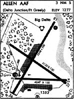
Runways
Runway Summary
| Runways: | 01/19 07/25 10/28 |
| Longest Runway: | 01/19 is 9000 ft (2743 m) long |
| Runways with an Instrument Approach: | 10 |
BIG Airport Runway Details
| Runway 01/19 | 9000 ft x 150 ft (2743 m x 46 m) | |
| Runway Length Source: | MILITARY as of 07/12/2015 | |
| Surface: | Asphalt - Good condition - No special surface treatment | |
| Runway Pavement Class: | 42 /F/A/W/T | |
| Runway Edge Lights: | High Intensity | |
Runway 01 |
Runway 19 |
|
Elevation: |
1285.2 | 1219.6 |
Latitude: |
63-59-10.9400N | 64-00-27.8400N |
Longitude: |
145-44-06.7100W | 145-42-26.5800W |
|
Runway True Alignment: |
030 | 210 |
Glide Path Angle: |
3.0 degrees | 3.0 degrees |
Traffic Pattern: |
Right | |
Runway Markings Type: |
Nonprecision Instrument | Nonprecision Instrument |
Runway Markings Condition: |
Good | Good |
Visual Glide Slope Indicators: |
4-Light PAPI On Left Side Of Runway | 4-Light PAPI On Left Side Of Runway |
Threshold Crossing Height: |
74 | 74 |
Threshold Elevation: |
1275.8 | 1226.1 |
Displaced Threshold: |
1000 | 1088 |
Threshold Latitude: |
63-59-19.4800N | 64-00-18.5434N |
Threshold Longitude: |
145-43-55.6000W | 145-42-38.6943W |
| Runway 07/25 | 4057 ft x 88 ft (1237 m x 27 m) | |
| Runway Length Source: | DOD (NGA) as of 07/12/2015 | |
| Surface: | Asphalt - Good condition - No special surface treatment | |
| Runway Pavement Class: | 42 /F/A/W/T | |
| Runway Edge Lights: | Medium Intensity | |
Runway 07 |
Runway 25 |
|
Elevation: |
1267.9 | 1257.1 |
Latitude: |
63-59-29.2800N | 63-59-27.8300N |
Longitude: |
145-43-49.1100W | 145-42-18.2300W |
|
Runway True Alignment: |
092 | 272 |
Glide Path Angle: |
0.0 degrees | 0.0 degrees |
Traffic Pattern: |
Right | |
Runway Markings Type: |
Nonprecision Instrument | Nonprecision Instrument |
Runway Markings Condition: |
Good | Good |
| Runway 10/28 | 6115 ft x 150 ft (1864 m x 46 m) | |
| Runway Length Source: | DOD (NGA) as of 07/12/2015 | |
| Surface: | Asphalt - Good condition - No special surface treatment | |
| Runway Pavement Class: | 87 /F/A/W/T | |
| Runway Edge Lights: | High Intensity | |
Runway 10 |
Runway 28 |
|
Elevation: |
1253.8 | 1256.3 |
Latitude: |
63-59-58.9600N | 63-59-24.8000N |
Longitude: |
145-44-07.7500W | 145-42-14.8800W |
|
Runway True Alignment: |
125 | 305 |
ILS Type: |
ILS/DME | |
Glide Path Angle: |
3.0 degrees | 3.0 degrees |
Runway Markings Type: |
Precision Instrument | Precision Instrument |
Runway Markings Condition: |
Good | Good |
Visual Glide Slope Indicators: |
4-Light PAPI On Left Side Of Runway | 4-Light PAPI On Left Side Of Runway |
REIL: |
Yes | Yes |
Threshold Crossing Height: |
76 | 74 |
Services
Airframe Repair: |
None |
Powerplant Repair: |
None |
Bottled Oxygen: |
None |
Bulk Oxygen: |
None |
Fuel Available: |
100LL, Jet A |
Landing Fees: |
No |
Parking: |
Tiedowns available |
Maps & Diagrams
BIG Sectional
Flight Planning
at skyvector.com
at skyvector.com