Location
Latitude: |
37-49-58.3130N (37.832865) |
Longitude: |
100-20-53.3700W (-100.348158) |
Elevation: |
2749.5 feet MSL (838 m MSL) |
Magnetic Variation: |
4.9 E (as of April 2024 from WMM2020 model) |
Time Zone: |
UTC -6.0 (Standard Time) UTC -5.0 (Daylight Savings Time) |
From City: |
02 N.M. N of Cimarron, Kansas |
Found On: |
Wichita Chart |
FAA Region: |
ACE |
Contacts
Manager: |
Publicly owned: |
| JEFF ACTON PO BOX 467 CIMARRON, KS 67835 620-855-2215 |
CITY OF CIMARRON PO BOX 467 CIMARRON, KS 67835 620-855-2215 |
Operations
Airport Status: |
Operational |
Facility Use: |
Public |
Type: |
Airport |
Activation Date: |
06/1948 |
Control tower: |
No |
Attendance (Months/Days/Hours): |
Months/Days/Hours Unattended |
Boundary ARTCC: |
ZKC (Kansas City) |
Responsible ARTCC: |
ZKC (Kansas City) |
Lighting Schedule: |
SEE RMK |
Segmented Circle Indicator: |
No |
Traffic Pattern Altitude (MSL): |
3750 feet (1143 m) |
NOTAMs Facility: |
ICT |
NOTAM-D Service: |
Yes |
Based Aircraft
| Single Engine: | 11 |
Annual Operations (as of 09/29/2020)
| Total Operations: | 3500 | |
| GA Local: | 3000 | 85.7% |
| GA Itinerant: | 500 | 14.3% |
Communications
| CTAF: | 122.900 |
Fixed Based Operators (FBOs) & Fuel
(Click on a business for detail)
Please help us keep this information up to date. This is a FREE SERVICE just like everything else on Airport Guide! If you see that a business needs to be added, modified, or deleted please fill out our Update Form.
To add, modify, or delete a business click here.
Please help us keep this information up to date. This is a FREE SERVICE just like everything else on Airport Guide! If you see that a business needs to be added, modified, or deleted please fill out our Update Form.
Area Code: 620 |
| Business Name | Frequency | Phone | Fuel Grade |
|---|
Flight Service Stations
| Primary | Alternate | |
| FSS on Field: | N | |
| FSS Name (ID): | Wichita(ICT) | |
| Frequency: | ||
| Toll Free Phone: | 1-800-WX-BRIEF |
Instrument Procedures / Charts
Terminal Procedures are only available for airports in several countries with more being added all the time. If you are looking for a specific country's charts, please send an email to support(at)airportguide.com stating the country name. This will be used to prioritize the implementation.
Navigation Aids (Navaids) near 8K8
| Dist (NM) | ID | Morse Code | Name | Type | Freq | True Hdg | Mag Hdg |
|---|---|---|---|---|---|---|---|
| 16.3 | DDC | _ . . _ . . _ . _ . | Dodge City | VORTAC | 108.20 | 86 | 81 |
| 17.8 | GC | _ _ . _ . _ . | Pieve | NDB | 347 | 269 | 264 |
| 18.6 | GCK | _ _ . _ . _ . _ . _ | Garden City | VORTAC | 113.30 | 286 | 281 |
| 46.5 | TQK | _ _ _ . _ _ . _ | Scott City | NDB | 256 | 326 | 321 |
| 50.4 | ULS | . . _ . _ . . . . . | Ulysses | NDB | 395 | 254 | 249 |
| 55.8 | LBL | . _ . . _ . . . . _ . . | Liberal | TACAN | 112.30 | 212 | 207 |
| 59.6 | LB | . _ . . _ . . . | Panck | NDB | 383 | 209 | 204 |
| 63.2 | HQG | . . . . _ _ . _ _ _ . | Hugoton | NDB | 365 | 230 | 225 |
| 63.6 | LQR | . _ . . _ _ . _ . _ . | Larned | NDB | 296 | 69 | 64 |
| 66.8 | JHN | . _ _ _ . . . . _ . | Bear Creek | NDB | 341 | 260 | 255 |
| 67.7 | BFK | _ . . . . . _ . _ . _ | Buffalo | NDB | 215 | 148 | 143 |
| 74.9 | GB | _ _ . _ . . . | Babsy | NDB | 419 | 69 | 65 |
| 75.2 | HIL | . . . . . . . _ . . | Hilyn | NDB | 338 | 64 | 60 |
| 76.2 | PTT | . _ _ . _ _ | Pratt | NDB | 356 | 94 | 90 |
| 76.3 | HY | . . . . _ . _ _ | Nette | NDB | 374 | 42 | 37 |
| 79.1 | HYS | . . . . _ . _ _ . . . | Hays | VORTAC | 110.40 | 39 | 34 |
| 79.9 | OEL | _ _ _ . . _ . . | Oakley | NDB | 380 | 344 | 339 |
| 85.7 | HLC | . . . . . _ . . _ . _ . | Hill City | VORTAC | 113.70 | 3 | 358 |
| 87.3 | GUY | _ _ . . . _ _ . _ _ | Guymon | NDB | 275 | 219 | 214 |
| 87.4 | PYX | . _ _ . _ . _ _ _ . . _ | Perryton | NDB | 266 | 192 | 187 |
Nearby Airports with Fuel
Notices to Airmen (NOTAMS)
Remarks
| A110-1 | FOR CD CTC KANSAS CITY ARTCC AT 913-254-8508. |
| A33-11/29 | TURF ROUGH & UNEVEN WITH LOW SPOTS. |
| A57-18 | APCH RATIO 50:1 AT DSPLCD THR. |
| A57-36 | APCH RATIO 24:1 AT DSPLCD THR. |
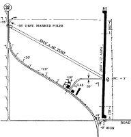
| A81-APT | ACTVT MIRL RY 18/36 - CTAF. |
| E111 | PRVDD APCHS TO ARPT ARE MAINT FOR A MIN 20:1 GLIDE SLOPE AND TRSNL SFC MAINT FOR 7:1 SLOPE. |
Runways
Runway Summary
| Runways: | 11/29 18/36 |
| Longest Runway: | 18/36 is 3200 ft (975 m) long |
| Runways with an Instrument Approach: |
8K8 Airport Runway Details
| Runway 11/29 | 1619 ft x 50 ft (493 m x 15 m) | |
| Runway Length Source: | 3RD PARTY SURVEY as of 12/19/2017 | |
| Surface: | Turf - Poor condition - No special surface treatment | |
Runway 11 |
Runway 29 |
|
Elevation: |
2749.5 | 2746.4 |
Latitude: |
37-49-58.8699N | 37-49-50.7100N |
Longitude: |
100-21-10.2900W | 100-20-52.9300W |
|
Runway True Alignment: |
121 | 301 |
Glide Path Angle: |
0.0 degrees | 0.0 degrees |
Runway Markings Condition: |
Fair | Fair |
Object at End: |
PLINE | |
Distance from End: |
20 | |
Object Centerline Offset: |
0 ft. left and right of centerline |
| Runway 18/36 | 3200 ft x 60 ft (975 m x 18 m) | |
| Runway Length Source: | 3RD PARTY SURVEY as of 03/06/2018 | |
| Surface: | Turf - Poor condition - No special surface treatment | |
| Runway Edge Lights: | Medium Intensity | |
Runway Weight Bearing Capacity (in thousands of pounds) |
||
| Single Wheel Landing Gear: | 30.0 | |
Runway 18 |
Runway 36 |
|
Elevation: |
2747.1 | 2748.6 |
Latitude: |
37-50-15.9085N | 37-49-44.2817N |
Longitude: |
100-20-49.1590W | 100-20-49.2399W |
|
Runway True Alignment: |
180 | 360 |
Glide Path Angle: |
3.0 degrees | 3.0 degrees |
Runway Markings Type: |
Nonprecision Instrument | Nonprecision Instrument |
Runway Markings Condition: |
Good | Good |
Object Centerline Offset: |
0 ft. left and right of centerline | |
Visual Glide Slope Indicators: |
2-Light PAPI On Left Side Of Runway | 2-Light PAPI On Left Side Of Runway |
REIL: |
Yes | Yes |
Threshold Crossing Height: |
44 | 44 |
Services
Airframe Repair: |
None |
Powerplant Repair: |
None |
Fuel Available: |
100LL |
Landing Fees: |
No |
Parking: |
Tiedowns available |
Maps & Diagrams
8K8 Sectional
Flight Planning
at skyvector.com
at skyvector.com