Location
Latitude: |
62-59-34.6000N (62.992944) |
Longitude: |
156-01-47.0000W (-156.029722) |
Elevation: |
423.1 feet MSL (129 m MSL) |
Magnetic Variation: |
12.3 E (as of April 2024 from WMM2020 model) |
Time Zone: |
UTC -9.0 (Standard Time) UTC -8.0 (Daylight Savings Time) |
From City: |
01 N.M. E of Takotna, Alaska |
Found On: |
Mc Grath Chart |
FAA Region: |
AAL |
Contacts
Manager: |
Publicly owned: |
| STEFFEN STRICK PO BOX 21 MC GRATH, AK 99627 907-524-3241 |
ALASKA DOT&PF CENTRAL REGION PO BOX 196900 ANCHORAGE, AK 99519-6900 (907) 269-0749 |
Operations
Airport Status: |
Operational |
Facility Use: |
Public |
Type: |
Airport |
Activation Date: |
10/1949 |
Control tower: |
No |
Attendance (Months/Days/Hours): |
Months/Days/Hours Unattended |
Boundary ARTCC: |
ZAN (Anchorage) |
Responsible ARTCC: |
ZAN (Anchorage) |
Lighting Schedule: |
SEE RMK |
Segmented Circle Indicator: |
Yes |
Traffic Pattern Altitude (MSL): |
1423 feet (434 m) |
NOTAMs Facility: |
ENA |
NOTAM-D Service: |
Yes |
International Airport of Entry: |
No |
Customs Landing Rights: |
No |
Military Landing Rights: |
Yes |
Civil/Military Joint Use: |
No |
Based Aircraft
Annual Operations (as of 12/31/2021)
| Total Operations: | 300 | |
| Air Taxi: | 300 | 100.0% |
Communications
| CTAF: | 122.900 |
Fixed Based Operators (FBOs) & Fuel
(Click on a business for detail)
Please help us keep this information up to date. This is a FREE SERVICE just like everything else on Airport Guide! If you see that a business needs to be added, modified, or deleted please fill out our Update Form.
To add, modify, or delete a business click here.
Please help us keep this information up to date. This is a FREE SERVICE just like everything else on Airport Guide! If you see that a business needs to be added, modified, or deleted please fill out our Update Form.
Area Code: 907 |
| Business Name | Frequency | Phone | Fuel Grade |
|---|
Flight Service Stations
| Primary | Alternate | |
| FSS on Field: | N | |
| FSS Name (ID): | Kenai(ENA) | |
| Frequency: | ||
| Toll Free Phone: | 1-866-864-1737 |
Instrument Procedures / Charts
Terminal Procedures are only available for airports in several countries with more being added all the time. If you are looking for a specific country's charts, please send an email to support(at)airportguide.com stating the country name. This will be used to prioritize the implementation.
Navigation Aids (Navaids) near TCT
Nearby Airports with Fuel
| Dist (NM) | Name (Airport IDs) | True Hdg | Mag Hdg | Fuel Grade |
|---|---|---|---|---|
| 11.8 | Mc Grath Airport (MCG PAMC MCG) |
101 | 89 | 100LL, Jet A-1+ |
| 89.2 | Crooked Creek Airport (CKD CJX) |
221 | 210 | MOGAS |
Notices to Airmen (NOTAMS)
Remarks
| A110-2 | RWY CONDITION NOT MONITORED; RECOMMEND VISUAL INSPECTION BEFORE USING. |
| A110-3 | WX CAMERA AVBL ON INTERNET AT HTTPS://WEATHERCAMS.FAA.GOV. |
| A33-04/22 | RWY 04/22 MULTIPLE LATERAL CRACKS FULL LENGTH AND WIDTH OF RWY. UNEVEN SURFACE, DIPS, HEAVES AND HUMPS FULL LENGTH AND WIDTH OF RWY. |
| A42-04 | RY 04/22 NSTD MKGS: RY MKD WITH REFLECTIVE CONES AND MARKERS. |
| A81-APT | ACTVT MIRL RY 04/22 - CTAF. |
| A81-BCN | ACTVT ROTG BCN - CTAF. |
| E111 | ESTABD PRIOR TO 1959. |
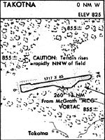
Runways
Runway Summary
| Runways: | 04/22 |
| Longest Runway: | 04/22 is 3300 ft (1006 m) long |
| Runways with an Instrument Approach: |
TCT Airport Runway Details
| Runway 04/22 | 3300 ft x 60 ft (1006 m x 18 m) | |
| Runway Length Source: | STATE as of 01/16/2014 | |
| Surface: | Gravel - Poor condition - No special surface treatment | |
| Runway Edge Lights: | Medium Intensity | |
Runway 04 |
Runway 22 |
|
Elevation: |
419.9 | 422.6 |
Latitude: |
62-59-25.1000N | 62-59-44.0000N |
Longitude: |
156-02-16.0000W | 156-01-18.0000W |
Glide Path Angle: |
0.0 degrees | 0.0 degrees |
Traffic Pattern: |
Left | Left |
Runway Markings Type: |
Nonstandard (other than numbers only) | Nonstandard (other than numbers only) |
Services
Fuel Available: |
MOGAS |
Landing Fees: |
No |
Maps & Diagrams
TCT Sectional
Flight Planning
at skyvector.com
at skyvector.com