Location
Latitude: |
32-39-37.0512N (32.660292) |
Longitude: |
107-11-43.4721W (-107.195409) |
Elevation: |
4128.9 feet MSL (1258 m MSL) |
Magnetic Variation: |
7.9 E (as of April 2024 from WMM2020 model) |
Time Zone: |
UTC -7.0 (Standard Time) UTC -6.0 (Daylight Savings Time) |
From City: |
03 N.M. SW of Hatch, New Mexico |
Found On: |
Albuquerque Chart |
FAA Region: |
ASW |
Contacts
Manager: |
Publicly owned: |
| JIM WHITLOCK P.O. BOX 220 HATCH, NM 87937 575-649-6211 |
VILLAGE OF HATCH BOX 220 HATCH, NM 87937 575-644-1282 |
Operations
Airport Status: |
Operational |
Facility Use: |
Public |
Type: |
Airport |
Activation Date: |
02/1953 |
Control tower: |
No |
Attendance (Months/Days/Hours): |
Months/Days/Hours Unattended |
Boundary ARTCC: |
ZAB (Albuquerque) |
Responsible ARTCC: |
ZAB (Albuquerque) |
Lighting Schedule: |
SEE RMK |
Segmented Circle Indicator: |
No |
Traffic Pattern Altitude (MSL): |
5129 feet (1563 m) |
NOTAMs Facility: |
ABQ |
NOTAM-D Service: |
Yes |
International Airport of Entry: |
No |
Customs Landing Rights: |
No |
Military Landing Rights: |
Yes |
Civil/Military Joint Use: |
No |
Based Aircraft
Annual Operations (as of 04/07/2023)
| Total Operations: | 2500 | |
| GA Local: | 2250 | 90.0% |
| GA Itinerant: | 150 | 6.0% |
| Military Aircraft: | 100 | 4.0% |
Communications
| CTAF: | 122.900 |
Fixed Based Operators (FBOs) & Fuel
(Click on a business for detail)
Please help us keep this information up to date. This is a FREE SERVICE just like everything else on Airport Guide! If you see that a business needs to be added, modified, or deleted please fill out our Update Form.
To add, modify, or delete a business click here.
Please help us keep this information up to date. This is a FREE SERVICE just like everything else on Airport Guide! If you see that a business needs to be added, modified, or deleted please fill out our Update Form.
Area Code: 505 |
| Business Name | Frequency | Phone | Fuel Grade |
|---|
Flight Service Stations
| Primary | Alternate | |
| FSS on Field: | N | |
| FSS Name (ID): | Albuquerque(ABQ) | |
| Frequency: | ||
| Toll Free Phone: | 1-800-WX-BRIEF |
Instrument Procedures / Charts
Terminal Procedures are only available for airports in several countries with more being added all the time. If you are looking for a specific country's charts, please send an email to support(at)airportguide.com stating the country name. This will be used to prioritize the implementation.
Navigation Aids (Navaids) near E05
| Dist (NM) | ID | Morse Code | Name | Type | Freq | True Hdg | Mag Hdg |
|---|---|---|---|---|---|---|---|
| 31.0 | DMN | _ . . _ _ _ . | Deming | VORTAC | 108.60 | 222 | 214 |
| 37.6 | TCS | _ _ . _ . . . . | Truth Or Consequences | VORTAC | 112.70 | 353 | 345 |
| 43.9 | SV | . . . . . . _ | Cozey | NDB | 251 | 268 | 260 |
| 48.8 | SVC | . . . . . . _ _ . _ . | Silver City | VOR-DME | 110.80 | 268 | 260 |
| 54.0 | CUS | _ . _ . . . _ . . . | Columbus | VOR-DME | 111.20 | 200 | 192 |
| 56.1 | HMN | . . . . _ _ _ . | Holloman | TACAN | 114.50 | 77 | 69 |
| 60.4 | BWS | _ . . . . _ _ . . . | Boles | DME | 113.65 | 80 | 72 |
| 63.2 | EWM | . . _ _ _ _ | Newman | VORTAC | 112.40 | 132 | 124 |
| 65.5 | EL | . . _ . . | Valtr | NDB | 242 | 136 | 128 |
| 66.4 | ELP | . . _ . . . _ _ . | El Paso | VOT | 111.00 | 140 | 132 |
| 68.7 | ELP | . . _ . . . _ _ . | El Paso | VORTAC | 115.20 | 137 | 129 |
| 72.8 | CJS | Juarez | VOR-DME | 116.70 | 147 | 139 | |
| 72.8 | CJS | _ . _ . . _ _ _ . . . | Ciudad Juarez | VOR-DME | 116.70 | 147 | 139 |
| 95.9 | PIO | . _ _ . . . _ _ _ | Pinon | VOR-DME | 110.40 | 94 | 87 |
Nearby Airports with Fuel
| Dist (NM) | Name (Airport IDs) | True Hdg | Mag Hdg | Fuel Grade |
|---|---|---|---|---|
| 26.2 | Las Cruces International Airport (LRU KLRU LRU) |
148 | 140 | 100LL, Jet A-1+ |
| 34.7 | Truth Or Consequences Municipal Airport (TCS KTCS TCS) |
353 | 345 | 100LL, Jet A-1+ |
| 35.7 | Deming Municipal Airport (DMN KDMN DMN) |
228 | 220 | 100LL, Jet A-1+ |
| 48.6 | Grant County Airport (SVC KSVC SVC) |
268 | 260 | 100LL, Jet A-1 |
| 51.5 | Whiskey Creek Airport (94E) |
277 | 269 | 100LL, Jet A |
| 53.0 | Dona Ana County International Jetport Airport (DNA) |
151 | 143 | 100LL, Jet A-1+ |
| 61.7 | Alamogordo-White Sands Regional Airport (ALM KALM ALM) |
79 | 72 | 100LL, Jet A-1+ |
| 65.9 | El Paso International Airport (ELP KELP ELP) |
140 | 133 | 100LL, Jet A-1+ |
| 78.2 | Lordsburg Municipal Airport (LSB KLSB LSB) |
255 | 247 | 100LL, Jet A-1+ |
| 83.0 | Socorro Municipal Airport (ONM KONM ONM) |
10 | 2 | 100LL |
| 86.9 | Fabens Airport (E35) |
141 | 134 | 100LL |
| 88.2 | Carrizozo Municipal Airport (F37) |
47 | 40 | 100LL |
| 96.5 | Sierra Blanca Regional Airport (RUI KSRR SRR) |
59 | 52 | 100LL, Jet A |
Notices to Airmen (NOTAMS)
Remarks
| A11 | ELIZABETH PORRAS |
| A110-2 | ACES GATE CODE - #4080#. |
| A110-4 | FOR CD CTC ALBUQUERQUE ARTCC AT 505-856-4861. |
| A16 | EMERG - 575-649-6211 |
| A43-11 | APAP LGTD; OTS INDEF. |
| A43-29 | APAP LGTD; OTS INDEF. |
| A49-11 | NSTD ODALS; OTS INDEF. |
| A49-29 | NSTD ODALS. |
| A58-11 | 4-6 FT BRUSH 0-200 FT FM THR 80 FT R. |
| A81-APT | ACTVT ODALS RWY 11 & 29 - CTAF. |
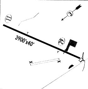
Runways
Runway Summary
| Runways: | 11/29 |
| Longest Runway: | 11/29 is 4110 ft (1253 m) long |
| Runways with an Instrument Approach: |
E05 Airport Runway Details
| Runway 11/29 | 4110 ft x 60 ft (1253 m x 18 m) | |
| Runway Length Source: | STATE as of 05/27/2003 | |
| Surface: | Asphalt - Good condition - No special surface treatment | |
| Runway Pavement Class: | 3 /F/D/Y/T | |
Runway Weight Bearing Capacity (in thousands of pounds) |
||
| Single Wheel Landing Gear: | 9.0 | |
Runway 11 |
Runway 29 |
|
Elevation: |
4128.9 | 4124.9 |
Latitude: |
32-39-44.7700N | 32-39-29.3324N |
Longitude: |
107-12-05.7017W | 107-11-21.2424W |
|
Runway True Alignment: |
112 | 292 |
Glide Path Angle: |
0.0 degrees | 0.0 degrees |
Traffic Pattern: |
Left | Left |
Runway Markings Type: |
Basic | Basic |
Runway Markings Condition: |
Fair | Fair |
Visual Glide Slope Indicators: |
Approach Path Alignment Panels (APAP) On Left Side Of Runway | Approach Path Alignment Panels (APAP) On Left Side Of Runway |
Approach Light System: |
Nonstandard | Nonstandard |
Services
Powerplant Repair: |
Major |
Bottled Oxygen: |
High Pressure |
Fuel Available: |
100LL, Jet A |
Parking: |
Hangars and tiedowns available |
Maps & Diagrams
E05 Sectional
Flight Planning
at skyvector.com
at skyvector.com