Location
Latitude: |
32-17-21.8900N (32.289414) |
Longitude: |
106-55-19.0720W (-106.921964) |
Elevation: |
4456.9 feet MSL (1358 m MSL) |
Magnetic Variation: |
7.8 E (as of April 2024 from WMM2020 model) |
Time Zone: |
UTC -7.0 (Standard Time) UTC -6.0 (Daylight Savings Time) |
From City: |
08 N.M. W of Las Cruces, New Mexico |
Found On: |
Albuquerque Chart |
FAA Region: |
ASW |
Contacts
Manager: |
Publicly owned: |
| ANDY HUME PO BOX 20000 LAS CRUCES, NM 88004 (575) 541-2473 |
CITY OF LAS CRUCES PO BOX 20000 LAS CRUCES, NM 88004 (575) 541-2471 |
Operations
Airport Status: |
Operational |
Facility Use: |
Public |
Type: |
Airport |
Activation Date: |
02/1943 |
Control tower: |
No |
Attendance (Months/Days/Hours): |
Months/Days/Hours ALL/ALL/ALL |
Boundary ARTCC: |
ZAB (Albuquerque) |
Responsible ARTCC: |
ZAB (Albuquerque) |
Lighting Schedule: |
SEE RMK |
Segmented Circle Indicator: |
Yes |
Traffic Pattern Altitude (MSL): |
5457 feet (1663 m) |
NOTAMs Facility: |
LRU |
NOTAM-D Service: |
Yes |
International Airport of Entry: |
No |
Customs Landing Rights: |
No |
Military Landing Rights: |
Yes |
Civil/Military Joint Use: |
No |
Aircraft Rescue and Firefighting: |
Class IV ARFF Index: A Air Carrier Service: Not Scheduled Certification Date: 01/1981 |
Based Aircraft
| Single Engine: | 82 |
| Multi Engine: | 10 |
| Jet Engine: | 2 |
| GA Helicopters: | 3 |
| Gliders: | 4 |
| Military Aircraft: | 4 |
| Ultralights: | 1 |
Annual Operations (as of 12/31/2019)
| Total Operations: | 36825 | |
| Air Taxi: | 3634 | 9.9% |
| GA Local: | 12180 | 33.1% |
| GA Itinerant: | 10658 | 28.9% |
| Military Aircraft: | 10353 | 28.1% |
Communications
| CTAF: | 122.700 |
| Unicom: | 122.700 |
| AWOS-3: | 119.025 (575-526-4831) |
- APCH/DEP SVC PRVDD BY ALBUQUERQUE ARTCC (ABQ) ON FREQS 128.2/285.5 (EL PASO/B/ RCAG).
Fixed Based Operators (FBOs) & Fuel
(Click on a business for detail)
Please help us keep this information up to date. This is a FREE SERVICE just like everything else on Airport Guide! If you see that a business needs to be added, modified, or deleted please fill out our Update Form.
To add, modify, or delete a business click here.
Please help us keep this information up to date. This is a FREE SERVICE just like everything else on Airport Guide! If you see that a business needs to be added, modified, or deleted please fill out our Update Form.
Area Code: 505 |
| Business Name | Frequency | Phone | Fuel Grade |
|---|---|---|---|
| Adventure Aviation
Website Update FBO info |
525-0500, 877-525-0500 | 100LL, Jet A | |

|
Air Bp | 100LL - 2.29 USD per gallon on 10/18/01 |
Trucks Discount on 500 gallons or more per visit per aircraft. For further information contact Bob Reich. |
|
|
Air Bp | Jet A - 1.79 USD per gallon on 10/18/01 |
Trucks Discount on 500 gallons or more per visit per aircraft. For further information contact Bob Reich. |
| Francis Aviation
Website Update FBO info |
122.7 | 575-526-6341 | 100LL, Jet A |
|
|
Unknown | 100LL - 5.50 USD per gallon on 12/2/14 |
Trucks |
|
|
Unknown | Jet A - 4.89 USD per gallon on 12/2/14 |
Trucks with Prist |
| Mesa Airlines
Update FBO info |
800-637-2247, 526-9743 | ||
| Southwest Aviation, Inc.
Update FBO info |
Unicom 122.7 | 524-8047 | 100LL, Jet A |
Flight Service Stations
| Primary | Alternate | |
| FSS on Field: | N | |
| FSS Name (ID): | Albuquerque(ABQ) | |
| Frequency: | ||
| Toll Free Phone: | 1-800-WX-BRIEF |
Instrument Procedures / Charts
FAA Terminal Procedures valid from 0901Z 03/21/24 to 0901Z 04/18/24.
There are various types of charts available for an airport. They are listed in the Page Type column. Here is a legend for those types:
APD - Airport Diagram
DP - Departure Procedure Charts
HOT - Hot Spots
IAP - Instrument Approach Procedure Charts
MIN - Minimums
STAR - Standard Terminal Arrival Charts
| Page Type | Page Name | Volume | Action Since Last Cycle |
|---|---|---|---|
| APD | AIRPORT DIAGRAM | SW-1 | |
| IAP | ILS OR LOC RWY 30 | SW-1 | |
| IAP | RNAV (GPS) RWY 12 | SW-1 | |
| IAP | RNAV (GPS) RWY 30 | SW-1 | |
| MIN | ALTERNATE MINIMUMS | SW-1 | |
| MIN | TAKEOFF MINIMUMS | SW-1 |
Terminal Procedures are only available for airports in several countries with more being added all the time. If you are looking for a specific country's charts, please send an email to support(at)airportguide.com stating the country name. This will be used to prioritize the implementation.
Navigation Aids (Navaids) near LRU
| Dist (NM) | ID | Morse Code | Name | Type | Freq | True Hdg | Mag Hdg |
|---|---|---|---|---|---|---|---|
| 34.7 | DMN | _ . . _ _ _ . | Deming | VORTAC | 108.60 | 268 | 260 |
| 38.7 | EWM | . . _ _ _ _ | Newman | VORTAC | 112.40 | 121 | 113 |
| 40.1 | EL | . . _ . . | Valtr | NDB | 242 | 129 | 121 |
| 40.6 | ELP | . . _ . . . _ _ . | El Paso | VOT | 111.00 | 135 | 127 |
| 43.2 | ELP | . . _ . . . _ _ . | El Paso | VORTAC | 115.20 | 130 | 122 |
| 43.6 | CUS | _ . _ . . . _ . . . | Columbus | VOR-DME | 111.20 | 229 | 221 |
| 46.6 | CJS | Juarez | VOR-DME | 116.70 | 147 | 139 | |
| 46.6 | CJS | _ . _ . . _ _ _ . . . | Ciudad Juarez | VOR-DME | 116.70 | 147 | 139 |
| 53.6 | HMN | . . . . _ _ _ . | Holloman | TACAN | 114.50 | 49 | 41 |
| 56.0 | BWS | _ . . . . _ _ . . . | Boles | DME | 113.65 | 54 | 46 |
| 61.3 | SV | . . . . . . _ | Cozey | NDB | 251 | 289 | 281 |
| 62.3 | TCS | _ _ . _ . . . . | Truth Or Consequences | VORTAC | 112.70 | 343 | 335 |
| 66.1 | SVC | . . . . . . _ _ . _ . | Silver City | VOR-DME | 110.80 | 288 | 280 |
| 83.1 | PIO | . _ _ . . . _ _ _ | Pinon | VOR-DME | 110.40 | 79 | 72 |
| 89.8 | HUP | . . . . . . _ . _ _ . | Hudspeth | VORTAC | 115.00 | 118 | 111 |
| 98.8 | SFL | . . . . . _ . . _ . . | Salt Flat | VORTAC | 113.00 | 108 | 101 |
Nearby Airports with Fuel
| Dist (NM) | Name (Airport IDs) | True Hdg | Mag Hdg | Fuel Grade |
|---|---|---|---|---|
| 26.9 | Dona Ana County International Jetport Airport (DNA) |
155 | 147 | 100LL, Jet A-1+ |
| 40.1 | El Paso International Airport (ELP KELP ELP) |
136 | 129 | 100LL, Jet A-1+ |
| 40.5 | Deming Municipal Airport (DMN KDMN DMN) |
267 | 259 | 100LL, Jet A-1+ |
| 57.5 | Alamogordo-White Sands Regional Airport (ALM KALM ALM) |
54 | 47 | 100LL, Jet A-1+ |
| 59.4 | Truth Or Consequences Municipal Airport (TCS KTCS TCS) |
342 | 334 | 100LL, Jet A-1+ |
| 60.9 | Fabens Airport (E35) |
139 | 132 | 100LL |
| 65.9 | Grant County Airport (SVC KSVC SVC) |
288 | 280 | 100LL, Jet A-1 |
| 71.0 | Whiskey Creek Airport (94E) |
293 | 285 | 100LL, Jet A |
| 89.8 | Lordsburg Municipal Airport (LSB KLSB LSB) |
272 | 264 | 100LL, Jet A-1+ |
| 96.5 | Carrizozo Municipal Airport (F37) |
32 | 25 | 100LL |
| 99.3 | Sierra Blanca Regional Airport (RUI KSRR SRR) |
44 | 37 | 100LL, Jet A |
Notices to Airmen (NOTAMS)
Remarks
| A110-2 | BIRDS ON & INVOF ARPT SEP-MAR. UAS TRNG ON ARPT. |
| A110-7 | UAS TRNG & FOR CD CTC ALBUQUERQUE ARTCC AT 505-856-4861. |
| A26 | 48 HR PPR FOR ACR ACFT WITH MORE THAN 30 PAX SEATS - 575-541-2471/2473. |
| A30-04/22 | ACR & ACFT OVER 30000 LBS NA. |
| A30-12/30 | RWY 30 CALM WIND RWY. |
| A33-04/22 | BLOCK CRACKING UP TO 3 IN WIDE CRACKS, RAVELING, AND WEATHERING. |
| A81-APT | ACTVT MALSR RWY 30; MIRL RWY 04/22 & 8/26; HIRL RWY 12/30 - CTAF. REIL RWY 12 SS-SR. PAPI RWY 08, 26 & VASI RWY 22 ON CONSLY. MIRL RWY 08/26 PRESET LOW INTST; INCR INTST - CTAF. |
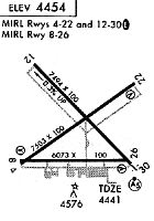
Runways
Runway Summary
| Runways: | 04/22 08/26 12/30 |
| Longest Runway: | 12/30 is 7506 ft (2288 m) long |
| Runways with an Instrument Approach: | 30 |
LRU Airport Runway Details
| Runway 04/22 | 7501 ft x 105 ft (2286 m x 32 m) | |
| Runway Length Source: | 3RD PARTY SURVEY as of 08/08/2022 | |
| Surface: | Asphalt - Poor condition - No special surface treatment | |
| Runway Pavement Class: | 3 /F/D/Y/T | |
| Runway Edge Lights: | Medium Intensity | |
Runway Weight Bearing Capacity (in thousands of pounds) |
||
| Single Wheel Landing Gear: | 30.0 | |
| Dual Wheel Landing Gear: | 30.0 | |
| Dual Tandem Wheel Landing Gear: | 30.0 | |
| Dual Dual Tandem Wheel Landing Gear: | 30.0 | |
Runway 04 |
Runway 22 |
|
Elevation: |
4436.0 | 4451.8 |
Latitude: |
32-17-04.4742N | 32-17-47.4074N |
Longitude: |
106-55-55.5660W | 106-54-44.3202W |
|
Runway True Alignment: |
055 | 235 |
Glide Path Angle: |
0.0 degrees | 3.0 degrees |
Traffic Pattern: |
Left | Left |
Runway Markings Type: |
Basic | Basic |
Runway Markings Condition: |
Fair | Fair |
Visual Glide Slope Indicators: |
4-Box VASI On Left Side Of Runway | |
Threshold Crossing Height: |
48 | |
Declared Distances |
||
Take Off Run Avbl. (TORA): |
7499 | 7499 |
Take Off Distance Avbl. (TODA): |
7499 | 7499 |
Actual Stop Dist. Avbl. (ASDA): |
7499 | 7499 |
Landing Dist. Avbl. (LDA): |
7499 | 7499 |
| Runway 08/26 | 6069 ft x 100 ft (1850 m x 30 m) | |
| Runway Length Source: | 3RD PARTY SURVEY as of 08/08/2022 | |
| Surface: | Asphalt - Poor condition - No special surface treatment | |
| Runway Pavement Class: | 25 /F/C/X/T | |
| Runway Edge Lights: | Medium Intensity | |
Runway Weight Bearing Capacity (in thousands of pounds) |
||
| Single Wheel Landing Gear: | 70.0 | |
| Dual Wheel Landing Gear: | 120.0 | |
Runway 08 |
Runway 26 |
|
Elevation: |
4436.6 | 4435.9 |
Latitude: |
32-17-05.8254N | 32-17-05.8455N |
Longitude: |
106-55-56.0496W | 106-54-45.3725W |
|
Runway True Alignment: |
090 | 270 |
Glide Path Angle: |
3.0 degrees | 3.0 degrees |
Traffic Pattern: |
Left | Left |
Runway Markings Type: |
Basic | Basic |
Runway Markings Condition: |
Good | Fair |
Visual Glide Slope Indicators: |
4-Light PAPI On Left Side Of Runway | 4-Light PAPI On Left Side Of Runway |
Threshold Crossing Height: |
50 | 50 |
Declared Distances |
||
Take Off Run Avbl. (TORA): |
6069 | 6069 |
Take Off Distance Avbl. (TODA): |
6069 | 6069 |
Actual Stop Dist. Avbl. (ASDA): |
6069 | 6069 |
Landing Dist. Avbl. (LDA): |
6069 | 6069 |
| Runway 12/30 | 7506 ft x 100 ft (2288 m x 30 m) | |
| Runway Length Source: | 3RD PARTY SURVEY as of 08/08/2022 | |
| Surface: | Asphalt - Poor condition - Saw-cut or plastic grooved | |
| Runway Pavement Class: | 41 /R/B/W/T | |
| Runway Edge Lights: | High Intensity | |
Runway Weight Bearing Capacity (in thousands of pounds) |
||
| Single Wheel Landing Gear: | 70.0 | |
| Dual Wheel Landing Gear: | 120.0 | |
Runway 12 |
Runway 30 |
|
Elevation: |
4456.9 | 4436.0 |
Latitude: |
32-17-57.0749N | 32-17-04.5631N |
Longitude: |
106-55-47.7788W | 106-54-45.9743W |
|
Runway True Alignment: |
135 | 315 |
ILS Type: |
ILS/DME | |
Glide Path Angle: |
0.0 degrees | 0.0 degrees |
Traffic Pattern: |
Left | Left |
Runway Markings Type: |
Nonprecision Instrument | Precision Instrument |
Runway Markings Condition: |
Good | Good |
Approach Light System: |
1,400 Foot Medium Intensity Approach Lighting System With Runway Alignment Indicator Lights | |
REIL: |
Yes | |
Declared Distances |
||
Take Off Run Avbl. (TORA): |
7506 | 7506 |
Take Off Distance Avbl. (TODA): |
7506 | 7506 |
Actual Stop Dist. Avbl. (ASDA): |
7506 | 7500 |
Landing Dist. Avbl. (LDA): |
7506 | 7500 |
Services
Powerplant Repair: |
Major |
Bottled Oxygen: |
High Pressure |
Fuel Available: |
100LL, Jet A |
Parking: |
Hangars and tiedowns available |
Maps & Diagrams
LRU Sectional
Flight Planning
at skyvector.com
at skyvector.com