Location
Latitude: |
32-51-40.8000N (32.861333) |
Longitude: |
094-00-36.5530W (-94.010154) |
Elevation: |
260.0 feet MSL (79 m MSL) |
Magnetic Variation: |
1 E (as of May 2024 from WMM2020 model) |
Time Zone: |
UTC -6.0 (Standard Time) UTC -5.0 (Daylight Savings Time) |
From City: |
02 N.M. SW of Vivian, Louisiana |
Found On: |
Memphis Chart |
FAA Region: |
ASW |
Contacts
Manager: |
Publicly owned: |
| MR. MARTY MUSICK P. O. BOX 648 VIVIAN, LA 71082 (318) 455-5499 |
TOWN OF VIVIAN P. O. BOX 832 VIVIAN, LA 71082 318-375-3856 |
Operations
Airport Status: |
Operational |
Facility Use: |
Public |
Type: |
Airport |
Activation Date: |
02/1960 |
Control tower: |
No |
Attendance (Months/Days/Hours): |
Months/Days/Hours ALL/MON-SAT/DAWN-DUSK |
Boundary ARTCC: |
ZFW (Fort Worth) |
Responsible ARTCC: |
ZFW (Fort Worth) |
Lighting Schedule: |
SEE RMK |
Segmented Circle Indicator: |
No |
Traffic Pattern Altitude (MSL): |
1260 feet (384 m) |
NOTAMs Facility: |
DRI |
NOTAM-D Service: |
Yes |
International Airport of Entry: |
No |
Customs Landing Rights: |
No |
Civil/Military Joint Use: |
No |
Based Aircraft
| Single Engine: | 10 |
| GA Helicopters: | 1 |
Annual Operations (as of 11/15/2023)
| Total Operations: | 11012 | |
| GA Local: | 3000 | 27.2% |
| GA Itinerant: | 8000 | 72.6% |
| Military Aircraft: | 12 | 0.1% |
Communications
| CTAF: | 122.800 |
| Unicom: | 122.800 |
| Approach: | SHREVEPORT 119.9 119.9 |
| Departure: | SHREVEPORT 119.9 119.9 |
Fixed Based Operators (FBOs) & Fuel
(Click on a business for detail)
Please help us keep this information up to date. This is a FREE SERVICE just like everything else on Airport Guide! If you see that a business needs to be added, modified, or deleted please fill out our Update Form.
To add, modify, or delete a business click here.
Please help us keep this information up to date. This is a FREE SERVICE just like everything else on Airport Guide! If you see that a business needs to be added, modified, or deleted please fill out our Update Form.
Area Code: 318 |
| Business Name | Frequency | Phone | Fuel Grade |
|---|
Flight Service Stations
| Primary | Alternate | |
| FSS on Field: | N | |
| FSS Name (ID): | De Ridder(DRI) | |
| Frequency: | ||
| Toll Free Phone: | 1-800-WX-BRIEF |
Instrument Procedures / Charts
FAA Terminal Procedures valid from 0901Z 05/16/24 to 0901Z 06/13/24.
There are various types of charts available for an airport. They are listed in the Page Type column. Here is a legend for those types:
APD - Airport Diagram
DP - Departure Procedure Charts
HOT - Hot Spots
IAP - Instrument Approach Procedure Charts
MIN - Minimums
STAR - Standard Terminal Arrival Charts
| Page Type | Page Name | Volume | Action Since Last Cycle |
|---|---|---|---|
| IAP | RNAV (GPS) RWY 09 | SC-4 | |
| IAP | RNAV (GPS) RWY 27 | SC-4 | |
| IAP | VOR/DME-A | SC-4 | |
| MIN | TAKEOFF MINIMUMS | SC-4 |
Terminal Procedures are only available for airports in several countries with more being added all the time. If you are looking for a specific country's charts, please send an email to support(at)airportguide.com stating the country name. This will be used to prioritize the implementation.
Navigation Aids (Navaids) near 3F4
| Dist (NM) | ID | Morse Code | Name | Type | Freq | True Hdg | Mag Hdg |
|---|---|---|---|---|---|---|---|
| 0.1 | VIV | . . . _ . . . . . _ | Vivian | NDB | 284 | 181 | 180 |
| 11.4 | EIC | . . . _ . _ . | Belcher | VORTAC | 117.40 | 118 | 117 |
| 17.2 | ATA | . _ _ . _ | Atlanta | NDB | 347 | 328 | 327 |
| 23.6 | DTN | _ . . _ _ . | Downtown | VOR | 108.60 | 144 | 143 |
| 26.3 | SHV | . . . . . . . . . . _ | Shreveport | VOT | 108.20 | 160 | 159 |
| 27.6 | BAD | _ . . . . _ _ . . | Barksdale | TACAN | 115.80 | 141 | 140 |
| 34.7 | EMG | . _ _ _ _ . | Elm Grove | VORTAC | 111.20 | 142 | 141 |
| 39.3 | TXK | _ _ . . _ _ . _ | Texarkana | VORTAC | 116.30 | 355 | 354 |
| 40.1 | TX | _ _ . . _ | Tecco | NDB | 234 | 7 | 6 |
| 43.4 | RPF | . _ . . _ _ . . . _ . | Carthage | NDB | 332 | 199 | 198 |
| 46.0 | GGG | _ _ . _ _ . _ _ . | Gregg County | VORTAC | 112.90 | 234 | 233 |
| 46.6 | GG | _ _ . _ _ . | Veels | NDB | 410 | 238 | 237 |
| 49.4 | MSD | _ _ . . . _ . . | Mansfield | NDB | 414 | 165 | 164 |
| 54.5 | HPC | . . . . . _ _ . _ . _ . | Hope | NDB | 362 | 19 | 18 |
| 58.1 | ABG | . _ _ . . . _ _ . | Ambassador | NDB | 404 | 253 | 252 |
| 59.0 | HNO | . . . . _ . _ _ _ | Henderson | NDB | 371 | 227 | 226 |
| 62.1 | CZJ | _ . _ . _ _ . . . _ _ _ | Amason | NDB | 341 | 186 | 185 |
| 67.9 | ELD | . . _ . . _ . . | El Dorado | VOR-DME | 115.50 | 69 | 68 |
| 68.4 | UIM | . . _ . . _ _ | Quitman | DME | 114 | 271 | 270 |
| 69.3 | EL | . . _ . . | Lados | NDB | 418 | 68 | 67 |
Nearby Airports with Fuel
Notices to Airmen (NOTAMS)
Remarks
| A110*G | THIS AIRPORT HAS BEEN SURVEYED BY THE NATIONAL GEODETIC SURVEY. |
| A110-1 | GCO AVBL ON FREQ 135.075 THRU BAD APCH CTL AND FLT SVCS. |
| A110-3 | FOR CD IF UNA VIA GCO CTC FORT WORTH ARTCC AT 817-858-7584. |
| A43-09 | RWY 09 PAPI OUT OF SERVICE |
| A48-27 | RWY 27 REIL OTS |
| A70-FUEL-10 | 0LL FUEL AVBL 24 HRS SELF SVC WITH CREDIT CARD. |
| A81-APT | MIRL RY 09/27 AND REIL RY 09 PRESET LOW INTST DUSK-DAWN; TO INCR INTST ACTVT - CTAF. |
Runways
Runway Summary
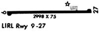
| Runways: | 09/27 |
| Longest Runway: | 09/27 is 2998 ft (914 m) long |
| Runways with an Instrument Approach: |
3F4 Airport Runway Details
| Runway 09/27 | 2998 ft x 75 ft (914 m x 23 m) | |
| Surface: | Asphalt - Good condition - No special surface treatment | |
| Runway Edge Lights: | Medium Intensity | |
Runway Weight Bearing Capacity (in thousands of pounds) |
||
| Single Wheel Landing Gear: | 12.0 | |
Runway 09 |
Runway 27 |
|
Elevation: |
247.0 | 259.0 |
Latitude: |
32-51-40.6970N | 32-51-40.8910N |
Longitude: |
094-00-54.1240W | 094-00-18.9760W |
|
Runway True Alignment: |
090 | 270 |
Glide Path Angle: |
3.0 degrees | 0.0 degrees |
Traffic Pattern: |
Left | Left |
Runway Markings Type: |
Nonprecision Instrument | Nonprecision Instrument |
Runway Markings Condition: |
Good | Good |
Object at End: |
TREES | TREES |
Object Height: |
27 | 106 |
Distance from End: |
720 | 2392 |
Object Centerline Offset: |
62 ft. left of centerline | 208 ft. right of centerline |
Visual Glide Slope Indicators: |
2-Light PAPI On Left Side Of Runway | |
REIL: |
Yes | Yes |
Threshold Crossing Height: |
52 |
Services
Airframe Repair: |
None |
Powerplant Repair: |
None |
Bottled Oxygen: |
None |
Fuel Available: |
100LL, Jet A |
Landing Fees: |
No |
Parking: |
Hangars and tiedowns available |
Maps & Diagrams
3F4 Sectional
Flight Planning
at skyvector.com
at skyvector.com