Location
Latitude: |
61-24-57.9150N (61.416088) |
Longitude: |
149-30-29.9152W (-149.50831) |
Elevation: |
83.0 feet MSL (25 m MSL) |
Magnetic Variation: |
14.9 E (as of April 2024 from WMM2020 model) |
Time Zone: |
UTC -9.0 (Standard Time) UTC -8.0 (Daylight Savings Time) |
From City: |
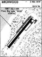
02 N.M. NW of Birchwood, Alaska |
Found On: |
Anchorage Chart |
FAA Region: |
AAL |
Contacts
Manager: |
Publicly owned: |
| KAYCE ELIASON 5300 E. TUDOR ROAD, STATE OF ALASKA DOTPF CR ANCHORAGE, AK 99507-1249 907-338-1466 |
ALASKA DOT&PF CENTRAL REGION PO BOX 196900 ANCHORAGE, AK 99519-6900 (907) 338-1466 |
Operations
Airport Status: |
Operational |
Facility Use: |
Public |
Type: |
Airport |
Activation Date: |
10/1949 |
Control tower: |
No |
Attendance (Months/Days/Hours): |
Months/Days/Hours Unattended |
Boundary ARTCC: |
ZAN (Anchorage) |
Responsible ARTCC: |
ZAN (Anchorage) |
Lighting Schedule: |
SEE RMK |
Segmented Circle Indicator: |
Yes |
Traffic Pattern Altitude (MSL): |
1083 feet (330 m) |
NOTAMs Facility: |
BCV |
NOTAM-D Service: |
Yes |
Based Aircraft
| Single Engine: | 301 |
| Multi Engine: | 6 |
| GA Helicopters: | 1 |
| Gliders: | 1 |
Annual Operations (as of 12/31/2019)
| Total Operations: | 70188 | |
| GA Local: | 35044 | 49.9% |
| GA Itinerant: | 35044 | 49.9% |
| Military Aircraft: | 100 | 0.1% |
Communications
| CTAF: | 123.000 |
| AWOS-3P: | 135.55 (907-688-0826) |
Fixed Based Operators (FBOs) & Fuel
(Click on a business for detail)
Please help us keep this information up to date. This is a FREE SERVICE just like everything else on Airport Guide! If you see that a business needs to be added, modified, or deleted please fill out our Update Form.
To add, modify, or delete a business click here.
Please help us keep this information up to date. This is a FREE SERVICE just like everything else on Airport Guide! If you see that a business needs to be added, modified, or deleted please fill out our Update Form.
Area Code: 907 |
| Business Name | Frequency | Phone | Fuel Grade |
|---|---|---|---|
| Arctic Sparrow Aircraft
Website Update FBO info |
688-7001 | ||
| Gas and Go
Update FBO info |
688-6901 | 100LL | |

|
 Independent |
100LL - 2.40 USD per gallon on 8/18/01 |
24 Hour Self Serve Credit Card Pumps |
| O'Hare Aviation, Inc.
Update FBO info |
688-4359 | ||
| That Old Shop
Website Update FBO info |
907-707-7832 | ||
| Tri-Star Aviation
Website Update FBO info |
688-4079, 227-8124 cell |
Flight Service Stations
| Primary | Alternate | |
| FSS on Field: | ||
| FSS Name (ID): | Kenai(ENA) | |
| Frequency: | ||
| Toll Free Phone: | 1-866-864-1737 |
Instrument Procedures / Charts
Terminal Procedures are only available for airports in several countries with more being added all the time. If you are looking for a specific country's charts, please send an email to support(at)airportguide.com stating the country name. This will be used to prioritize the implementation.
Navigation Aids (Navaids) near PABV
| Dist (NM) | ID | Morse Code | Name | Type | Freq | True Hdg | Mag Hdg |
|---|---|---|---|---|---|---|---|
| 12.2 | EDF | . _ . . . . _ . | Elmendorf | TACAN | 113.40 | 217 | 202 |
| 15.4 | MRI | _ _ . _ . . . | Anchorage | VOT | 111.00 | 219 | 204 |
| 16.0 | BGQ | _ . . . _ _ . _ _ . _ | Big Lake | VORTAC | 112.50 | 305 | 290 |
| 19.8 | TED | _ . _ . . | Anchorage | VOR-DME | 113.15 | 221 | 206 |
| 20.5 | ANC | . _ _ . _ . _ . | Anchorage | VOT | 108.40 | 223 | 208 |
| 21.4 | CMQ | _ . _ . _ _ _ _ . _ | Campbell Lake | NDB | 338 | 226 | 211 |
| 55.6 | TKA | _ _ . _ . _ | Talkeetna | VOR-DME | 116.20 | 342 | 327 |
| 57.4 | PEE | . _ _ . . . | Peters Creek | NDB | 305 | 343 | 328 |
| 68.7 | ENA | . _ . . _ | Kenai | VOR-DME | 117.60 | 226 | 211 |
| 69.2 | OLT | _ _ _ . _ . . _ | Soldotna | NDB-DME | 346 | 215 | 200 |
| 69.7 | IWW | . . . _ _ . _ _ | Wildwood | NDB | 379 | 226 | 211 |
| 92.7 | MNL | _ _ _ . . _ . . | Mineral Creek | NDB | 524 | 99 | 84 |
Nearby Airports with Fuel
| Dist (NM) | Name (Airport IDs) | True Hdg | Mag Hdg | Fuel Grade |
|---|---|---|---|---|
| 9.4 | Wasilla Airport (WWA PAWS IYS) |
354 | 339 | 100LL, Jet A |
| 10.6 | Wasilla Lake Seaplane Base (5L6) |
15 | 0 | 100LL |
| 15.3 | Alaska Regional Hospital Heliport (2OK) |
217 | 202 | 100LL, Jet A |
| 15.5 | Merrill Field Airport (MRI PAMR MRI) |
218 | 203 | 100, Jet A |
| 16.1 | Warren 'Bud' Woods Palmer Municipal Airport (PAQ PAAQ PAQ) |
48 | 33 | 100LL, Jet A-1 |
| 20.3 | Ted Stevens Anchorage International Airport (ANC PANC ANC) |
224 | 209 | 100, 100LL, Jet A, Jet A-1 |
| 56.8 | Talkeetna Airport (TKA PATK TKA) |
343 | 328 | 100LL, Jet A, Jet A+ |
| 71.5 | Kenai Municipal Airport (ENA PAEN ENA) |
225 | 211 | 100LL, Jet A |
| 72.0 | Soldotna Airport (SXQ PASX SXQ) |
218 | 204 | 100LL, Jet A |
Notices to Airmen (NOTAMS)
Remarks
| A110-1 | RWY USED FOR SAILPLANE OPERATIONS OCCASIONALLY. |
| A110-10 | ARPT HAS DESIGNATED TRANSIENT ACFT PARKING AVBL. FIRST 24 HRS FREE. PAY AT PILOT SHACK. |
| A110-11 | HELICOPTERS AVOID FIXED WING AND ULTRALIGHT TRAFFIC PATTERN. |
| A110-12 | WX CAMERA AVBL ON INTERNET AT HTTPS://WEATHERCAMS.FAA.GOV |
| A110-13 | TUNDRA TIRES/SKI STRIP IS NOT MAINTAINED IN THE WINTER MONTHS. BEWARE OF POSSIBLE HUMPS, BUMPS, AND RUTS. |
| A110-14 | UNATTENDED. RUNWAY CONDITION NOT MONITORED, RECOMMEND VISUAL INSPECTION PRIOR TO LANDING. |
| A110-2 | MID 1500 FT OF TWY A DESIGNATED AS RY FOR ULTRALIGHT & SKI/TUNDRA TIRE EQUIPPED ACFT, NO PARALLEL OPS ALLOWED - SEQUENCE ON CTAF. |
| A110-6 | ULTRALIGHT RY SKI/TUNDRA TIRE RWY. |
| A110-9 | RGT TFC PATTERN RY 20L AND 20R EXCEPT ULTRALIGHT ACFT USE LEFT TFC PATTERN EAST AWAY FROM ALL RYS. |
| A3 | LCTD 2 SM NW OF CHUGIAK. |
| A31-02R/20L | RWY 02R/21L 600 FT ASPH ON RWY 20L END, REMAINDER GRVL. |
| A43-20R | KEY MIKE 7 TIMES FOR VASI. |
| A58-02L | -5 FT FENCE 195 FT FM PAVEMENT EDGE. |
| A81-APT | ACTVT VASI RWY 20R; MIRL RWY 02L/20R - CTAF. |
Runways
Runway Summary
| Runways: | 02L/20R 02R/20L |
| Longest Runway: | 02L/20R is 4012 ft (1223 m) long |
| Runways with an Instrument Approach: |
PABV Airport Runway Details
| Runway 02L/20R | 4012 ft x 100 ft (1223 m x 30 m) | |
| Runway Length Source: | 3RD PARTY SURVEY as of 10/01/2020 | |
| Surface: | Asphalt - Fair condition - No special surface treatment | |
| Runway Edge Lights: | Medium Intensity | |
Runway 02L |
Runway 20R |
|
Elevation: |
82.6 | 68.5 |
Latitude: |
61-24-42.3202N | 61-25-12.8394N |
Longitude: |
149-30-58.3042W | 149-30-05.9702W |
|
Runway True Alignment: |
039 | 219 |
Glide Path Angle: |
0.0 degrees | 0.0 degrees |
Traffic Pattern: |
Left | Right |
Runway Markings Type: |
Nonprecision Instrument | Nonprecision Instrument |
Runway Markings Condition: |
Fair | Fair |
Object at End: |
TREES | TREES |
Object Height: |
71 | 44 |
Distance from End: |
613 | 980 |
Object Centerline Offset: |
283 ft. left of centerline | 308 ft. right of centerline |
Visual Glide Slope Indicators: |
4-Box VASI On Left Side Of Runway | |
REIL: |
No | No |
Threshold Crossing Height: |
48 |
| Runway 02R/20L | 1802 ft x 50 ft (549 m x 15 m) | |
| Runway Length Source: | 3RD PARTY SURVEY as of 10/01/2020 | |
| Surface: | Asphalt - Fair condition - No special surface treatment | |
Runway 02R |
Runway 20L |
|
Elevation: |
78.6 | 73.0 |
Latitude: |
61-24-51.8079N | 61-25-05.5166N |
Longitude: |
149-30-36.7173W | 149-30-13.2079W |
|
Runway True Alignment: |
039 | 219 |
Glide Path Angle: |
0.0 degrees | 0.0 degrees |
Traffic Pattern: |
Right | |
Object Centerline Offset: |
283 ft. left of centerline | 308 ft. right of centerline |
Services
Airframe Repair: |
Major |
Powerplant Repair: |
Major |
Fuel Available: |
100LL, Jet A |
Landing Fees: |
Yes |
Parking: |
Tiedowns available |
Maps & Diagrams
PABV Sectional
Flight Planning
at skyvector.com
at skyvector.com