Location
Latitude: |
39-44-08.9000N (39.735806) |
Longitude: |
099-19-01.6000W (-99.317111) |
Elevation: |
1906.8 feet MSL (581 m MSL) |
Magnetic Variation: |
4.4 E (as of April 2024 from WMM2020 model) |
Time Zone: |
UTC -6.0 (Standard Time) UTC -5.0 (Daylight Savings Time) |
From City: |
01 N.M. S of Phillipsburg, Kansas |
Found On: |
Wichita Chart |
FAA Region: |
ACE |
Contacts
Manager: |
Publicly owned: |
| TIMOTHY DRIGGS BOX 447 PHILLIPSBURG, KS 67661 785-543-5234 |
CITY OF PHILLIPSBURG CITY HALL PHILLIPSBURG, KS 67661 785-543-5424 |
Operations
Airport Status: |
Operational |
Facility Use: |
Public |
Type: |
Airport |
Activation Date: |
03/1943 |
Control tower: |
No |
Attendance (Months/Days/Hours): |
Months/Days/Hours ALL/MON-FRI/0930-1730 |
Boundary ARTCC: |
ZDV (Denver) |
Responsible ARTCC: |
ZDV (Denver) |
Lighting Schedule: |
SEE RMK |
Segmented Circle Indicator: |
Yes |
Traffic Pattern Altitude (MSL): |
2907 feet (886 m) |
NOTAMs Facility: |
ICT |
NOTAM-D Service: |
Yes |
International Airport of Entry: |
No |
Customs Landing Rights: |
No |
Military Landing Rights: |
Yes |
Civil/Military Joint Use: |
No |
Based Aircraft
| Single Engine: | 9 |
| Multi Engine: | 1 |
Annual Operations (as of 09/24/2018)
| Total Operations: | 9000 | |
| GA Local: | 5500 | 61.1% |
| GA Itinerant: | 3500 | 38.9% |
Communications
| CTAF: | 122.800 |
| Unicom: | 122.800 |
| AWOS-3PT: | 119.125 (785-543-8960) |
- APCH/DEP CTL SVC PRVDD BY DENVER ARTCC (ZDV) ON FREQS 132.7/226.675 (HILL CITY RCAG).
Fixed Based Operators (FBOs) & Fuel
(Click on a business for detail)
Please help us keep this information up to date. This is a FREE SERVICE just like everything else on Airport Guide! If you see that a business needs to be added, modified, or deleted please fill out our Update Form.
To add, modify, or delete a business click here.
Please help us keep this information up to date. This is a FREE SERVICE just like everything else on Airport Guide! If you see that a business needs to be added, modified, or deleted please fill out our Update Form.
Area Code: 785 |
| Business Name | Frequency | Phone | Fuel Grade |
|---|
Flight Service Stations
| Primary | Alternate | |
| FSS on Field: | N | |
| FSS Name (ID): | Wichita(ICT) | |
| Frequency: | ||
| Toll Free Phone: | 1-800-WX-BRIEF |
Instrument Procedures / Charts
FAA Terminal Procedures valid from 0901Z 03/21/24 to 0901Z 04/18/24.
There are various types of charts available for an airport. They are listed in the Page Type column. Here is a legend for those types:
APD - Airport Diagram
DP - Departure Procedure Charts
HOT - Hot Spots
IAP - Instrument Approach Procedure Charts
MIN - Minimums
STAR - Standard Terminal Arrival Charts
| Page Type | Page Name | Volume | Action Since Last Cycle |
|---|---|---|---|
| IAP | RNAV (GPS) RWY 13 | NC-2 | |
| IAP | RNAV (GPS) RWY 31 | NC-2 | |
| MIN | TAKEOFF MINIMUMS | NC-2 |
Terminal Procedures are only available for airports in several countries with more being added all the time. If you are looking for a specific country's charts, please send an email to support(at)airportguide.com stating the country name. This will be used to prioritize the implementation.
Navigation Aids (Navaids) near KPHG
| Dist (NM) | ID | Morse Code | Name | Type | Freq | True Hdg | Mag Hdg |
|---|---|---|---|---|---|---|---|
| 2.3 | PHG | . _ _ . . . . . _ _ . | Phillipsburg | NDB | 368 | 143 | 139 |
| 27.4 | NRN | _ . . _ . _ . | Norton | NDB | 230 | 285 | 280 |
| 48.9 | TKO | _ _ . _ _ _ _ | Mankato | VORTAC | 109.80 | 84 | 80 |
| 50.9 | HLC | . . . . . _ . . _ . _ . | Hill City | VORTAC | 113.70 | 236 | 231 |
| 51.5 | CSB | _ . _ . . . . _ . . . | Harry Strunk | NDB | 389 | 311 | 306 |
| 53.3 | HYS | . . . . _ . _ _ . . . | Hays | VORTAC | 110.40 | 177 | 173 |
| 55.1 | EA | . . _ | Anoke | NDB | 422 | 13 | 9 |
| 56.6 | OIN | _ _ _ . . _ . | Oberlin | NDB | 341 | 276 | 271 |
| 58.1 | HY | . . . . _ . _ _ | Nette | NDB | 374 | 176 | 172 |
| 61.1 | EAR | . . _ . _ . | Kearney | VOR | 111.20 | 13 | 9 |
| 62.4 | MCK | _ _ _ . _ . _ . _ | Mc Cook | FAN MARKER | 295 | 290 | |
| 65.1 | MCK | _ _ _ . _ . _ . _ | Mc Cook | VOR-DME | 115.30 | 295 | 290 |
| 66.1 | HSI | . . . . . . . . . | Hastings | VOR-DME | 108.80 | 37 | 33 |
| 68.8 | PSS | . _ _ . . . . . . . | Prosser | NDB | 338 | 33 | 29 |
| 70.9 | RRX | . _ . . _ . _ . . _ | Darr | NDB | 326 | 339 | 334 |
| 75.0 | OZB | _ _ _ _ _ . . _ . . . | Cozad | VOR | 109.00 | 335 | 330 |
| 76.5 | DWL | _ . . . _ _ . _ . . | Willow | NDB | 353 | 333 | 328 |
| 76.7 | RPB | . _ . . _ _ . _ . . . | Republican | NDB | 414 | 85 | 81 |
| 77.7 | CNK | _ . _ . _ . _ . _ | Concordia | NDB | 335 | 97 | 93 |
| 78.9 | OEL | _ _ _ . . _ . . | Oakley | NDB | 380 | 242 | 237 |
Nearby Airports with Fuel
Notices to Airmen (NOTAMS)
Remarks
| A110-1 | PUBLIC PHONE 24 HRS ACCESS. |
| A110-2 | FOR CD CTC DENVER ARTCC AT 303-651-4257. |
| A16 | AFTER HOURS CALL 1-785-543-1941 |
| A42-03 | RY 03 DELINEATED WITH RED AND WHITE MARKERS. |
| A42-21 | RY 21 IS DELINEATED WITH RED AND WHITE PAINTED MARKERS. |
| A81-APT | ACTV REIL RY 13/31; PAPI RY 13/31; MIRL RY 13/31 - CTAF. |
Runways
Runway Summary
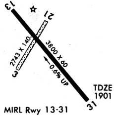
| Runways: | 03/21 13/31 |
| Longest Runway: | 13/31 is 4504 ft (1373 m) long |
| Runways with an Instrument Approach: |
KPHG Airport Runway Details
| Runway 03/21 | 2745 ft x 140 ft (837 m x 43 m) | |
| Runway Length Source: | 3RD PARTY SURVEY as of 08/10/2010 | |
| Surface: | Turf - Excellent condition - No special surface treatment | |
Runway 03 |
Runway 21 |
|
Elevation: |
1892.7 | 1899.7 |
Latitude: |
39-44-04.0589N | 39-44-25.8851N |
Longitude: |
099-19-17.7556W | 099-18-56.8833W |
|
Runway True Alignment: |
036 | 216 |
Glide Path Angle: |
0.0 degrees | 0.0 degrees |
Traffic Pattern: |
Left | Left |
Runway Markings Type: |
Nonstandard (other than numbers only) | Nonstandard (other than numbers only) |
Object at End: |
TREES | |
Object Height: |
36 | |
Distance from End: |
597 | |
Object Centerline Offset: |
84 ft. left of centerline |
| Runway 13/31 | 4504 ft x 60 ft (1373 m x 18 m) | |
| Runway Length Source: | 3RD PARTY SURVEY as of 08/10/2010 | |
| Surface: | Turf - Excellent condition - No special surface treatment | |
| Runway Edge Lights: | Medium Intensity | |
Runway Weight Bearing Capacity (in thousands of pounds) |
||
| Single Wheel Landing Gear: | 12.5 | |
Runway 13 |
Runway 31 |
|
Elevation: |
1906.8 | 1884.5 |
Latitude: |
39-44-22.8899N | 39-43-47.4626N |
Longitude: |
099-19-15.5303W | 099-18-40.6332W |
|
Runway True Alignment: |
143 | 323 |
Glide Path Angle: |
0.0 degrees | 0.0 degrees |
Traffic Pattern: |
Left | Left |
Runway Markings Type: |
Nonprecision Instrument | Nonprecision Instrument |
Runway Markings Condition: |
Good | Good |
Object at End: |
ROAD | PLINE |
Object Height: |
15 | 37 |
Object Marked/Lighted?: |
Marked | |
Distance from End: |
533 | 710 |
Object Centerline Offset: |
84 ft. left of centerline | |
Visual Glide Slope Indicators: |
2-Light PAPI On Left Side Of Runway | 2-Light PAPI On Left Side Of Runway |
REIL: |
Yes | Yes |
Services
Airframe Repair: |
Major |
Powerplant Repair: |
Major |
Bottled Oxygen: |
None |
Bulk Oxygen: |
None |
Fuel Available: |
100LL, Jet A |
Landing Fees: |
No |
Parking: |
Hangars and tiedowns available |
Maps & Diagrams
KPHG Sectional
Flight Planning
at skyvector.com
at skyvector.com