Location
Latitude: |
61-08-03.1990N (61.134222) |
Longitude: |
146-14-41.1650W (-146.244768) |
Elevation: |
128.0 feet MSL (39 m MSL) |
Magnetic Variation: |
16 E (as of May 2024 from WMM2020 model) |
Time Zone: |
UTC -9.0 (Standard Time) UTC -8.0 (Daylight Savings Time) |
From City: |
03 N.M. E of Valdez, Alaska |
Found On: |
Anchorage Chart |
FAA Region: |
AAL |
Contacts
Manager: |
Publicly owned: |
| TODD BISCHOFF DIMOND BOX 507 VALDEZ, AK 99686 907-835-5658 |
ALASKA DOT&PF NORTHERN REGION 2301 PEGER ROAD FAIRBANKS, AK 99709 907-451-5217 |
Operations
Airport Status: |
Operational |
Facility Use: |
Public |
Type: |
Airport |
Activation Date: |
10/1952 |
Control tower: |
No |
Attendance (Months/Days/Hours): |
Months/Days/Hours JAN-DEC/MON - FRI/0600-1830 |
Boundary ARTCC: |
ZAN (Anchorage) |
Responsible ARTCC: |
ZAN (Anchorage) |
Lighting Schedule: |
SEE RMK |
Segmented Circle Indicator: |
Yes |
Traffic Pattern Altitude (MSL): |
1128 feet (344 m) |
NOTAMs Facility: |
VDZ |
NOTAM-D Service: |
Yes |
International Airport of Entry: |
No |
Customs Landing Rights: |
Yes |
Military Landing Rights: |
Yes |
Civil/Military Joint Use: |
No |
Aircraft Rescue and Firefighting: |
Class I ARFF Index: A Air Carrier Service: Scheduled Certification Date: 04/2005 |
Based Aircraft
| Single Engine: | 25 |
| Multi Engine: | 1 |
| GA Helicopters: | 7 |
| Ultralights: | 2 |
Annual Operations (as of 12/31/2021)
| Total Operations: | 10300 | |
| Commercial: | 500 | 4.9% |
| Air Taxi: | 3800 | 36.9% |
| GA Local: | 2500 | 24.3% |
| GA Itinerant: | 3000 | 29.1% |
| Military Aircraft: | 500 | 4.9% |
Communications
| CTAF: | 122.900 |
| AWOS-3P: | 118.8 (907-835-5578) |
- APCH/DEP SVC PRVDD BY ANCHORAGE ARTCC ON FREQS 269.4 (MIDDLETON ISLAND RCAG) AND 119.3 (JOHNSTONE POINT RCAG).
- COMMUNICATIONS PRVDD BY JUNEAU FSS ON FREQ 122.2 (VALDEZ RCO).
Fixed Based Operators (FBOs) & Fuel
(Click on a business for detail)
Please help us keep this information up to date. This is a FREE SERVICE just like everything else on Airport Guide! If you see that a business needs to be added, modified, or deleted please fill out our Update Form.
To add, modify, or delete a business click here.
Please help us keep this information up to date. This is a FREE SERVICE just like everything else on Airport Guide! If you see that a business needs to be added, modified, or deleted please fill out our Update Form.
Area Code: 907 |
| Business Name | Frequency | Phone | Fuel Grade |
|---|
Flight Service Stations
| Primary | Alternate | |
| FSS on Field: | N | |
| FSS Name (ID): | Juneau(JNU) | |
| Frequency: | ||
| Toll Free Phone: | 1-866-297-2236 |
Instrument Procedures / Charts
FAA Terminal Procedures valid from 0901Z 03/21/24 to 0901Z 04/18/24.
There are various types of charts available for an airport. They are listed in the Page Type column. Here is a legend for those types:
APD - Airport Diagram
DP - Departure Procedure Charts
HOT - Hot Spots
IAP - Instrument Approach Procedure Charts
MIN - Minimums
STAR - Standard Terminal Arrival Charts
| Page Type | Page Name | Volume | Action Since Last Cycle |
|---|---|---|---|
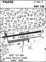
| DP | NAKED SIX | AK-1 | |
| IAP | LDA-H | AK-1 | |
| MIN | ALTERNATE MINIMUMS | AK-1 | |
| MIN | TAKEOFF MINIMUMS | AK-1 | |
| ODP | JMAAL THREE (OBSTACLE) | AK-1 |
Terminal Procedures are only available for airports in several countries with more being added all the time. If you are looking for a specific country's charts, please send an email to support(at)airportguide.com stating the country name. This will be used to prioritize the implementation.
Navigation Aids (Navaids) near VDZ
| Dist (NM) | ID | Morse Code | Name | Type | Freq | True Hdg | Mag Hdg |
|---|---|---|---|---|---|---|---|
| 3.2 | MNL | _ _ _ . . _ . . | Mineral Creek | NDB | 524 | 259 | 243 |
| 40.5 | ALJ | . _ . _ . . . _ _ _ | Orca Bay | NDB | 233 | 194 | 178 |
| 40.5 | JOH | . _ _ _ _ _ _ . . . . | Johnstone Point | VOR-DME | 116.70 | 194 | 178 |
| 44.3 | GCR | _ _ . _ . _ . . _ . | Glacier River | NDB | 404 | 149 | 133 |
| 65.3 | GKN | _ _ . _ . _ _ . | Gulkana | VOR-DME | 115.60 | 20 | 4 |
| 67.4 | GLA | _ _ . . _ . . . _ | Glennallen | NDB | 248 | 18 | 2 |
Nearby Airports with Fuel
| Dist (NM) | Name (Airport IDs) | True Hdg | Mag Hdg | Fuel Grade |
|---|---|---|---|---|
| 38.5 | Cordova Municipal Airport (CKU CKU) |
156 | 140 | 100LL |
| 86.3 | Warren 'Bud' Woods Palmer Municipal Airport (PAQ PAAQ PAQ) |
289 | 274 | 100LL, Jet A-1 |
| 94.9 | Wasilla Lake Seaplane Base (5L6) |
287 | 272 | 100LL |
| 95.6 | Birchwood Airport (PABV BCV) |
281 | 266 | 100LL |
| 98.3 | Wasilla Airport (WWA PAWS IYS) |
286 | 271 | 100LL, Jet A |
Notices to Airmen (NOTAMS)
Remarks
| A110-11 | 1675 X 200 FT SW PTN OF RAMP NOT MNTND NOV 1 - APR 15. |
| A110-12 | MAINT HRS MON-FRI 0600-1830; SAT & SUN 0800-1830. |
| A110-4 | ALERT: DURG STRONG N WIND; MIDFIELD & E END RWY WIND MAY BE MUCH HYR THAN AWOS INDCD. |
| A110-5 | ALERT: SEE SPL NOTICE - PORT VALDEZ AREA & GENOTS - THOMPSON PASS AVALANCHE CTL. |
| A110-6 | POTATO POINT WX CAMERA AVBL ON INTERNET AT HTTPS://WEATHERCAMS.FAA.GOV |
| A110-8 | ARPT SAND LRGR THAN FAA RCMDD/SEE AC150/5200-30. |
| A110-9 | COLD TEMPERATURE AIRPORT. ALTITUDE CORRECTION REQUIRED AT OR BELOW -11C. |
| A26 | CLSD TO ACR OPS MORE THAN 30 PAX SEATS EXC 24 HR PPR IN WRITING - AMGR PO BOX 507 VALDEZ AK 99686; FAX 907-835-5849. |
| A70-FUEL-A | PPR - 907-834-6933. |
| A81-APT | ACTVT MALSR RWY 06; REIL RWY 24; PAPI RWY 06; HIRL RWY 06/24 - CTAF. |
Runways
Runway Summary
| Runways: | 06/24 |
| Longest Runway: | 06/24 is 6500 ft (1981 m) long |
| Runways with an Instrument Approach: | 06 |
VDZ Airport Runway Details
| Runway 06/24 | 6500 ft x 150 ft (1981 m x 46 m) | |
| Runway Length Source: | FAA as of 12/12/2005 | |
| Surface: | Asphalt - Good condition - Saw-cut or plastic grooved | |
| Runway Pavement Class: | 54 /F/B/X/T | |
| Runway Edge Lights: | High Intensity | |
Runway Weight Bearing Capacity (in thousands of pounds) |
||
| Single Wheel Landing Gear: | 75.0 | |
| Dual Wheel Landing Gear: | 200.0 | |
| Dual Tandem Wheel Landing Gear: | 300.0 | |
Runway 06 |
Runway 24 |
|
Elevation: |
57.4 | 128.0 |
Latitude: |
61-07-58.3433N | 61-08-08.0457N |
Longitude: |
146-15-46.5853W | 146-13-35.7391W |
|
Runway True Alignment: |
081 | 261 |
ILS Type: |
LDA/DME | |
Glide Path Angle: |
3.0 degrees | 0.0 degrees |
Traffic Pattern: |
Right | Left |
Runway Markings Type: |
Precision Instrument | Nonprecision Instrument |
Runway Markings Condition: |
Fair | Fair |
Object at End: |
TREES | TREES |
Object Height: |
55 | 77 |
Distance from End: |
2100 | 1580 |
Object Centerline Offset: |
0 ft. left and right of centerline | 0 ft. left and right of centerline |
Visual Glide Slope Indicators: |
4-Light PAPI On Left Side Of Runway | |
Approach Light System: |
1,400 Foot Medium Intensity Approach Lighting System With Runway Alignment Indicator Lights | |
REIL: |
No | Yes |
Threshold Crossing Height: |
29 | |
Declared Distances |
||
Take Off Run Avbl. (TORA): |
6500 | 6500 |
Take Off Distance Avbl. (TODA): |
6500 | 6500 |
Actual Stop Dist. Avbl. (ASDA): |
6500 | 6500 |
Landing Dist. Avbl. (LDA): |
6500 | 6500 |
Services
Airframe Repair: |
Major |
Powerplant Repair: |
Major |
Fuel Available: |
100LL, Jet A |
Maps & Diagrams
VDZ Sectional
Flight Planning
at skyvector.com
at skyvector.com