
Location
Latitude: |
34-51-30.2344N (34.858398) |
Longitude: |
136-48-17.9736E (136.804993) |
Elevation: |
15 feet MSL (5 m MSL) |
Magnetic Variation: |
8 W (as of April 2024 from WMM2020 model) |
Time Zone: |
UTC +9.0 (Standard Time) UTC +9.0 (Daylight Savings Time) |
Contacts
Manager: |
: |
Operations
Airport Status: |
Operational |
Facility Use: |
Public |
Type: |
Airport |
Traffic Pattern Altitude (MSL): |
1015 feet (309 m) |
Based Aircraft
Annual Operations (as of )
Communications
| TWR: | 118.85 |
| CLD: | 121.85 |
| GND: | 121.8 |
| APP: | 121.05 |
| DEP: | 120 |
| ATIS: | 121.075 |
| RDR: | 125.5 |
| TCA: | 119.25 |
Fixed Based Operators (FBOs) & Fuel
(Click on a business for detail)
Please help us keep this information up to date. This is a FREE SERVICE just like everything else on Airport Guide! If you see that a business needs to be added, modified, or deleted please fill out our Update Form.
To add, modify, or delete a business click here.
Please help us keep this information up to date. This is a FREE SERVICE just like everything else on Airport Guide! If you see that a business needs to be added, modified, or deleted please fill out our Update Form.
| Business Name | Frequency | Phone | Fuel Grade |
|---|
Flight Service Stations
| Primary | Alternate | |
| FSS on Field: | ||
| FSS Name (ID): | ||
| Frequency: | ||
| Toll Free Phone: |
Instrument Procedures / Charts
Terminal Procedures are only available for airports in several countries with more being added all the time. If you are looking for a specific country's charts, please send an email to support(at)airportguide.com stating the country name. This will be used to prioritize the implementation.
Navigation Aids (Navaids) near NGO
| Dist (NM) | ID | Morse Code | Name | Type | Freq | True Hdg | Mag Hdg |
|---|---|---|---|---|---|---|---|
| 0.1 | CBE | Chubu | VOR-DME | 117.80 | 256 | 264 | |
| 8.7 | XM | Kowa | NDB | 325 | 136 | 144 | |
| 11.9 | XMC | Kowa | VORTAC | 113.50 | 140 | 148 | |
| 19.5 | NG | Aichi | NDB | 397 | 28 | 36 | |
| 20.5 | AK | Akeno | NDB | 380 | 195 | 203 | |
| 20.8 | AKT | Akeno | TACAN | 112.05 | 197 | 205 | |
| 24.7 | KC | Nagoya | NDB | 360 | 12 | 20 | |
| 25.0 | KCC | Nagoya | VORTAC | 114.20 | 12 | 20 | |
| 32.1 | GFT | Gifu | TACAN | 112.25 | 4 | 12 | |
| 43.7 | LHE | Hamamatsu | VOR-DME | 110.00 | 98 | 106 | |
| 45.1 | LHT | Hamamatsu | TACAN | 114.70 | 98 | 106 | |
| 47.4 | CU | Otsu | NDB | 368 | 284 | 292 | |
| 49.1 | CUE | Otsu | VOR-DME | 117.10 | 281 | 289 | |
| 58.0 | SIE | Shigi | VOR-DME | 111.60 | 256 | 264 | |
| 61.7 | YOE | Yao | VOR-DME | 114.60 | 255 | 263 | |
| 62.7 | RK | Osaka | NDB | 340 | 260 | 268 | |
| 66.8 | OWE | Osaka | VOR-DME | 113.90 | 266 | 274 | |
| 69.1 | OW | Itami | NDB | 211 | 267 | 275 | |
| 70.5 | SKE | Shinoda | VOR-DME | 112.30 | 252 | 260 | |
| 70.7 | SK | Shinoda | NDB | 219 | 252 | 260 |
Nearby Airports with Fuel
| Dist (NM) | Name (Airport IDs) | True Hdg | Mag Hdg | Fuel Grade |
|---|---|---|---|---|
| 79.1 | Kobe Airport (UKB RJBE) |
260 | 268 | Please confirm |
Notices to Airmen (NOTAMS)
Remarks
No remarks for this landing facility
Runways
Runway Summary
| Runways: | 18/36 |
| Longest Runway: | 18/36 is 11483 ft (3500 m) long |
| Runways with an Instrument Approach: |
NGO Airport Runway Details
| Runway 18/36 | 11483 ft x 197 ft (3500 m x 60 m) | |
| Runway Edge Lights: | Yes Intensity | |
Runway 18 |
Runway 36 |
|
Elevation: |
15 | 15 |
Latitude: |
34.87390136718 | 34.84289932250 |
Longitude: |
136.80200195312 | 136.80900573730 |
|
Runway True Alignment: |
168.8 | 348.8 |
Glide Path Angle: |
0.0 degrees | 0.0 degrees |
REIL: |
Yes | Yes |
Threshold Elevation: |
15 | 15 |
Services
Fuel Available: |
Please confirm |
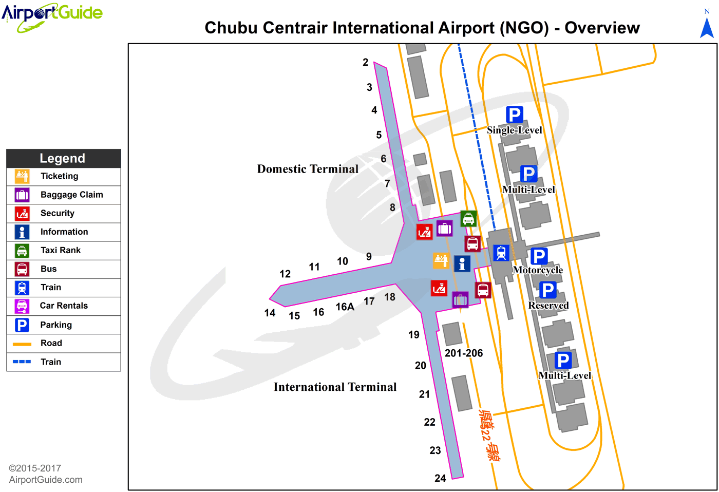
Maps & Diagrams
NGO Sectional
Flight Planning
at skyvector.com
at skyvector.com
