Location
Latitude: |
38-14-00.5000N (38.233472) |
Longitude: |
091-09-51.4000W (-91.164278) |
Elevation: |
933.0 feet MSL (284 m MSL) |
Magnetic Variation: |
1.2 W (as of April 2024 from WMM2020 model) |
Time Zone: |
UTC -6.0 (Standard Time) UTC -5.0 (Daylight Savings Time) |
From City: |
01 N.M. N of Sullivan, Missouri |
Found On: |
Kansas City Chart |
FAA Region: |
ACE |
Contacts
Manager: |
Publicly owned: |
| BILLY PARKER 345 N. CHURCH ST SULLIVAN, MO 63080 (573) 468-4912 |
CITY OF SULLIVAN 210 W. WASHINGTON ST SULLIVAN, MO 63080 573-468-4612 |
Operations
Airport Status: |
Operational |
Facility Use: |
Public |
Type: |
Airport |
Activation Date: |
04/1991 |
Control tower: |
No |
Attendance (Months/Days/Hours): |
Months/Days/Hours ALL/ALL/0700-1600 |
Boundary ARTCC: |
ZKC (Kansas City) |
Responsible ARTCC: |
ZKC (Kansas City) |
Lighting Schedule: |
SEE RMK |
Segmented Circle Indicator: |
Yes |
Traffic Pattern Altitude (MSL): |
1933 feet (589 m) |
NOTAMs Facility: |
STL |
NOTAM-D Service: |
Yes |
Based Aircraft
| Single Engine: | 39 |
| Multi Engine: | 1 |
| GA Helicopters: | 1 |
Annual Operations (as of 12/31/2021)
| Total Operations: | 20272 | |
| Air Taxi: | 72 | 0.4% |
| GA Local: | 16170 | 79.8% |
| GA Itinerant: | 3950 | 19.5% |
| Military Aircraft: | 80 | 0.4% |
Communications
| CTAF: | 122.700 |
| Unicom: | 122.700 |
| AWOS-3PT: | 119.375 (573-860-2596) |
- APCH/DEP SVC PRVDD BY KANSAS CITY ARTCC ON FREQS 128.35/284.675 (MAPLES RCAG).
Fixed Based Operators (FBOs) & Fuel
(Click on a business for detail)
Please help us keep this information up to date. This is a FREE SERVICE just like everything else on Airport Guide! If you see that a business needs to be added, modified, or deleted please fill out our Update Form.
To add, modify, or delete a business click here.
Please help us keep this information up to date. This is a FREE SERVICE just like everything else on Airport Guide! If you see that a business needs to be added, modified, or deleted please fill out our Update Form.
Area Code: 573 |
| Business Name | Frequency | Phone | Fuel Grade |
|---|---|---|---|
| Sullivan Aviation
Update FBO info |
Unicom 122.7 | 468-2631 | 100LL, Jet A |
Flight Service Stations
| Primary | Alternate | |
| FSS on Field: | N | |
| FSS Name (ID): | Saint Louis(STL) | |
| Frequency: | ||
| Toll Free Phone: | 1-800-WX-BRIEF |
Instrument Procedures / Charts
FAA Terminal Procedures valid from 0901Z 03/21/24 to 0901Z 04/18/24.
There are various types of charts available for an airport. They are listed in the Page Type column. Here is a legend for those types:
APD - Airport Diagram
DP - Departure Procedure Charts
HOT - Hot Spots
IAP - Instrument Approach Procedure Charts
MIN - Minimums
STAR - Standard Terminal Arrival Charts
| Page Type | Page Name | Volume | Action Since Last Cycle |
|---|---|---|---|
| IAP | RNAV (GPS) RWY 06 | NC-3 | |
| IAP | RNAV (GPS) RWY 24 | NC-3 | |
| MIN | TAKEOFF MINIMUMS | NC-3 |
Terminal Procedures are only available for airports in several countries with more being added all the time. If you are looking for a specific country's charts, please send an email to support(at)airportguide.com stating the country name. This will be used to prioritize the implementation.
Navigation Aids (Navaids) near KUUV
| Dist (NM) | ID | Morse Code | Name | Type | Freq | True Hdg | Mag Hdg |
|---|---|---|---|---|---|---|---|
| 0.1 | UUV | . . _ . . _ . . . _ | Sullivan | NDB | 356 | 3 | 4 |
| 26.0 | VIH | . . . _ . . . . . . | Vichy | VOR-DME | 117.70 | 259 | 260 |
| 29.1 | FTZ | . . _ . _ _ _ . . | Foristell | VORTAC | 110.80 | 18 | 19 |
| 30.7 | SU | . . . . . _ | Snoop | NDB | 326 | 37 | 38 |
| 35.3 | SUS | . . . . . _ . . . | Spirit Of St Louis | VOT | 112.20 | 42 | 43 |
| 36.7 | FES | . . _ . . . . . | Festus | NDB | 269 | 93 | 95 |
| 39.4 | FZ | . . _ . _ _ . . | Eaves | NDB | 227 | 47 | 48 |
| 44.8 | PRI | . _ _ . . _ . . . | Perrine | NDB | 367 | 128 | 129 |
| 46.7 | JE | . _ _ _ . | Algoa | NDB | 397 | 294 | 295 |
| 47.0 | LM | . _ . . _ _ | Oblio | NDB | 338 | 43 | 44 |
| 48.4 | STL | . . . _ . _ . . | St Louis Lambert | VOT | 111.00 | 50 | 52 |
| 48.6 | MAP | _ _ . _ . _ _ . | Maples | TACAN | 113.40 | 217 | 218 |
| 48.9 | CSX | _ . _ . . . . _ . . _ | Cardinal | DME | 116.45 | 50 | 52 |
| 49.4 | STL | . . . _ . _ . . | St Louis | VORTAC | 117.40 | 40 | 41 |
| 52.0 | JEF | . _ _ _ . . . _ . | Jefferson City | VOT | 112.00 | 295 | 296 |
| 53.2 | ST | . . . _ | Zumay | NDB | 404 | 51 | 53 |
| 54.7 | TBN | _ _ . . . _ . | Forney | VOR | 110.00 | 237 | 238 |
| 54.7 | CP | _ . _ . . _ _ . | Acore | NDB | 350 | 71 | 73 |
| 54.9 | BHN | _ . . . . . . . _ . | Buckhorn | NDB | 391 | 234 | 235 |
| 55.4 | FAM | . . _ . . _ _ _ | Farmington | VORTAC | 115.70 | 127 | 129 |
Nearby Airports with Fuel
Notices to Airmen (NOTAMS)
Remarks
| A110-2 | DEER, COYOTES, WATERFOWL ON & INVOF ARPT. |
| A110-3 | FOR CD CTC KANSAS CITY ARTCC AT 913-254-8508. |
| A17 | AFT HRS CALL 573-468-8001 (POLICE DEPT.) |
| A30-06/24 | RESTRICTED TO ACFT 12,500 LBS MAX GWT OR LESS; PPR FOR ACFT EXCEEDING 12,500 LBS CALL AMGR. |
| A81-APT | DUSK-DAWN. MIRL RY 06/24 PRESET ON LOW INTST; TO INCR INTST ACTVT - CTAF. PAPI ON 24 HRS. |
| E111 | PRVDD EXISTING SULLIVAN MEMORIAL ARPT IS CLSD UPON ACTIVATION OF SULLIVAN REGIONAL ARPT. |
Runways
Runway Summary
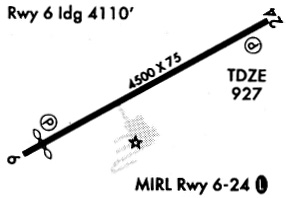
| Runways: | 06/24 |
| Longest Runway: | 06/24 is 4500 ft (1372 m) long |
| Runways with an Instrument Approach: |
KUUV Airport Runway Details
| Runway 06/24 | 4500 ft x 75 ft (1372 m x 23 m) | |
| Runway Length Source: | 3RD PARTY SURVEY as of 03/19/1999 | |
| Surface: | Concrete - Good condition - No special surface treatment | |
| Runway Edge Lights: | Medium Intensity | |
Runway Weight Bearing Capacity (in thousands of pounds) |
||
| Single Wheel Landing Gear: | 12.5 | |
Runway 06 |
Runway 24 |
|
Elevation: |
933.0 | 924.0 |
Latitude: |
38-13-49.4856N | 38-14-11.5737N |
Longitude: |
091-10-15.9007W | 091-09-26.9504W |
|
Runway True Alignment: |
060 | 240 |
Glide Path Angle: |
4.0 degrees | 3.0 degrees |
Traffic Pattern: |
Right | |
Runway Markings Type: |
Nonprecision Instrument | Nonprecision Instrument |
Runway Markings Condition: |
Good | Good |
Object at End: |
TREES | |
Object Height: |
44 | |
Distance from End: |
810 | |
Object Centerline Offset: |
110 ft. right of centerline | |
Visual Glide Slope Indicators: |
2-Light PAPI On Left Side Of Runway | 2-Light PAPI On Left Side Of Runway |
Threshold Crossing Height: |
57 | 27 |
Services
Bottled Oxygen: |
None |
Bulk Oxygen: |
None |
Fuel Available: |
100LL |
Landing Fees: |
No |
Parking: |
Tiedowns available |
Maps & Diagrams
KUUV Sectional
Flight Planning
at skyvector.com
at skyvector.com