Location
Latitude: |
37-00-02.8160N (37.000782) |
Longitude: |
101-52-48.1000W (-101.880028) |
Elevation: |
3621.9 feet MSL (1104 m MSL) |
Magnetic Variation: |
5.8 E (as of April 2024 from WMM2020 model) |
Time Zone: |
UTC -6.0 (Standard Time) UTC -5.0 (Daylight Savings Time) |
From City: |
01 N.M. E of Elkhart, Kansas |
Found On: |
Wichita Chart |
FAA Region: |
ACE |
Contacts
Manager: |
Publicly owned: |
| DENNIS TEVEBAUGH PO BOX 392 ELKHART, KS 67950 (620) 360-6100 |
MORTON COUNTY P.O. BOX 1116 ELKHART, KS 67950 620-697-2157 |
Operations
Airport Status: |
Operational |
Facility Use: |
Public |
Type: |
Airport |
Activation Date: |
01/1942 |
Control tower: |
No |
Attendance (Months/Days/Hours): |
Months/Days/Hours Unattended |
Boundary ARTCC: |
ZKC (Kansas City) |
Responsible ARTCC: |
ZKC (Kansas City) |
Lighting Schedule: |
SEE RMK |
Segmented Circle Indicator: |
Yes |
Traffic Pattern Altitude (MSL): |
4622 feet (1409 m) |
NOTAMs Facility: |
ICT |
NOTAM-D Service: |
Yes |
International Airport of Entry: |
No |
Customs Landing Rights: |
No |
Military Landing Rights: |
Yes |
Civil/Military Joint Use: |
No |
Based Aircraft
| Single Engine: | 8 |
| Multi Engine: | 3 |
Annual Operations (as of 09/26/2022)
| Total Operations: | 6000 | |
| GA Local: | 3400 | 56.7% |
| GA Itinerant: | 2600 | 43.3% |
Communications
| CTAF: | 122.800 |
| Unicom: | 122.800 |
| AWOS-3P: | 118.025 (620-697-4973) |
- APCH/DEP CTL SVC PRVDD BY KANSAS CITY ARTCC (ZKC) ON FREQS 134.0/257.625 (LIBERAL RCAG).
Fixed Based Operators (FBOs) & Fuel
(Click on a business for detail)
Please help us keep this information up to date. This is a FREE SERVICE just like everything else on Airport Guide! If you see that a business needs to be added, modified, or deleted please fill out our Update Form.
To add, modify, or delete a business click here.
Please help us keep this information up to date. This is a FREE SERVICE just like everything else on Airport Guide! If you see that a business needs to be added, modified, or deleted please fill out our Update Form.
Area Code: 620 |
| Business Name | Frequency | Phone | Fuel Grade |
|---|
Flight Service Stations
| Primary | Alternate | |
| FSS on Field: | N | |
| FSS Name (ID): | Wichita(ICT) | |
| Frequency: | ||
| Toll Free Phone: | 1-800-WX-BRIEF |
Instrument Procedures / Charts
FAA Terminal Procedures valid from 0901Z 03/21/24 to 0901Z 04/18/24.
There are various types of charts available for an airport. They are listed in the Page Type column. Here is a legend for those types:
APD - Airport Diagram
DP - Departure Procedure Charts
HOT - Hot Spots
IAP - Instrument Approach Procedure Charts
MIN - Minimums
STAR - Standard Terminal Arrival Charts
| Page Type | Page Name | Volume | Action Since Last Cycle |
|---|---|---|---|
| IAP | RNAV (GPS) RWY 04 | NC-2 | |
| IAP | RNAV (GPS) RWY 17 | NC-2 | |
| IAP | RNAV (GPS) RWY 22 | NC-2 | |
| IAP | RNAV (GPS) RWY 35 | NC-2 | |
| MIN | ALTERNATE MINIMUMS | NC-2 | |
| MIN | TAKEOFF MINIMUMS | NC-2 |
Terminal Procedures are only available for airports in several countries with more being added all the time. If you are looking for a specific country's charts, please send an email to support(at)airportguide.com stating the country name. This will be used to prioritize the implementation.
Navigation Aids (Navaids) near KEHA
| Dist (NM) | ID | Morse Code | Name | Type | Freq | True Hdg | Mag Hdg |
|---|---|---|---|---|---|---|---|
| 0.2 | EHA | . . . . . . _ | Elkhart | NDB | 377 | 275 | 269 |
| 25.3 | GUY | _ _ . . . _ _ . _ _ | Guymon | NDB | 275 | 134 | 128 |
| 26.1 | HQG | . . . . _ _ . _ _ _ . | Hugoton | NDB | 365 | 67 | 61 |
| 38.7 | JHN | . _ _ _ . . . . _ . | Bear Creek | NDB | 341 | 10 | 4 |
| 43.3 | ULS | . . _ . _ . . . . . | Ulysses | NDB | 395 | 34 | 28 |
| 43.6 | LBL | . _ . . _ . . . . _ . . | Liberal | TACAN | 112.30 | 86 | 80 |
| 44.3 | LB | . _ . . _ . . . | Panck | NDB | 383 | 92 | 87 |
| 63.3 | DHT | _ . . . . . . _ | Dalhart | VORTAC | 112.00 | 210 | 204 |
| 64.9 | PYX | . _ _ . _ . _ _ _ . . _ | Perryton | NDB | 266 | 122 | 117 |
| 69.6 | CAO | _ . _ . . _ _ _ _ | Clayton | NDB | 332 | 241 | 235 |
| 74.2 | GC | _ _ . _ . _ . | Pieve | NDB | 347 | 47 | 42 |
| 75.5 | BGD | _ . . . _ _ . _ . . | Borger | TACAN | 108.60 | 161 | 155 |
| 77.9 | GCK | _ _ . _ . _ . _ . _ | Garden City | VORTAC | 113.30 | 44 | 39 |
| 81.4 | LAA | . _ . . . _ . _ | Lamar | VOR-DME | 116.90 | 332 | 326 |
| 83.7 | TBE | _ _ . . . . | Tobe | VOR-DME | 114.05 | 281 | 275 |
| 93.7 | PPA | . _ _ . . _ _ . . _ | Pampa | NDB | 368 | 152 | 147 |
Nearby Airports with Fuel
Notices to Airmen (NOTAMS)
Remarks
| A110-2 | PUBLIC PHONE (620) 697-9803. |
| A110-3 | FOR CD CTC KANSAS CITY ARTCC AT 913-254-8508. |
| A16 | CELL PHONE # 620-360-3600. |
| A52-22 | PIVOT IRRIGATION TWR (MOVING WHEN IN OPN). |
| A70-FUEL-10 | 0LL FOR FUEL CALL (620) 697-2803. |
| A81-APT | ACTVT PAPI RWY 04, 17, 22 & 35; MIRL RWY 04/22 & 17/35 - CTAF. |
Runways
Runway Summary
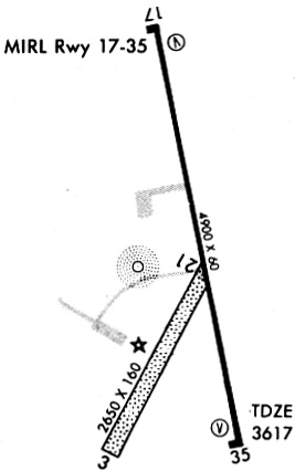
| Runways: | 04/22 17/35 |
| Longest Runway: | 17/35 is 4907 ft (1496 m) long |
| Runways with an Instrument Approach: |
KEHA Airport Runway Details
| Runway 04/22 | 4900 ft x 60 ft (1494 m x 18 m) | |
| Runway Length Source: | 3RD PARTY SURVEY as of 10/15/2019 | |
| Surface: | Asphalt - Fair condition - No special surface treatment | |
| Runway Pavement Class: | 5 /F/C/Y/U | |
| Runway Edge Lights: | Medium Intensity | |
Runway 04 |
Runway 22 |
|
Elevation: |
3621.8 | 3594.1 |
Latitude: |
36-59-42.7705N | 37-00-14.9107N |
Longitude: |
101-53-03.0720W | 101-52-17.8891W |
|
Runway True Alignment: |
048 | 228 |
Glide Path Angle: |
3.0 degrees | 3.0 degrees |
Traffic Pattern: |
Right | |
Runway Markings Type: |
Nonprecision Instrument | Nonprecision Instrument |
Runway Markings Condition: |
Good | Good |
Object at End: |
ROAD | TOWER |
Object Height: |
15 | 21 |
Distance from End: |
546 | 279 |
Object Centerline Offset: |
0 ft. left and right of centerline | 0 ft. left and right of centerline |
Visual Glide Slope Indicators: |
4-Light PAPI On Left Side Of Runway | 4-Light PAPI On Left Side Of Runway |
Threshold Crossing Height: |
38 | 39 |
| Runway 17/35 | 4907 ft x 75 ft (1496 m x 23 m) | |
| Runway Length Source: | 3RD PARTY SURVEY as of 10/15/2019 | |
| Surface: | Asphalt - Fair condition - No special surface treatment | |
| Runway Pavement Class: | 11 /R/C/X/U | |
| Runway Edge Lights: | Medium Intensity | |
Runway Weight Bearing Capacity (in thousands of pounds) |
||
| Single Wheel Landing Gear: | 30.0 | |
| Dual Wheel Landing Gear: | 30.0 | |
Runway 17 |
Runway 35 |
|
Elevation: |
3607.6 | 3617.6 |
Latitude: |
37-00-31.0388N | 36-59-42.5306N |
Longitude: |
101-52-56.0508W | 101-52-55.3155W |
|
Runway True Alignment: |
179 | 359 |
Glide Path Angle: |
3.0 degrees | 3.0 degrees |
Traffic Pattern: |
Left | Right |
Runway Markings Type: |
Nonprecision Instrument | Nonprecision Instrument |
Runway Markings Condition: |
Good | Good |
Object at End: |
POLE | ROAD |
Object Height: |
18 | 15 |
Distance from End: |
917 | 506 |
Object Centerline Offset: |
0 ft. left and right of centerline | 0 ft. left and right of centerline |
Visual Glide Slope Indicators: |
4-Light PAPI On Left Side Of Runway | 4-Light PAPI On Left Side Of Runway |
Threshold Crossing Height: |
40 | 44 |
Services
Bottled Oxygen: |
None |
Fuel Available: |
100LL, Jet A |
Landing Fees: |
No |
Parking: |
Hangars and tiedowns available |
Other Services: |
Engine overhaul |
Maps & Diagrams
KEHA Sectional
Flight Planning
at skyvector.com
at skyvector.com