Location
Latitude: |
43-22-09.6700N (43.369353) |
Longitude: |
095-45-34.7000W (-95.759639) |
Elevation: |
1537.7 feet MSL (469 m MSL) |
Magnetic Variation: |
1.9 E (as of April 2024 from WMM2020 model) |
Time Zone: |
UTC -6.0 (Standard Time) UTC -5.0 (Daylight Savings Time) |
From City: |
02 N.M. S of Sibley, Iowa |
Found On: |
Omaha Chart |
FAA Region: |
ACE |
Contacts
Manager: |
Publicly owned: |
| ROBERT O'LEARY 1928 OLIVE AVENUE SIBLEY, IA 51249 712-754-3467 |
CITY OF SIBLEY CITY HALL, 808 3RD AVE SIBLEY, IA 51249 712-754-2541 |
Operations
Airport Status: |
Operational |
Facility Use: |
Public |
Type: |
Airport |
Activation Date: |
05/1947 |
Control tower: |
No |
Attendance (Months/Days/Hours): |
Months/Days/Hours ALL/MON - FRI/0600-1800 |
Boundary ARTCC: |
ZMP (Minneapolis) |
Responsible ARTCC: |
ZMP (Minneapolis) |
Lighting Schedule: |
SEE RMK |
Segmented Circle Indicator: |
No |
Traffic Pattern Altitude (MSL): |
2538 feet (774 m) |
NOTAMs Facility: |
FOD |
NOTAM-D Service: |
Yes |
International Airport of Entry: |
No |
Customs Landing Rights: |
No |
Military Landing Rights: |
Yes |
Civil/Military Joint Use: |
No |
Based Aircraft
| Single Engine: | 11 |
Annual Operations (as of 10/15/2021)
| Total Operations: | 2750 | |
| GA Local: | 1188 | 43.2% |
| GA Itinerant: | 1562 | 56.8% |
Communications
| CTAF: | 122.800 |
| Unicom: | 122.800 |
- APCH/DEP SVC PRVDD BY MINNEAPOLIS ARTCC ON FREQS 132.050/317.4 (SIOUX FALLS RCAG).
Fixed Based Operators (FBOs) & Fuel
(Click on a business for detail)
Please help us keep this information up to date. This is a FREE SERVICE just like everything else on Airport Guide! If you see that a business needs to be added, modified, or deleted please fill out our Update Form.
To add, modify, or delete a business click here.
Please help us keep this information up to date. This is a FREE SERVICE just like everything else on Airport Guide! If you see that a business needs to be added, modified, or deleted please fill out our Update Form.
Area Code: 712 |
| Business Name | Frequency | Phone | Fuel Grade |
|---|---|---|---|
| O'Leary Aviation, Inc.
Update FBO info |
Unicom 122.8 | 754-3467 | 100LL |
Flight Service Stations
| Primary | Alternate | |
| FSS on Field: | N | |
| FSS Name (ID): | Fort Dodge(FOD) | |
| Frequency: | ||
| Toll Free Phone: | 1-800-WX-BRIEF |
Instrument Procedures / Charts
FAA Terminal Procedures valid from 0901Z 03/21/24 to 0901Z 04/18/24.
There are various types of charts available for an airport. They are listed in the Page Type column. Here is a legend for those types:
APD - Airport Diagram
DP - Departure Procedure Charts
HOT - Hot Spots
IAP - Instrument Approach Procedure Charts
MIN - Minimums
STAR - Standard Terminal Arrival Charts
| Page Type | Page Name | Volume | Action Since Last Cycle |
|---|---|---|---|
| IAP | RNAV (GPS)-A | NC-3 | |
| MIN | TAKEOFF MINIMUMS | NC-3 |
Terminal Procedures are only available for airports in several countries with more being added all the time. If you are looking for a specific country's charts, please send an email to support(at)airportguide.com stating the country name. This will be used to prioritize the implementation.
Navigation Aids (Navaids) near KISB
| Dist (NM) | ID | Morse Code | Name | Type | Freq | True Hdg | Mag Hdg |
|---|---|---|---|---|---|---|---|
| 0.3 | ISB | . . . . . _ . . . | Sibley | NDB | 269 | 104 | 102 |
| 9.9 | SHL | . . . . . . . . _ . . | Sheldon | NDB | 338 | 199 | 197 |
| 18.4 | OTG | _ _ _ _ _ _ . | Worthington | DME | 110.6 | 24 | 22 |
| 19.7 | OT | _ _ _ _ | Wondd | NDB | 277 | 40 | 38 |
| 20.5 | SP | . . . . _ _ . | Snore | NDB | 394 | 113 | 111 |
| 23.5 | SOY | . . . _ _ _ _ . _ _ | Sioux Center | NDB | 368 | 233 | 231 |
| 26.3 | ORC | _ _ _ . _ . _ . _ . | Orange City | NDB | 521 | 210 | 208 |
| 27.4 | SPW | . . . . _ _ . . _ _ | Spencer | VOR-DME | 115.15 | 116 | 114 |
| 31.0 | LTU | . _ . . _ . . _ | Little Sioux | NDB | 326 | 117 | 115 |
| 37.6 | MJQ | _ _ . _ _ _ _ _ . _ | Jackson | NDB-DME | 353 | 63 | 61 |
| 43.0 | MWM | _ _ . _ _ _ _ | Windom | NDB | 203 | 40 | 38 |
| 44.3 | EST | . . . . _ | Estherville | VOR | 110.40 | 86 | 84 |
| 44.6 | PUF | . _ _ . . . _ . . _ . | Puff | NDB | 345 | 91 | 89 |
| 47.2 | FS | . . _ . . . . | Rokky | NDB | 245 | 279 | 277 |
| 47.5 | FSD | . . _ . . . . _ . . | Sioux Falls | VORTAC | 115.00 | 291 | 289 |
| 48.7 | EGQ | . _ _ . _ _ . _ | Emmetsburg | NDB | 410 | 108 | 106 |
| 51.4 | SLB | . . . . _ . . _ . . . | Storm Lake | NDB | 434 | 153 | 151 |
| 60.5 | FRM | . . _ . . _ . _ _ | Fairmont | DME | 110.2 | 73 | 72 |
| 60.8 | FNX | . . _ . _ . _ . . _ | Fairmont | DME | 114.25 | 74 | 73 |
| 61.4 | POH | . _ _ . _ _ _ . . . . | Pocahontas | NDB | 428 | 127 | 126 |
Nearby Airports with Fuel
Notices to Airmen (NOTAMS)
Remarks
| A110-1 | RY 35 IS CALM WIND RY. |
| A110-2 | FOR CD CTC MINNEAPOLIS ARTCC AT 651-463-5588. |
| A17 | FOR ATTENDANT AFTER HOURS CALL 712-754-3467. |
| A40-17/35 | LIRL-RWY 17/35 HAVE 6 THLD LGTS EACH. |
| A81-APT | ACTVT LIRL RY 17/35 AND PAPI RYS 17 & 35 - CTAF. |
Runways
Runway Summary
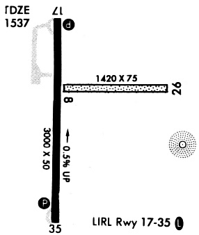
| Runways: | 17/35 |
| Longest Runway: | 17/35 is 3000 ft (914 m) long |
| Runways with an Instrument Approach: |
KISB Airport Runway Details
| Runway 17/35 | 3000 ft x 50 ft (914 m x 15 m) | |
| Runway Length Source: | FAA-EST as of 11/03/2009 | |
| Surface: | Concrete - Fair condition - No special surface treatment | |
| Runway Edge Lights: | Non-standard lighting system Intensity | |
Runway Weight Bearing Capacity (in thousands of pounds) |
||
| Single Wheel Landing Gear: | 28.0 | |
| Dual Wheel Landing Gear: | 48.0 | |
Runway 17 |
Runway 35 |
|
Elevation: |
1535.8 | 1522.8 |
Latitude: |
43-22-24.4900N | 43-21-54.8500N |
Longitude: |
095-45-34.6900W | 095-45-34.7100W |
|
Runway True Alignment: |
180 | 000 |
Glide Path Angle: |
3.0 degrees | 3.0 degrees |
Traffic Pattern: |
Left | Left |
Runway Markings Type: |
Nonprecision Instrument | Nonprecision Instrument |
Runway Markings Condition: |
Fair | Fair |
Object at End: |
ROAD | TREES |
Object Height: |
15 | 77 |
Distance from End: |
515 | 1787 |
Object Centerline Offset: |
206 ft. right of centerline | 51 ft. right of centerline |
Visual Glide Slope Indicators: |
2-Light PAPI On Left Side Of Runway | 2-Light PAPI On Left Side Of Runway |
Threshold Crossing Height: |
31 | 20 |
Services
Airframe Repair: |
Major |
Powerplant Repair: |
Major |
Bottled Oxygen: |
None |
Bulk Oxygen: |
None |
Fuel Available: |
100LL, Jet A |
Landing Fees: |
No |
Parking: |
Hangars and tiedowns available |
Maps & Diagrams
KISB Sectional
Flight Planning
at skyvector.com
at skyvector.com