Location
Latitude: |
38-08-55.9090N (38.148864) |
Longitude: |
089-41-54.6140W (-89.698504) |
Elevation: |
537.6 feet MSL (164 m MSL) |
Magnetic Variation: |
2.3 W (as of April 2024 from WMM2020 model) |
Time Zone: |
UTC -6.0 (Standard Time) UTC -5.0 (Daylight Savings Time) |
From City: |
02 N.M. N of Sparta, Illinois |
Found On: |
St Louis Chart |
FAA Region: |
AGL |
Contacts
Manager: |
Publicly owned: |
| SCOTT MARQUARDT 1800 N. MARKET SPARTA, IL 62286 (618) 443-5321 |
SPARTA COMM ARPT AUTHORITY 1800 N. MARKET SPARTA, IL 62286 618-443-2002 |
Operations
Airport Status: |
Operational |
Facility Use: |
Public |
Type: |
Airport |
Control tower: |
No |
Attendance (Months/Days/Hours): |
Months/Days/Hours ALL/MON-FRI/0800-1700 |
Boundary ARTCC: |
ZKC (Kansas City) |
Responsible ARTCC: |
ZKC (Kansas City) |
Lighting Schedule: |
SEE RMK |
Segmented Circle Indicator: |
Yes |
Traffic Pattern Altitude (MSL): |
1538 feet (469 m) |
NOTAMs Facility: |
SAR |
NOTAM-D Service: |
Yes |
International Airport of Entry: |
No |
Customs Landing Rights: |
No |
Military Landing Rights: |
Yes |
Civil/Military Joint Use: |
No |
Based Aircraft
| Single Engine: | 30 |
| Multi Engine: | 1 |
| GA Helicopters: | 1 |
Annual Operations (as of 06/30/2021)
| Total Operations: | 34000 | |
| Air Taxi: | 6000 | 17.6% |
| GA Local: | 10000 | 29.4% |
| GA Itinerant: | 15500 | 45.6% |
| Military Aircraft: | 2500 | 7.4% |
Communications
| CTAF: | 123.075 |
| Unicom: | 123.075 |
| Approach: | SAINT LOUIS 125.2 125.2 |
| Departure: | SAINT LOUIS 125.2 125.2 |
| AWOS-3PT: | 118.375 (618-443-3296) |
Fixed Based Operators (FBOs) & Fuel
(Click on a business for detail)
Please help us keep this information up to date. This is a FREE SERVICE just like everything else on Airport Guide! If you see that a business needs to be added, modified, or deleted please fill out our Update Form.
To add, modify, or delete a business click here.
Please help us keep this information up to date. This is a FREE SERVICE just like everything else on Airport Guide! If you see that a business needs to be added, modified, or deleted please fill out our Update Form.
Area Code: 618 |
| Business Name | Frequency | Phone | Fuel Grade |
|---|---|---|---|
| Sparta Aero Services, Inc.
Update FBO info |
Unicom 122.8 | 443-2002, 443-5321 | 100LL, Jet A |
Flight Service Stations
| Primary | Alternate | |
| FSS on Field: | N | |
| FSS Name (ID): | Saint Louis(STL) | |
| Frequency: | ||
| Toll Free Phone: | 1-800-WX-BRIEF |
Instrument Procedures / Charts
FAA Terminal Procedures valid from 0901Z 03/21/24 to 0901Z 04/18/24.
There are various types of charts available for an airport. They are listed in the Page Type column. Here is a legend for those types:
APD - Airport Diagram
DP - Departure Procedure Charts
HOT - Hot Spots
IAP - Instrument Approach Procedure Charts
MIN - Minimums
STAR - Standard Terminal Arrival Charts
| Page Type | Page Name | Volume | Action Since Last Cycle |
|---|---|---|---|
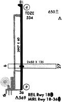
| IAP | RNAV (GPS) RWY 18 | EC-3 | |
| IAP | RNAV (GPS) RWY 36 | EC-3 | |
| MIN | ALTERNATE MINIMUMS | EC-3 | |
| MIN | TAKEOFF MINIMUMS | EC-3 |
Terminal Procedures are only available for airports in several countries with more being added all the time. If you are looking for a specific country's charts, please send an email to support(at)airportguide.com stating the country name. This will be used to prioritize the implementation.
Navigation Aids (Navaids) near SAR
| Dist (NM) | ID | Morse Code | Name | Type | Freq | True Hdg | Mag Hdg |
|---|---|---|---|---|---|---|---|
| 19.2 | BL | _ . . . . _ . . | Belleville | NDB | 362 | 351 | 353 |
| 19.8 | JD | . _ _ _ _ . . | Gooey | NDB | 385 | 354 | 356 |
| 24.9 | SKE | . . . _ . _ . | Scott | TACAN | 112.20 | 343 | 345 |
| 27.2 | MD | _ _ _ . . | Cabbi | NDB | 388 | 127 | 129 |
| 28.0 | CP | _ . _ . . _ _ . | Acore | NDB | 350 | 322 | 324 |
| 30.2 | ENL | . _ . . _ . . | Centralia | VORTAC | 115.00 | 57 | 60 |
| 32.6 | FES | . . _ . . . . . | Festus | NDB | 269 | 275 | 277 |
| 36.9 | TOY | _ _ _ _ _ . _ _ | Troy | VORTAC | 116.00 | 343 | 345 |
| 38.2 | FAM | . . _ . . _ _ _ | Farmington | VORTAC | 115.70 | 221 | 223 |
| 39.1 | MW | _ _ . _ _ | Jonny | NDB | 382 | 118 | 121 |
| 40.2 | MWA | _ _ . _ _ . _ | Marion | DME | 110.4 | 125 | 128 |
| 41.6 | PRI | . _ _ . . _ . . . | Perrine | NDB | 367 | 236 | 238 |
| 43.8 | AL | . _ . _ . . | Alpos | NDB | 218 | 345 | 347 |
| 43.9 | VNN | . . . _ _ . _ . | Mount Vernon | DME | 113.8 | 72 | 75 |
| 45.4 | SLO | . . . . _ . . _ _ _ | Salem | NDB | 400 | 48 | 51 |
| 47.1 | ST | . . . _ | Zumay | NDB | 404 | 324 | 326 |
| 47.5 | STL | . . . _ . _ . . | St Louis Lambert | VOT | 111.00 | 318 | 320 |
| 47.7 | CVM | _ . _ . . . . _ _ _ | Civic Memorial | NDB | 263 | 339 | 341 |
| 47.8 | CSX | _ . _ . . . . _ . . _ | Cardinal | DME | 116.45 | 319 | 321 |
| 51.0 | FZ | . . _ . _ _ . . | Eaves | NDB | 227 | 308 | 310 |
Nearby Airports with Fuel
Notices to Airmen (NOTAMS)
Remarks
| A110-1 | MIGRATORY WATERFOWL NW OF RY 18/36. |
| A110-2 | FOR CD CTC ST LOUIS APCH AT 314-890-1017. |
| A42-09 | & 27 MARKED WITH WHITE CONES. |
| A43-18 | RY 18 PAPI, UNUSBL BYD 7 DEG LEFT OF COURSE. |
| A70-FUEL-10 | 0LL SELF SVC FUEL AVBL 24 HRS WITH CREDIT CARD. |
| A81-APT | MIRL RY 18/36 & WIND INDICATOR PRESET ON LOW INTST; TO INCR INTST & ACTVT REIL RY 18 & TWY A - CTAF. |
Runways
Runway Summary
| Runways: | 09/27 18/36 |
| Longest Runway: | 18/36 is 4002 ft (1220 m) long |
| Runways with an Instrument Approach: |
SAR Airport Runway Details
| Runway 09/27 | 2958 ft x 110 ft (902 m x 34 m) | |
| Runway Length Source: | OWNER as of 02/27/2015 | |
| Surface: | Turf - Good condition - No special surface treatment | |
Runway 09 |
Runway 27 |
|
Elevation: |
532.5 | 519.5 |
Latitude: |
38-08-51.1000N | 38-08-50.5800N |
Longitude: |
089-42-08.3900W | 089-41-31.3700W |
|
Runway True Alignment: |
091 | 271 |
Glide Path Angle: |
0.0 degrees | 0.0 degrees |
Traffic Pattern: |
Left | Left |
Object at End: |
TREE | |
Object Height: |
45 | |
Distance from End: |
905 | |
Object Centerline Offset: |
87 ft. left of centerline | |
REIL: |
No | No |
Touchdown Lights: |
No | No |
Centerline Lights: |
No | No |
| Runway 18/36 | 4002 ft x 75 ft (1220 m x 23 m) | |
| Runway Length Source: | 3RD PARTY SURVEY as of 10/03/2009 | |
| Surface: | Turf - Good condition - No special surface treatment | |
| Runway Edge Lights: | Medium Intensity | |
Runway Weight Bearing Capacity (in thousands of pounds) |
||
| Single Wheel Landing Gear: | 5.0 | |
Runway 18 |
Runway 36 |
|
Elevation: |
537.6 | 522.8 |
Latitude: |
38-09-19.4343N | 38-08-39.8770N |
Longitude: |
089-41-58.0082W | 089-41-58.2180W |
|
Runway True Alignment: |
180 | 000 |
Glide Path Angle: |
3.0 degrees | 3.5 degrees |
Traffic Pattern: |
Left | Left |
Runway Markings Type: |
Nonprecision Instrument | Nonprecision Instrument |
Runway Markings Condition: |
Fair | Fair |
Object Centerline Offset: |
87 ft. left of centerline | |
Visual Glide Slope Indicators: |
4-Light PAPI On Left Side Of Runway | 4-Light PAPI On Left Side Of Runway |
REIL: |
Yes | No |
Touchdown Lights: |
No | No |
Centerline Lights: |
No | No |
Threshold Crossing Height: |
20 | 24 |
Services
Airframe Repair: |
Major |
Powerplant Repair: |
Major |
Bottled Oxygen: |
None |
Bulk Oxygen: |
None |
Fuel Available: |
100LL |
Landing Fees: |
No |
Parking: |
Hangars and tiedowns available |
Maps & Diagrams
SAR Sectional
Flight Planning
at skyvector.com
at skyvector.com