Location
Latitude: |
37-27-24.0000N (37.456667) |
Longitude: |
100-59-04.6000W (-100.984611) |
Elevation: |
2976.0 feet MSL (907 m MSL) |
Magnetic Variation: |
5.3 E (as of April 2024 from WMM2020 model) |
Time Zone: |
UTC -6.0 (Standard Time) UTC -5.0 (Daylight Savings Time) |
From City: |
01 N.M. N of Satanta, Kansas |
Found On: |
Wichita Chart |
FAA Region: |
ACE |
Contacts
Manager: |
Publicly owned: |
| BILL ANTON 2268 ROAD II SATANTA, KS 67870 620-649-7172 |
DUDLEY TOWNSHIP RT 1 BOX 121 SATANTA, KS 67870 620-649-2348 |
Operations
Airport Status: |
Operational |
Facility Use: |
Public |
Type: |
Airport |
Activation Date: |
12/1944 |
Control tower: |
No |
Attendance (Months/Days/Hours): |
Months/Days/Hours Unattended |
Boundary ARTCC: |
ZKC (Kansas City) |
Responsible ARTCC: |
ZKC (Kansas City) |
Lighting Schedule: |
SEE RMK |
Segmented Circle Indicator: |
No |
Traffic Pattern Altitude (MSL): |
3976 feet (1212 m) |
NOTAMs Facility: |
ICT |
NOTAM-D Service: |
Yes |
Military Landing Rights: |
No |
Civil/Military Joint Use: |
No |
Based Aircraft
| Single Engine: | 11 |
Annual Operations (as of 08/27/2021)
| Total Operations: | 3000 | |
| GA Local: | 2500 | 83.3% |
| GA Itinerant: | 500 | 16.7% |
Communications
| CTAF: | 122.800 |
| Unicom: | 122.800 |
Fixed Based Operators (FBOs) & Fuel
(Click on a business for detail)
Please help us keep this information up to date. This is a FREE SERVICE just like everything else on Airport Guide! If you see that a business needs to be added, modified, or deleted please fill out our Update Form.
To add, modify, or delete a business click here.
Please help us keep this information up to date. This is a FREE SERVICE just like everything else on Airport Guide! If you see that a business needs to be added, modified, or deleted please fill out our Update Form.
Area Code: 620 |
| Business Name | Frequency | Phone | Fuel Grade |
|---|
Flight Service Stations
| Primary | Alternate | |
| FSS on Field: | N | |
| FSS Name (ID): | Wichita(ICT) | |
| Frequency: | ||
| Toll Free Phone: | 1-800-WX-BRIEF |
Instrument Procedures / Charts
Terminal Procedures are only available for airports in several countries with more being added all the time. If you are looking for a specific country's charts, please send an email to support(at)airportguide.com stating the country name. This will be used to prioritize the implementation.
Navigation Aids (Navaids) near 1K9
| Dist (NM) | ID | Morse Code | Name | Type | Freq | True Hdg | Mag Hdg |
|---|---|---|---|---|---|---|---|
| 20.1 | ULS | . . _ . _ . . . . . | Ulysses | NDB | 395 | 294 | 289 |
| 24.7 | LBL | . _ . . _ . . . . _ . . | Liberal | TACAN | 112.30 | 178 | 173 |
| 25.5 | GC | _ _ . _ . _ . | Pieve | NDB | 347 | 28 | 23 |
| 25.6 | HQG | . . . . _ _ . _ _ _ . | Hugoton | NDB | 365 | 226 | 221 |
| 29.6 | LB | . _ . . _ . . . | Panck | NDB | 383 | 177 | 172 |
| 30.4 | GCK | _ _ . _ . _ . _ . _ | Garden City | VORTAC | 113.30 | 23 | 18 |
| 37.3 | JHN | . _ _ _ . . . . _ . | Bear Creek | NDB | 341 | 286 | 281 |
| 50.9 | EHA | . . . . . . _ | Elkhart | NDB | 377 | 237 | 231 |
| 51.5 | GUY | _ _ . . . _ _ . _ _ | Guymon | NDB | 275 | 209 | 204 |
| 52.2 | DDC | _ . . _ . . _ . _ . | Dodge City | VORTAC | 108.20 | 62 | 57 |
| 61.6 | TQK | _ _ _ . _ _ . _ | Scott City | NDB | 256 | 4 | 359 |
| 63.7 | PYX | . _ _ . _ . _ _ _ . . _ | Perryton | NDB | 266 | 169 | 164 |
| 74.3 | BFK | _ . . . . . _ . _ . _ | Buffalo | NDB | 215 | 118 | 113 |
| 85.2 | MMB | _ _ _ _ _ . . . | Mitbee | VORTAC | 115.60 | 141 | 136 |
| 92.1 | LAA | . _ . . . _ . _ | Lamar | VOR-DME | 116.90 | 299 | 293 |
| 99.7 | OEL | _ _ _ . . _ . . | Oakley | NDB | 380 | 4 | 359 |
Nearby Airports with Fuel
Notices to Airmen (NOTAMS)
Remarks
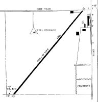
| A110-1 | UNLGTD 200 FT AND ANT 7500 FT SW OF RY 03. |
| A110-2 | FOR CD CTC KANSAS CITY ARTCC AT 913-254-8508. |
| A52-03 | OIL WELL 160 FT S OF RY 03; GRAIN ELEVATORS 1 MI S; TWR 1 MI SW. |
| A58-03 | OIL PUMP RIG AT 130 FT FROM RY END; 65 FT LEFT OF CNTRLN - LGTD +15 FT. |
| A58-21 | ROAD AT 20' FM RY END. |
| A70-FUEL-10 | 0LL FUEL SELF SVC 24 HR WITH CREDIT CARD. |
| A81-APT | ACTVT MIRL RY 03/21 - CTAF. |
Runways
Runway Summary
| Runways: | 03/21 |
| Longest Runway: | 03/21 is 3250 ft (991 m) long |
| Runways with an Instrument Approach: |
1K9 Airport Runway Details
| Runway 03/21 | 3250 ft x 40 ft (991 m x 12 m) | |
| Surface: | Asphalt - Good condition - No special surface treatment | |
| Runway Pavement Class: | 5 /F/C/Y/U | |
| Runway Edge Lights: | Medium Intensity | |
Runway 03 |
Runway 21 |
|
Elevation: |
2968.0 | 2972.0 |
Latitude: |
37-27-11.6900N | 37-27-36.3700N |
Longitude: |
100-59-17.5300W | 100-58-51.7100W |
Glide Path Angle: |
0.0 degrees | 0.0 degrees |
Traffic Pattern: |
Left | Left |
Runway Markings Type: |
Basic | Basic |
Runway Markings Condition: |
Good | Good |
Services
Airframe Repair: |
Major |
Powerplant Repair: |
Major |
Bottled Oxygen: |
None |
Bulk Oxygen: |
None |
Fuel Available: |
100LL, Jet A |
Landing Fees: |
No |
Parking: |
Hangars and tiedowns available |
Maps & Diagrams
1K9 Sectional
Flight Planning
at skyvector.com
at skyvector.com