
Location
Latitude: |
32-000-41.0339N (32.011398) |
Longitude: |
034-53-12.1188E (34.8867) |
Elevation: |
135 feet MSL (41 m MSL) |
Magnetic Variation: |
5.1 E (as of April 2024 from WMM2020 model) |
Time Zone: |
UTC +2.0 (Standard Time) UTC +3.0 (Daylight Savings Time) |
Contacts
Manager: |
: |
Operations
Airport Status: |
Operational |
Facility Use: |
Public |
Type: |
Airport |
Traffic Pattern Altitude (MSL): |
1135 feet (346 m) |
Based Aircraft
Annual Operations (as of )
Communications
| Ben Gurion Tower: | 134.6 |
| Ben Gurion Ground: | 118.05 |
| Ben Gurion Ground/Delivery: | 129.2 |
| Ben Gurion Approach: | 120.5 |
| ATIS: | 132.5 |
| Tel Aviv Control: | 121.4 |
Fixed Based Operators (FBOs) & Fuel
(Click on a business for detail)
Please help us keep this information up to date. This is a FREE SERVICE just like everything else on Airport Guide! If you see that a business needs to be added, modified, or deleted please fill out our Update Form.
To add, modify, or delete a business click here.
Please help us keep this information up to date. This is a FREE SERVICE just like everything else on Airport Guide! If you see that a business needs to be added, modified, or deleted please fill out our Update Form.
| Business Name | Frequency | Phone | Fuel Grade |
|---|
Flight Service Stations
| Primary | Alternate | |
| FSS on Field: | ||
| FSS Name (ID): | ||
| Frequency: | ||
| Toll Free Phone: |
Instrument Procedures / Charts
Terminal Procedures are only available for airports in several countries with more being added all the time. If you are looking for a specific country's charts, please send an email to support(at)airportguide.com stating the country name. This will be used to prioritize the implementation.
Navigation Aids (Navaids) near TLV
| Dist (NM) | ID | Morse Code | Name | Type | Freq | True Hdg | Mag Hdg |
|---|---|---|---|---|---|---|---|
| 0.6 | BGN | Ben Gurion | VOR-DME | 113.50 | 279 | 274 | |
| 6.6 | LL | Tel Aviv | NDB | 331 | 297 | 292 | |
| 8.0 | TAV | Sde Dov | NDB | 348 | 317 | 312 | |
| 10.5 | HRZ | Herzlia | NDB | 273 | 343 | 338 | |
| 19.0 | IRM | Jerusalem | NDB | 336 | 117 | 112 | |
| 19.7 | NAT | Natania | VOR-DME | 112.40 | 12 | 7 | |
| 44.3 | BSA | Beer-Sheba | VOR | 114.30 | 191 | 186 | |
| 48.3 | MZD | Metzada | VOR-DME | 115.00 | 147 | 142 | |
| 49.1 | HFA | Haifa | NDB | 323 | 10 | 5 | |
| 52.3 | MDB | Queen Alia | NDB | 399 | 110 | 105 | |
| 53.0 | RFH | Gaza | NDB | 380 | 215 | 210 | |
| 55.7 | GZA | Gaza | VOR-DME | 113.35 | 214 | 209 | |
| 60.0 | JYO | Amman | NDB | 391 | 90 | 85 | |
| 60.0 | AMN | Amman | VOR-DME | 116.30 | 90 | 85 | |
| 60.4 | QL | Queen Alia (Locator) | NDB | 307 | 105 | 100 | |
| 63.8 | QA | Queen Alia | NDB | 410 | 104 | 99 | |
| 66.6 | RPN | Rosh Pina | NDB | 243 | 30 | 25 | |
| 66.8 | QAA | Queen Alia | VOR-DME | 115.20 | 103 | 98 | |
| 67.8 | ROP | Rosh Pina | VOR-DME | 115.30 | 30 | 25 | |
| 74.8 | JYT | Qatraneh | NDB | 302 | 127 | 122 |
Nearby Airports with Fuel
| Dist (NM) | Name (Airport IDs) | True Hdg | Mag Hdg | Fuel Grade |
|---|
Notices to Airmen (NOTAMS)
Remarks
No remarks for this landing facility
Runways
Runway Summary
| Runways: | 03/21 08/26 12/30 |
| Longest Runway: | 08/26 is 13327 ft (4062 m) long |
| Runways with an Instrument Approach: |
TLV Airport Runway Details
| Runway 03/21 | 9094 ft x 197 ft (2772 m x 60 m) | |
| Runway Edge Lights: | Yes Intensity | |
Runway 03 |
Runway 21 |
|
Elevation: |
129 | 134 |
Latitude: |
31.99621582031 | 32.01812362670 |
Longitude: |
34.886081695556 | 34.900226593017 |
|
Runway True Alignment: |
29 | 209 |
Glide Path Angle: |
0.0 degrees | 0.0 degrees |
REIL: |
Yes | Yes |
Threshold Elevation: |
129 | 134 |
| Runway 08/26 | 13327 ft x 148 ft (4062 m x 45 m) | |
| Runway Edge Lights: | Yes Intensity | |
Runway 08 |
Runway 26 |
|
Elevation: |
97 | 124 |
Latitude: |
32.01300048828 | 32.01890182495 |
Longitude: |
34.860401153564 | 34.898601531982 |
|
Runway True Alignment: |
80 | 260 |
Glide Path Angle: |
0.0 degrees | 0.0 degrees |
REIL: |
Yes | Yes |
Threshold Elevation: |
97 | 124 |
Displaced Threshold: |
1969 |
| Runway 12/30 | 10209 ft x 148 ft (3112 m x 45 m) | |
| Runway Edge Lights: | Yes Intensity | |
Runway 12 |
Runway 30 |
|
Elevation: |
112 | 130 |
Latitude: |
32.01470184326 | 31.99990081787 |
Longitude: |
34.865798950195 | 34.894199371337 |
|
Runway True Alignment: |
121.4 | 301.4 |
Glide Path Angle: |
0.0 degrees | 0.0 degrees |
REIL: |
Yes | Yes |
Threshold Elevation: |
112 | 130 |
Displaced Threshold: |
246 |
Services
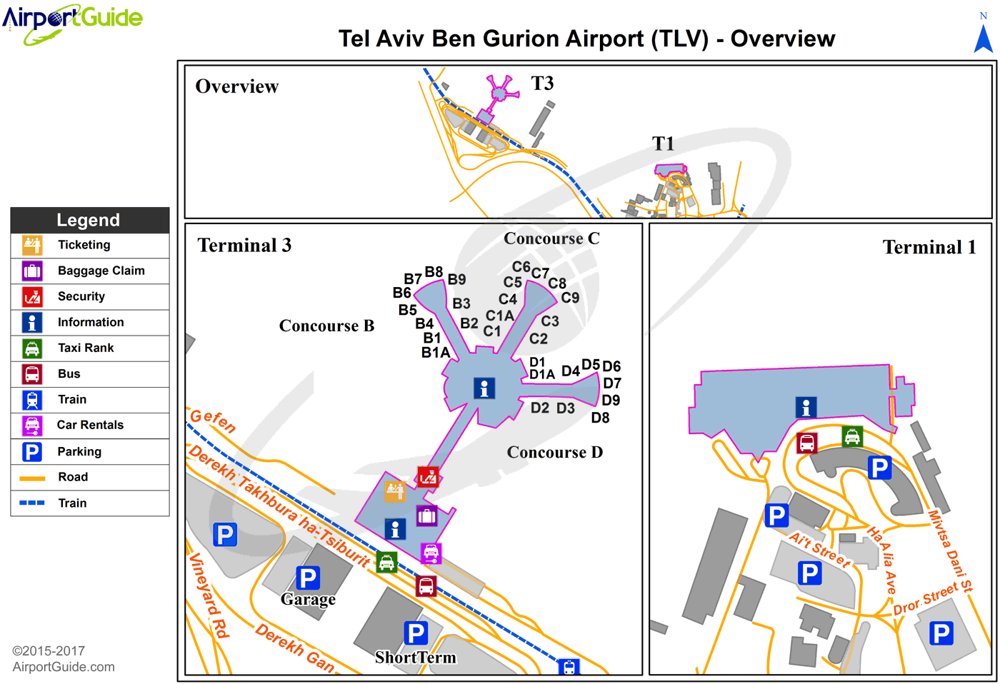
Maps & Diagrams
TLV Sectional
Flight Planning
at skyvector.com
at skyvector.com
