
Location
Latitude: |
53-52-56.9989N (53.8825) |
Longitude: |
028-01-50.5225E (28.030701) |
Elevation: |
670 feet MSL (204 m MSL) |
Magnetic Variation: |
9 E (as of April 2024 from WMM2020 model) |
Time Zone: |
UTC +2.0 (Standard Time) UTC +3.0 (Daylight Savings Time) |
Contacts
Manager: |
: |
Operations
Airport Status: |
Operational |
Facility Use: |
Public |
Type: |
Airport |
Traffic Pattern Altitude (MSL): |
1670 feet (509 m) |
Based Aircraft
Annual Operations (as of )
Communications
| TWR: | 118.3 |
| GND: | 121.7 |
| MINSK APP: | 125.9 |
| MINSK RADAR: | 125.25 |
| ATIS: | 128.85 |
| MINSK VOLMET: | 126.675 |
Fixed Based Operators (FBOs) & Fuel
(Click on a business for detail)
Please help us keep this information up to date. This is a FREE SERVICE just like everything else on Airport Guide! If you see that a business needs to be added, modified, or deleted please fill out our Update Form.
To add, modify, or delete a business click here.
Please help us keep this information up to date. This is a FREE SERVICE just like everything else on Airport Guide! If you see that a business needs to be added, modified, or deleted please fill out our Update Form.
| Business Name | Frequency | Phone | Fuel Grade |
|---|
Flight Service Stations
| Primary | Alternate | |
| FSS on Field: | ||
| FSS Name (ID): | ||
| Frequency: | ||
| Toll Free Phone: |
Instrument Procedures / Charts
Terminal Procedures are only available for airports in several countries with more being added all the time. If you are looking for a specific country's charts, please send an email to support(at)airportguide.com stating the country name. This will be used to prioritize the implementation.
Navigation Aids (Navaids) near MSQ
| Dist (NM) | ID | Morse Code | Name | Type | Freq | True Hdg | Mag Hdg |
|---|---|---|---|---|---|---|---|
| 0.4 | MNS | Minsk-2 | VOR-DME | 113.60 | 295 | 286 | |
| 3.1 | VX | Minsk-2 | NDB | 635 | 320 | 311 | |
| 3.2 | GH | Minsk-2 | NDB | 635 | 137 | 128 | |
| 15.3 | NE | Minsk-1 | NDB | 321 | 259 | 250 | |
| 17.3 | QM | Machulishchi | NDB | 458 | 257 | 248 | |
| 17.8 | WN | Machulishchi | NDB | 458 | 237 | 228 | |
| 19.7 | GK | Minsk-1 | NDB | 321 | 272 | 263 | |
| 45.9 | KI | Ivenets | NDB | 355 | 270 | 261 | |
| 71.4 | UF | Mogilev | NDB | 485 | 84 | 75 | |
| 74.8 | CO | Mogilev | NDB | 485 | 87 | 78 |
Nearby Airports with Fuel
| Dist (NM) | Name (Airport IDs) | True Hdg | Mag Hdg | Fuel Grade |
|---|
Notices to Airmen (NOTAMS)
Remarks
No remarks for this landing facility
Runways
Runway Summary
| Runways: | 13L/31R 13R/31L |
| Longest Runway: | 13L/31R is 12139 ft (3700 m) long |
| Runways with an Instrument Approach: |
MSQ Airport Runway Details
| Runway 13L/31R | 12139 ft x 197 ft (3700 m x 60 m) | |
| Runway Edge Lights: | Yes Intensity | |
Runway 13L |
Runway 31R |
|
Elevation: |
646 | 681 |
Latitude: |
53.90530014038 | 53.88029861450 |
Longitude: |
28.033300399780 | 28.070400238037 |
|
Runway True Alignment: |
138 | 318 |
Glide Path Angle: |
0.0 degrees | 0.0 degrees |
REIL: |
Yes | Yes |
Threshold Elevation: |
646 | 681 |
| Runway 13R/31L | 11946 ft x 197 ft (3641 m x 60 m) | |
| Runway Edge Lights: | Yes Intensity | |
Runway 13R |
Runway 31L |
|
Elevation: |
639 | 669 |
Latitude: |
53.89476013183 | 53.87016677856 |
Longitude: |
28.012470245361 | 28.048967361450 |
|
Runway True Alignment: |
139 | 319 |
Glide Path Angle: |
0.0 degrees | 0.0 degrees |
REIL: |
Yes | Yes |
Threshold Elevation: |
639 | 669 |
Services
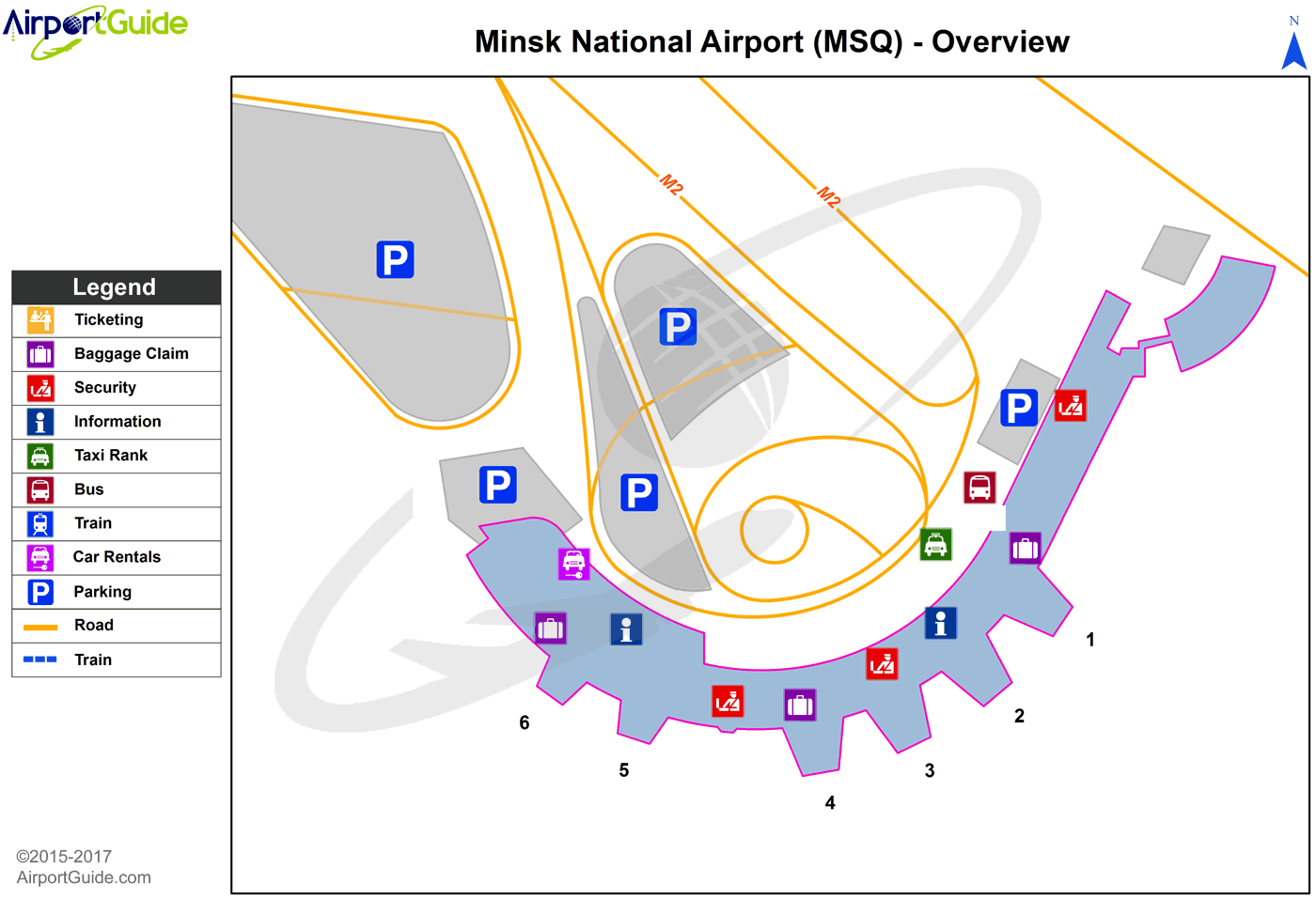
Maps & Diagrams
MSQ Sectional
Flight Planning
at skyvector.com
at skyvector.com
