Location
Latitude: |
65-10-27.8000N (65.174389) |
Longitude: |
152-06-29.2000W (-152.108111) |
Elevation: |
242.3 feet MSL (74 m MSL) |
Magnetic Variation: |
14 E (as of April 2024 from WMM2020 model) |
Time Zone: |
UTC -9.0 (Standard Time) UTC -8.0 (Daylight Savings Time) |
From City: |
01 N.M. WNW of Tanana, Alaska |
Found On: |
Fairbanks Chart |
FAA Region: |
AAL |
Contacts
Manager: |
Publicly owned: |
| JASON LUDINGTON 2301 PEGER ROAD FAIRBANKS, AK 99709 (907) 451-5280 |
ALASKA DOT&PF NORTHERN REGION 2301 PEGER RD FAIRBANKS, AK 99709 (907) 451-5280 |
Operations
Airport Status: |
Operational |
Facility Use: |
Public |
Type: |
Airport |
Activation Date: |
09/1947 |
Control tower: |
No |
Attendance (Months/Days/Hours): |
Months/Days/Hours Unattended |
Boundary ARTCC: |
ZAN (Anchorage) |
Responsible ARTCC: |
ZAN (Anchorage) |
Lighting Schedule: |
SEE RMK |
Segmented Circle Indicator: |
Yes |
Traffic Pattern Altitude (MSL): |
1242 feet (379 m) |
NOTAMs Facility: |
TAL |
NOTAM-D Service: |
Yes |
International Airport of Entry: |
No |
Customs Landing Rights: |
No |
Military Landing Rights: |
Yes |
Civil/Military Joint Use: |
No |
Based Aircraft
Annual Operations (as of 12/31/2022)
| Total Operations: | 3100 | |
| Air Taxi: | 1350 | 43.5% |
| GA Local: | 1200 | 38.7% |
| GA Itinerant: | 500 | 16.1% |
| Military Aircraft: | 50 | 1.6% |
Communications
| CTAF: | 122.900 |
| ASOS: | 135.1 (907-366-7266) |
- APCH/DEP SVC PRVDD BY ANCHORAGE ARTCC ON FREQS 120.9/285.4 (MURPHY DOME RCAG).
- COMMUNICATIONS PRVDD BY FAIRBANKS FSS ON FREQ 122.65 (TANANA RCO).
Fixed Based Operators (FBOs) & Fuel
(Click on a business for detail)
Please help us keep this information up to date. This is a FREE SERVICE just like everything else on Airport Guide! If you see that a business needs to be added, modified, or deleted please fill out our Update Form.
To add, modify, or delete a business click here.
Please help us keep this information up to date. This is a FREE SERVICE just like everything else on Airport Guide! If you see that a business needs to be added, modified, or deleted please fill out our Update Form.
Area Code: 907 |
| Business Name | Frequency | Phone | Fuel Grade |
|---|
Flight Service Stations
| Primary | Alternate | |
| FSS on Field: | N | |
| FSS Name (ID): | Fairbanks(FAI) | |
| Frequency: | ||
| Toll Free Phone: | 1-866-248-6516 |
Instrument Procedures / Charts
FAA Terminal Procedures valid from 0901Z 03/21/24 to 0901Z 04/18/24.
There are various types of charts available for an airport. They are listed in the Page Type column. Here is a legend for those types:
APD - Airport Diagram
DP - Departure Procedure Charts
HOT - Hot Spots
IAP - Instrument Approach Procedure Charts
MIN - Minimums
STAR - Standard Terminal Arrival Charts
| Page Type | Page Name | Volume | Action Since Last Cycle |
|---|---|---|---|
| IAP | RNAV (GPS) RWY 07 | AK-1 | Changed |
| IAP | VOR/DME RWY 07 | AK-1 | |
| MIN | ALTERNATE MINIMUMS | AK-1 | |
| MIN | TAKEOFF MINIMUMS | AK-1 |
Terminal Procedures are only available for airports in several countries with more being added all the time. If you are looking for a specific country's charts, please send an email to support(at)airportguide.com stating the country name. This will be used to prioritize the implementation.
Navigation Aids (Navaids) near TAL
| Dist (NM) | ID | Morse Code | Name | Type | Freq | True Hdg | Mag Hdg |
|---|---|---|---|---|---|---|---|
| 1.8 | TAL | _ . _ . _ . . | Tanana | VOR-DME | 116.60 | 275 | 261 |
| 2.5 | BCC | _ . . . _ . _ . _ . _ . | Bear Creek | NDB | 212 | 269 | 255 |
| 63.0 | UTO | . . _ _ _ _ _ | Utopia Creek | NDB-DME | 272 | 322 | 308 |
| 77.6 | MHM | _ _ . . . . _ _ | Minchumina | NDB | 227 | 184 | 170 |
| 84.9 | ENN | . _ . _ . | Nenana | VORTAC | 115.80 | 113 | 98 |
| 86.0 | ICW | . . _ . _ . . _ _ | Ice Pool | NDB | 525 | 114 | 99 |
Nearby Airports with Fuel
| Dist (NM) | Name (Airport IDs) | True Hdg | Mag Hdg | Fuel Grade |
|---|---|---|---|---|
| 86.0 | Nenana Municipal Airport (ENN PANN ENN) |
114 | 99 | 100LL, Jet A |
Notices to Airmen (NOTAMS)
Remarks
| A110-1 | SNOW REMOVAL OPERATIONS DURING WINTER--MONITOR CTAF. |
| A110-2 | RY COND NOT MONITORED; RECOMMEND VISUAL INSPECTION PRIOR TO LANDING. |
| A110-3 | FLOATPLANE TFC IN RIVER ADJ TO ARPT. |
| A110-4 | WX OBSERVER AVBL FOR LOCAL ARPT WX ON CTAF (CALL SIGN: TANANA WEATHER) & PHONE 907-366-7288 0600-2130. |
| A110-5 | WX CAMERA AVBL ON INTERNET AT HTTPS://WEATHERCAMS.FAA.GOV |
| A110-6 | TWY B CLOSED DURING WINTER MONTHS. |
| A110-7 | TWY B UNLIT. |
| A110-8 | TWY B REFLECTORS 36 INCHES TALL. |
| A81-APT | ACTVT MIRL RY 07/25 & VASI RY 07 - CTAF. |
Runways
Runway Summary
| Runways: | 07/25 |
| Longest Runway: | 07/25 is 4400 ft (1341 m) long |
| Runways with an Instrument Approach: |
TAL Airport Runway Details
| Runway 07/25 | 4400 ft x 100 ft (1341 m x 30 m) | |
| Runway Length Source: | 3RD PARTY SURVEY as of 07/13/2010 | |
| Surface: | Gravel - Good condition - No special surface treatment | |
| Runway Edge Lights: | Medium Intensity | |
Runway 07 |
Runway 25 |
|
Elevation: |
229.6 | 242.3 |
Latitude: |
65-10-27.5764N | 65-10-28.0872N |
Longitude: |
152-07-20.7022W | 152-05-37.6993W |
|
Runway True Alignment: |
089 | 269 |
Glide Path Angle: |
3.0 degrees | 0.0 degrees |
Traffic Pattern: |
Right | Left |
Runway Markings Type: |
Nonstandard (other than numbers only) | Nonstandard (other than numbers only) |
Object at End: |
BRUSH | BRUSH |
Object Height: |
2 | 12 |
Distance from End: |
0 | 0 |
Object Centerline Offset: |
190 ft. right of centerline | 180 ft. left and right of centerline |
Visual Glide Slope Indicators: |
4-Box VASI On Left Side Of Runway | |
Threshold Crossing Height: |
24 |
Services
Airframe Repair: |
None |
Powerplant Repair: |
None |
Bottled Oxygen: |
None |
Bulk Oxygen: |
None |
Fuel Available: |
100LL, Jet A |
Landing Fees: |
No |
Parking: |
Tiedowns available |
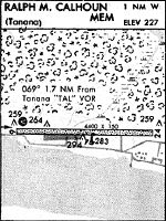
Maps & Diagrams
TAL Sectional
Flight Planning
at skyvector.com
at skyvector.com