
Location
Latitude: |
36-53-55.3236N (36.898701) |
Longitude: |
030-48-01.8036E (30.800501) |
Elevation: |
177 feet MSL (54 m MSL) |
Magnetic Variation: |
5.6 E (as of April 2024 from WMM2020 model) |
Time Zone: |
UTC +2.0 (Standard Time) UTC +3.0 (Daylight Savings Time) |
Contacts
Manager: |
: |
Operations
Airport Status: |
Operational |
Facility Use: |
Public / Military |
Type: |
Airport |
Traffic Pattern Altitude (MSL): |
1177 feet (359 m) |
Based Aircraft
Annual Operations (as of )
Communications
| TWR east: | 125 |
| TWR west: | 126.1 |
| CLNC DEL: | 123.175 |
| GND: | 121.9 |
| ATIS: | 118.275 |
| upper: | 122.05 |
| arrival: | 119.65 |
| Handling Services: | 131.45 |
| Malden Grond: | 123.35 |
Fixed Based Operators (FBOs) & Fuel
(Click on a business for detail)
Please help us keep this information up to date. This is a FREE SERVICE just like everything else on Airport Guide! If you see that a business needs to be added, modified, or deleted please fill out our Update Form.
To add, modify, or delete a business click here.
Please help us keep this information up to date. This is a FREE SERVICE just like everything else on Airport Guide! If you see that a business needs to be added, modified, or deleted please fill out our Update Form.
| Business Name | Frequency | Phone | Fuel Grade |
|---|
Flight Service Stations
| Primary | Alternate | |
| FSS on Field: | ||
| FSS Name (ID): | ||
| Frequency: | ||
| Toll Free Phone: |
Instrument Procedures / Charts
Terminal Procedures are only available for airports in several countries with more being added all the time. If you are looking for a specific country's charts, please send an email to support(at)airportguide.com stating the country name. This will be used to prioritize the implementation.
Navigation Aids (Navaids) near AYT
| Dist (NM) | ID | Morse Code | Name | Type | Freq | True Hdg | Mag Hdg |
|---|---|---|---|---|---|---|---|
| 1.3 | AYT | Antalya | TACAN | 115.50 | 320 | 314 | |
| 1.4 | AYT | Antalya | VOR-DME | 114.00 | 350 | 344 | |
| 1.5 | YT | Antalya | NDB | 302 | 202 | 196 | |
| 1.5 | ANT | Antalya | DME | 109.10 | 201 | 195 | |
| 16.6 | GEY | Antalya | NDB | 413 | 265 | 259 | |
| 60.9 | IPT | Isparta | VOR-DME | 117.50 | 339 | 333 | |
| 61.0 | IPT | Isparta | NDB | 349 | 339 | 333 | |
| 74.5 | KZO | Kastelorizo | NDB | 416 | 232 | 227 | |
| 74.7 | CRD | Cardak | TACAN | 133.30 | 315 | 309 | |
| 74.8 | CRD | Cardak | VOR-DME | 112.00 | 315 | 309 | |
| 74.8 | CRD | Cardak | NDB | 433 | 315 | 309 | |
| 97.3 | DAL | Dalaman | TACAN | 115.30 | 264 | 258 | |
| 97.8 | DAL | Dalaman | NDB | 346 | 263 | 257 | |
| 97.8 | DAL | Dalaman | VOR-DME | 114.70 | 263 | 257 |
Nearby Airports with Fuel
| Dist (NM) | Name (Airport IDs) | True Hdg | Mag Hdg | Fuel Grade |
|---|
Notices to Airmen (NOTAMS)
Remarks
No remarks for this landing facility
Runways
Runway Summary
| Runways: | 18C/36C 18L/36R 18R/36L |
| Longest Runway: | 18C/36C is 11155 ft (3400 m) long |
| Runways with an Instrument Approach: |
AYT Airport Runway Details
| Runway 18C/36C | 11155 ft x 148 ft (3400 m x 45 m) | |
| Runway Edge Lights: | Yes Intensity | |
Runway 18C |
Runway 36C |
|
Elevation: |
176 | 176 |
Latitude: |
36.91550064086 | 36.88510131835 |
Longitude: |
30.794700622558 | 30.790599822998 |
|
Runway True Alignment: |
186 | 6 |
Glide Path Angle: |
0.0 degrees | 0.0 degrees |
REIL: |
Yes | Yes |
Threshold Elevation: |
176 | 176 |
| Runway 18L/36R | 11155 ft x 148 ft (3400 m x 45 m) | |
| Runway Edge Lights: | Yes Intensity | |
Runway 18L |
Runway 36R |
|
Elevation: |
176 | 158 |
Latitude: |
36.91139984130 | 36.88090133666 |
Longitude: |
30.811399459838 | 30.807199478149 |
|
Runway True Alignment: |
186 | 6 |
Glide Path Angle: |
0.0 degrees | 0.0 degrees |
REIL: |
Yes | Yes |
Threshold Elevation: |
176 | 158 |
| Runway 18R/36L | 9811 ft x 148 ft (2990 m x 45 m) | |
| Runway Edge Lights: | Yes Intensity | |
Runway 18R |
Runway 36L |
|
Elevation: |
172 | 176 |
Latitude: |
36.91569900512 | 36.88899993896 |
Longitude: |
30.792400360107 | 30.788700103759 |
|
Runway True Alignment: |
186 | 6 |
Glide Path Angle: |
0.0 degrees | 0.0 degrees |
REIL: |
Yes | Yes |
Threshold Elevation: |
172 | 176 |
Services
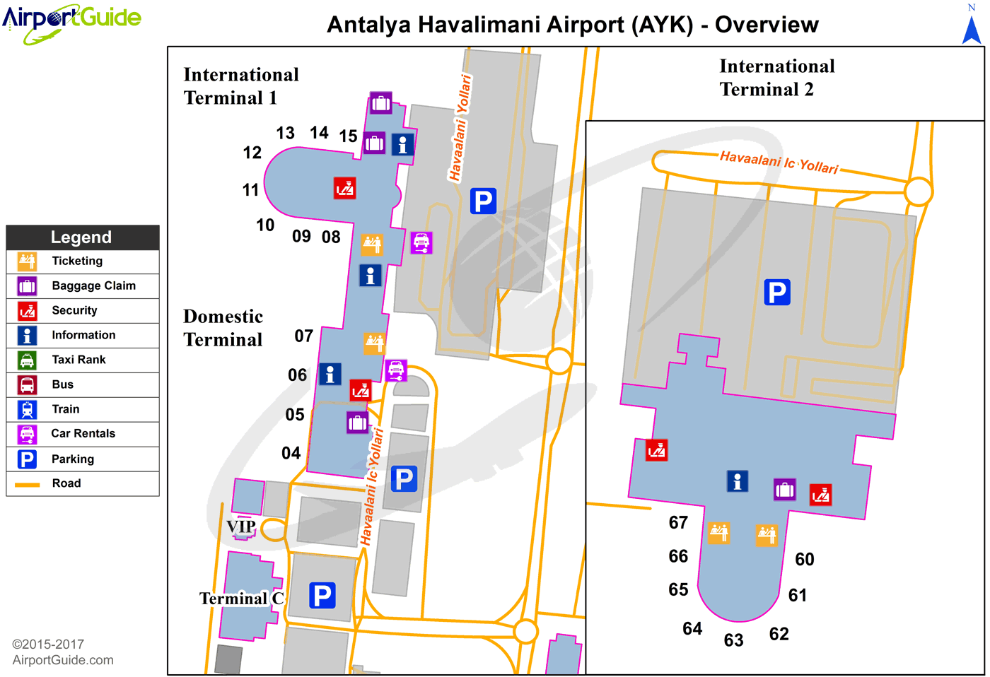
Maps & Diagrams
AYT Sectional
Flight Planning
at skyvector.com
at skyvector.com
