Location
Latitude: |
42-34-45.5464N (42.579318) |
Longitude: |
121-52-44.4510W (-121.879014) |
Elevation: |
4221.0 feet MSL (1287 m MSL) |
Magnetic Variation: |
14 E (as of April 2024 from WMM2020 model) |
Time Zone: |
UTC -8.0 (Standard Time) UTC -7.0 (Daylight Savings Time) |
From City: |
01 N.M. W of Chiloquin, Oregon |
Found On: |
Klamath Falls Chart |
FAA Region: |
ANM |
Contacts
Manager: |
Publicly owned: |
| STATE AIRPORTS MGR 3040 25TH ST, SE SALEM, OR 97302-1125 503-378-4880 |
OREGON DEPT. OF AVIATION 3040 25TH ST, SE SALEM, OR 97302-1125 503-378-4880 |
Operations
Airport Status: |
Operational |
Facility Use: |
Public |
Type: |
Airport |
Activation Date: |
01/1939 |
Control tower: |
No |
Attendance (Months/Days/Hours): |
Months/Days/Hours Unattended |
Boundary ARTCC: |
ZSE (Seattle) |
Responsible ARTCC: |
ZSE (Seattle) |
Lighting Schedule: |
SEE RMK |
Segmented Circle Indicator: |
Yes |
Traffic Pattern Altitude (MSL): |
5221 feet (1591 m) |
NOTAMs Facility: |
MMV |
NOTAM-D Service: |
Yes |
International Airport of Entry: |
No |
Customs Landing Rights: |
No |
Military Landing Rights: |
No |
Civil/Military Joint Use: |
No |
Based Aircraft
| Single Engine: | 7 |
Annual Operations (as of 06/11/2019)
| Total Operations: | 3500 | |
| Air Taxi: | 500 | 14.3% |
| GA Local: | 300 | 8.6% |
| GA Itinerant: | 2700 | 77.1% |
Communications
| CTAF: | 122.900 |
Fixed Based Operators (FBOs) & Fuel
(Click on a business for detail)
Please help us keep this information up to date. This is a FREE SERVICE just like everything else on Airport Guide! If you see that a business needs to be added, modified, or deleted please fill out our Update Form.
To add, modify, or delete a business click here.
Please help us keep this information up to date. This is a FREE SERVICE just like everything else on Airport Guide! If you see that a business needs to be added, modified, or deleted please fill out our Update Form.
Area Code: 503 |
| Business Name | Frequency | Phone | Fuel Grade |
|---|
Flight Service Stations
| Primary | Alternate | |
| FSS on Field: | N | |
| FSS Name (ID): | Mc Minnville(MMV) | |
| Frequency: | ||
| Toll Free Phone: | 1-800-WX-BRIEF |
Instrument Procedures / Charts
Terminal Procedures are only available for airports in several countries with more being added all the time. If you are looking for a specific country's charts, please send an email to support(at)airportguide.com stating the country name. This will be used to prioritize the implementation.
Navigation Aids (Navaids) near CHZ
| Dist (NM) | ID | Morse Code | Name | Type | Freq | True Hdg | Mag Hdg |
|---|---|---|---|---|---|---|---|
| 26.4 | LMT | . _ . . _ _ _ | Klamath Falls | VORTAC | 115.90 | 165 | 151 |
| 45.6 | MEF | _ _ . . . _ . | Medford | NDB | 356 | 256 | 242 |
| 45.7 | MFR | _ _ . . _ . . _ . | Medford | VOT | 117.20 | 253 | 239 |
| 46.1 | OED | _ _ _ . _ . . | Rogue Valley | VORTAC | 113.60 | 262 | 248 |
| 57.7 | MOG | _ _ _ _ _ _ _ . | Montague | NDB | 404 | 207 | 193 |
| 60.9 | LKV | . _ . . _ . _ . . . _ | Lakeview | VORTAC | 112.00 | 94 | 80 |
| 74.2 | RBG | . _ . _ . . . _ _ . | Roseburg | VOR-DME | 108.20 | 299 | 285 |
| 76.0 | RBG | . _ . _ . . . _ _ . | Roseburg | NDB | 400 | 301 | 287 |
| 79.4 | FJS | . . _ . . _ _ _ . . . | Fort Jones | VOR-DME | 116.25 | 211 | 197 |
Nearby Airports with Fuel
Notices to Airmen (NOTAMS)
Remarks
| A110-2 | DOWNDRAFT AREA NORTH OF RY. |
| A110-4 | IREG WINTER MAINTENANCE; ARPT CLSD WHEN COVERED IN SNOW. |
| A110-5 | WEST SIDE TWY MARKED WITH REFLECTORS. |
| A110-6 | SURFACE CONDITIONS NOT REPORTED. |
| A110-7 | FOR CD CTC SEATTLE ARTCC AT 253-351-3694. |
| A57-17 | RWY 17 APCH SLP 15:1 TO DTHR. |
| A81-APT | PILOT CONTROL LIGHTING (PCL) TO ACTVT MIRL RY 17/35 - CTAF. |
| E111 | ESTABLISHED PRIOR TO 1959. |
Runways
Runway Summary
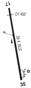
| Runways: | 17/35 |
| Longest Runway: | 17/35 is 3749 ft (1143 m) long |
| Runways with an Instrument Approach: |
CHZ Airport Runway Details
| Runway 17/35 | 3749 ft x 60 ft (1143 m x 18 m) | |
| Runway Length Source: | ADO as of 11/05/2012 | |
| Surface: | Asphalt - Good condition - No special surface treatment | |
| Runway Edge Lights: | Medium Intensity | |
Runway Weight Bearing Capacity (in thousands of pounds) |
||
| Single Wheel Landing Gear: | 10.0 | |
Runway 17 |
Runway 35 |
|
Elevation: |
4220.4 | 4191.8 |
Latitude: |
42-35-03.9645N | 42-34-27.1283N |
Longitude: |
121-52-41.8511W | 121-52-47.0508W |
Glide Path Angle: |
0.0 degrees | 0.0 degrees |
Traffic Pattern: |
Left | Left |
Runway Markings Type: |
Basic | Basic |
Runway Markings Condition: |
Good | Good |
Object at End: |
TREE | TREE |
Object Height: |
121 | 55 |
Distance from End: |
1410 | 1143 |
Object Centerline Offset: |
100 ft. left of centerline | 65 ft. right of centerline |
Threshold Elevation: |
4217.2 | |
Displaced Threshold: |
420 | |
Threshold Latitude: |
42-34-59.8379N | |
Threshold Longitude: |
121-52-42.4337W |
Services
Airframe Repair: |
None |
Bottled Oxygen: |
None |
Bulk Oxygen: |
None |
Fuel Available: |
100LL |
Landing Fees: |
No |
Parking: |
Tiedowns available |
Other Services: |
Aircraft salvage |
Maps & Diagrams
CHZ Sectional
Flight Planning
at skyvector.com
at skyvector.com