Location
Latitude: |
61-26-16.1487N (61.437819) |
Longitude: |
142-54-09.0108W (-142.902503) |
Elevation: |
1532.8 feet MSL (467 m MSL) |
Magnetic Variation: |
17 E (as of May 2024 from WMM2020 model) |
Time Zone: |
UTC -9.0 (Standard Time) UTC -8.0 (Daylight Savings Time) |
From City: |
01 N.M. NE of Mccarthy, Alaska |
Found On: |
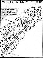
Anchorage Chart |
FAA Region: |
AAL |
Contacts
Manager: |
Publicly owned: |
| CHAD HELLER PO BOX 7 GLENALLEN, AK 99588 907-822-3222 |
ALASKA DOT&PF NORTHERN REGION 2301 PEGER ROAD FAIRBANKS, AK 99709 907-451-2200 |
Operations
Airport Status: |
Operational |
Facility Use: |
Public |
Type: |
Airport |
Control tower: |
No |
Attendance (Months/Days/Hours): |
Months/Days/Hours Unattended |
Boundary ARTCC: |
ZAN (Anchorage) |
Responsible ARTCC: |
ZAN (Anchorage) |
Segmented Circle Indicator: |
Yes |
Traffic Pattern Altitude (MSL): |
2533 feet (772 m) |
NOTAMs Facility: |
MXY |
NOTAM-D Service: |
Yes |
International Airport of Entry: |
No |
Customs Landing Rights: |
No |
Military Landing Rights: |
Yes |
Civil/Military Joint Use: |
No |
Based Aircraft
Annual Operations (as of 12/31/2021)
| Total Operations: | 1400 | |
| Air Taxi: | 500 | 35.7% |
| GA Local: | 500 | 35.7% |
| GA Itinerant: | 400 | 28.6% |
Communications
| CTAF: | 122.900 |
Fixed Based Operators (FBOs) & Fuel
(Click on a business for detail)
Please help us keep this information up to date. This is a FREE SERVICE just like everything else on Airport Guide! If you see that a business needs to be added, modified, or deleted please fill out our Update Form.
To add, modify, or delete a business click here.
Please help us keep this information up to date. This is a FREE SERVICE just like everything else on Airport Guide! If you see that a business needs to be added, modified, or deleted please fill out our Update Form.
Area Code: 907 |
| Business Name | Frequency | Phone | Fuel Grade |
|---|
Flight Service Stations
| Primary | Alternate | |
| FSS on Field: | N | |
| FSS Name (ID): | Kenai(ENA) | |
| Frequency: | ||
| Toll Free Phone: | 1-866-864-1737 |
Instrument Procedures / Charts
Terminal Procedures are only available for airports in several countries with more being added all the time. If you are looking for a specific country's charts, please send an email to support(at)airportguide.com stating the country name. This will be used to prioritize the implementation.
Navigation Aids (Navaids) near MXY
| Dist (NM) | ID | Morse Code | Name | Type | Freq | True Hdg | Mag Hdg |
|---|---|---|---|---|---|---|---|
| 81.7 | YXQ | _ . _ _ _ . . _ _ _ . _ | Beaver Creek | NDB | 239 | 43 | 26 |
| 82.0 | CYT | _ . _ . _ . _ _ _ | Yakataga | NDB | 209 | 171 | 154 |
| 84.0 | GKN | _ _ . _ . _ _ . | Gulkana | VOR-DME | 115.60 | 301 | 284 |
| 85.7 | GLA | _ _ . . _ . . . _ | Glennallen | NDB | 248 | 303 | 286 |
| 93.7 | GCR | _ _ . _ . _ . . _ . | Glacier River | NDB | 404 | 234 | 217 |
| 94.7 | ORT | _ _ _ . _ . _ | Northway | VORTAC | 116.30 | 16 | 359 |
| 94.8 | AES | . _ . . . . | Nabesna | NDB | 390 | 16 | 359 |
Nearby Airports with Fuel
| Dist (NM) | Name (Airport IDs) | True Hdg | Mag Hdg | Fuel Grade |
|---|---|---|---|---|
| 95.4 | Northway Airport (ORT PAOR ORT) |
16 | 359 | 100LL, Jet A |
| 98.1 | Cordova Municipal Airport (CKU CKU) |
238 | 222 | 100LL |
Notices to Airmen (NOTAMS)
Remarks
| A110-3 | RWY COND UNMNT; RCMD VISUAL INSP PRIOR TO LNDG. |
| A110-6 | WILDLIFE INVOF RWY. |
| A30A-01 | APCH OVR OLD MCCARTHY ARPT. |
| A52-19 | MT 2 MI FM RWY. |
Runways
Runway Summary
| Runways: | 01/19 |
| Longest Runway: | 01/19 is 3501 ft (1067 m) long |
| Runways with an Instrument Approach: |
MXY Airport Runway Details
| Runway 01/19 | 3501 ft x 60 ft (1067 m x 18 m) | |
| Surface: | Gravel/Dirt - Fair condition - No special surface treatment | |
Runway 01 |
Runway 19 |
|
Elevation: |
1531.0 | 1522.4 |
Latitude: |
61-26-02.5772N | 61-26-29.7201N |
Longitude: |
142-54-31.2036W | 142-53-46.8180W |
Glide Path Angle: |
0.0 degrees | 0.0 degrees |
Traffic Pattern: |
Left | Left |
Runway Markings Type: |
Nonstandard (other than numbers only) | Nonstandard (other than numbers only) |
Object at End: |
BRUSH | BRUSH |
Object Height: |
6 | 7 |
Distance from End: |
0 | 0 |
Object Centerline Offset: |
90 ft. left and right of centerline | 110 ft. right of centerline |
Services
Airframe Repair: |
Major |
Powerplant Repair: |
Major |
Bottled Oxygen: |
None |
Bulk Oxygen: |
None |
Fuel Available: |
100LL |
Landing Fees: |
No |
Parking: |
Tiedowns available |
Maps & Diagrams
MXY Sectional
Flight Planning
at skyvector.com
at skyvector.com