Location
Latitude: |
21-09-10.3890N (21.152886) |
Longitude: |
157-05-46.5220W (-157.096256) |
Elevation: |
453.9 feet MSL (138 m MSL) |
Magnetic Variation: |
9.5 E (as of April 2024 from WMM2020 model) |
Time Zone: |
UTC -10.0 (Standard Time) UTC -10.0 (Daylight Savings Time) |
From City: |
06 N.M. NW of Kaunakakai, Hawaii |
Found On: |
Hawaiian Islands Chart |
FAA Region: |
AWP |
Contacts
Manager: |
Publicly owned: |
| MARVIN MONIZ KAHULUI ARPT KAHULUI, HI 96732 808-872-3808 |
HAWAII STATE AIRPORTS DIV HONOLULU INTL ARPT HONOLULU, HI 96819 808-836-6432 |
Operations
Airport Status: |
Operational |
Facility Use: |
Public |
Type: |
Airport |
Activation Date: |
07/1946 |
Control tower: |
Yes |
Attendance (Months/Days/Hours): |
Months/Days/Hours ALL/ALL/0500-2015 |
Boundary ARTCC: |
ZHN (Honolulu Control Facility) |
Responsible ARTCC: |
ZHN (Honolulu Control Facility) |
Lighting Schedule: |
SEE RMK |
Segmented Circle Indicator: |
Yes |
Traffic Pattern Altitude (MSL): |
1454 feet (443 m) |
NOTAMs Facility: |
MKK |
NOTAM-D Service: |
Yes |
International Airport of Entry: |
No |
Customs Landing Rights: |
No |
Military Landing Rights: |
Yes |
Civil/Military Joint Use: |
No |
Aircraft Rescue and Firefighting: |
Class I ARFF Index: A Air Carrier Service: Scheduled Certification Date: 05/1973 |
Based Aircraft
| Single Engine: | 6 |
Annual Operations (as of 02/17/2022)
| Total Operations: | 26706 | |
| Air Taxi: | 21873 | 81.9% |
| GA Local: | 703 | 2.6% |
| GA Itinerant: | 3628 | 13.6% |
| Military Aircraft: | 502 | 1.9% |
Communications
| CTAF: | 125.700 |
| Tower: | MOLOKAI 125.7 306.2 Hrs: 0600-1830 |
| Ground: | 121.9 |
| Approach: | HCF CENTER |
| Departure: | HCF CENTER |
| ATIS: | 128.2 |
| ASOS: | (808-567-6106) |
| EMERG: | 121.5 |
| EMERG: | 243.0 |
- APCH/DEP SVC PRVDD BY HONOLULU CONTROL FACILITY (ZHN) ON FREQS 124.1/317.5 (MOUNT HALEAKALA RCAG).
Fixed Based Operators (FBOs) & Fuel
(Click on a business for detail)
Please help us keep this information up to date. This is a FREE SERVICE just like everything else on Airport Guide! If you see that a business needs to be added, modified, or deleted please fill out our Update Form.
To add, modify, or delete a business click here.
Please help us keep this information up to date. This is a FREE SERVICE just like everything else on Airport Guide! If you see that a business needs to be added, modified, or deleted please fill out our Update Form.
Area Code: 808 |
| Business Name | Frequency | Phone | Fuel Grade |
|---|
Flight Service Stations
| Primary | Alternate | |
| FSS on Field: | N | |
| FSS Name (ID): | Honolulu(HNL) | |
| Frequency: | ||
| Toll Free Phone: | 1-800-WX-BRIEF |
Instrument Procedures / Charts
FAA Terminal Procedures valid from 0901Z 03/21/24 to 0901Z 04/18/24.
There are various types of charts available for an airport. They are listed in the Page Type column. Here is a legend for those types:
APD - Airport Diagram
DP - Departure Procedure Charts
HOT - Hot Spots
IAP - Instrument Approach Procedure Charts
MIN - Minimums
STAR - Standard Terminal Arrival Charts
| Page Type | Page Name | Volume | Action Since Last Cycle |
|---|---|---|---|
| APD | AIRPORT DIAGRAM | PC-1 | |
| DP | BLUSH TWO | PC-1 | |
| DP | HAPAI THREE | PC-1 | |
| DP | KALAE ONE (RNAV) | PC-1 | |
| DP | MAULA ONE (RNAV) | PC-1 | |
| HOT | HOT SPOT | PC-1 | |
| IAP | RNAV (GPS)-B | PC-1 | |
| IAP | VOR OR TACAN-A | PC-1 | |
| MIN | ALTERNATE MINIMUMS | PC-1 | |
| MIN | DIVERSE VECTOR AREA | PC-1 | |
| MIN | TAKEOFF MINIMUMS | PC-1 | |
| ODP | KAUNAKAKAI ONE (OBSTACLE) | PC-1 | |
| ODP | KAUNAKAKAI ONE (OBSTACLE)[DELIMITER] CONT.1 | PC-1 |
Terminal Procedures are only available for airports in several countries with more being added all the time. If you are looking for a specific country's charts, please send an email to support(at)airportguide.com stating the country name. This will be used to prioritize the implementation.
Navigation Aids (Navaids) near MKK
| Dist (NM) | ID | Morse Code | Name | Type | Freq | True Hdg | Mag Hdg |
|---|---|---|---|---|---|---|---|
| 4.1 | MKK | _ _ _ . _ _ . _ | Molokai | VORTAC | 116.10 | 257 | 248 |
| 23.8 | LLD | . _ . . . _ . . _ . . | Lanai | NDB | 353 | 163 | 154 |
| 24.4 | LNY | . _ . . _ . _ . _ _ | Lanai | VORTAC | 117.70 | 162 | 153 |
| 34.6 | CKH | _ . _ . _ . _ . . . . | Koko Head | VORTAC | 113.90 | 281 | 272 |
| 40.1 | VYI | . . . _ _ . _ _ . . | Valley Island | NDB | 327 | 113 | 104 |
| 40.6 | OGG | _ _ _ _ _ . _ _ . | Maui | VORTAC | 115.10 | 111 | 102 |
| 41.2 | NGF | _ . _ _ . . . _ . | Kaneohe Bay | TACAN | 114.60 | 296 | 287 |
| 47.6 | HNL | . . . . _ . . _ . . | Honolulu | VORTAC | 114.80 | 281 | 272 |
| 47.7 | HNL | . . . . _ . . _ . . | Honolulu | VOT | 111.00 | 282 | 273 |
| 54.3 | HN | . . . . _ . | Ewabe | NDB | 242 | 281 | 272 |
| 55.9 | HHI | . . . . . . . . . . | Wheeler | NDB | 373 | 290 | 281 |
| 90.6 | UPP | . . _ . _ _ . . _ _ . | Upolu Point | VORTAC | 112.30 | 128 | 119 |
Nearby Airports with Fuel
| Dist (NM) | Name (Airport IDs) | True Hdg | Mag Hdg | Fuel Grade |
|---|---|---|---|---|
| 23.5 | Lanai Airport (LNY PHNY LNY) |
159 | 150 | Jet A |
| 40.3 | Kahului Airport (OGG PHOG OGG) |
112 | 103 | 100, Jet A |
| 47.1 | Daniel K Inouye International Airport (HNL PHNL HNL) |
282 | 273 | 100, Jet A, Jet A-1+ |
| 66.6 | Kawaihapai Airfield Airport (HDH PHDH HDH) |
292 | 283 | 100, Jet A |
Notices to Airmen (NOTAMS)
Remarks
| A110*G | THIS AIRPORT HAS BEEN SURVEYED BY THE NATIONAL GEODETIC SURVEY. |
| A110-1 | 24 HRS PPR FOR DIVISION 1.1,1.2,1.3 EXPLOSIVES AND 4 HRS PPR FOR OTHER HAZARDOUS MATERIAL IN/OUT OF ARPT CTC 808-567-6140/6008. |
| A110-2 | MTN APPROXIMATELY 1280' MSL LCTD 2.8 NM FROM RWY 05 THR ON CNTRLN EXTDD. |
| A110-3 | BE ALERT TO EGRETS AND PIGEONS ON & INVOF ARPT. |
| A110-4 | LARGE ACFT WITH WINGSPAN GREATER THAN 78 FT MAY NOT USE TWY A OR RY 05/23 FOR SIMULTANEOUS OPNS. |
| A110-5 | (E94) LAWRS AVBL FROM TWR PERSONNEL 0600-1900 LCL. |
| A110-6 | STANDING WATER/PONDING ON RY 17/35 NEAR TWY ECHO DURING INCLEMENT WEATHER. |
| A110-7 | FOR CD WHEN ATCT IS CLSD CTC HONOLULU CONTROL FACILITY AT 808-840-6262. |
| A110-8 | (CONTACT TITLE) ARPT OPNS/MAINT/AOM/MR. ANTONE KALILIKANE (808) 567-9660. |
| A26 | ARPT CLOSED TO AIR CARRIER OPS WITH 10 OR MORE PASSENGER SEATS 1930-0600 EXCEPT PPR, CALL 808-567-9660/9663. |
| A43-05 | PAPI NOT AUTHORIZED 1.8 NM BYD LDG THLD DUE TO RAPIDLY RISING TERRAIN. |
| A52-23 | BRUSH 1900' FROM DSPLCD THR. |
| A57-17 | APCH RATIO 23:1 FROM DSPLCD THLD. |
| A57-23 | APCH RATIO FROM DSPLCD THLD 23:1. |
| A81-APT | WHEN ATCT CLSD ACTVT MIRL RY 05/23 AND RY 17/35, REIL RY 05 - CTAF. |
| E147 |
Runways
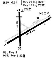
Runway Summary
| Runways: | 05/23 17/35 |
| Longest Runway: | 05/23 is 4494 ft (1370 m) long |
| Runways with an Instrument Approach: |
MKK Airport Runway Details
| Runway 05/23 | 4494 ft x 100 ft (1370 m x 30 m) | |
| Surface: | Asphalt - Good condition - Saw-cut or plastic grooved | |
| Runway Pavement Class: | 28 /F/A/W/T | |
| Runway Edge Lights: | Medium Intensity | |
Runway Weight Bearing Capacity (in thousands of pounds) |
||
| Single Wheel Landing Gear: | 30.0 | |
| Dual Wheel Landing Gear: | 48.0 | |
Runway 05 |
Runway 23 |
|
Elevation: |
437.1 | 453.9 |
Latitude: |
21-08-58.6840N | 21-09-20.6660N |
Longitude: |
157-06-03.8650W | 157-05-22.5790W |
|
Runway True Alignment: |
060 | 240 |
Glide Path Angle: |
4.0 degrees | 0.0 degrees |
Traffic Pattern: |
Left | Left |
Runway Markings Type: |
Nonprecision Instrument | Nonprecision Instrument |
Runway Markings Condition: |
Good | Good |
Object at End: |
BRUSH | |
Object Height: |
23 | |
Distance from End: |
400 | |
Object Centerline Offset: |
0 ft. left and right of centerline | |
Visual Glide Slope Indicators: |
4-Light PAPI On Left Side Of Runway | |
REIL: |
Yes | No |
Touchdown Lights: |
No | No |
Centerline Lights: |
No | No |
Threshold Crossing Height: |
49 | |
Threshold Elevation: |
445.2 | |
Displaced Threshold: |
593 | |
Threshold Latitude: |
21-09-17.7640N | |
Threshold Longitude: |
157-05-28.0310W | |
Declared Distances |
||
Take Off Run Avbl. (TORA): |
4494 | 4494 |
Take Off Distance Avbl. (TODA): |
4494 | 4494 |
Actual Stop Dist. Avbl. (ASDA): |
4494 | 4494 |
Landing Dist. Avbl. (LDA): |
4494 | 3901 |
| Runway 17/35 | 3118 ft x 100 ft (950 m x 30 m) | |
| Surface: | Asphalt - Good condition - No special surface treatment | |
| Runway Pavement Class: | 4 /F/B/W/T | |
| Runway Edge Lights: | Medium Intensity | |
Runway Weight Bearing Capacity (in thousands of pounds) |
||
| Single Wheel Landing Gear: | 13.0 | |
Runway 17 |
Runway 35 |
|
Elevation: |
448.4 | 430.3 |
Latitude: |
21-09-26.8680N | 21-08-55.9690N |
Longitude: |
157-05-51.2680W | 157-05-51.2860W |
|
Runway True Alignment: |
180 | 000 |
Glide Path Angle: |
0.0 degrees | 0.0 degrees |
Traffic Pattern: |
Left | Left |
Runway Markings Type: |
Basic | Basic |
Runway Markings Condition: |
Good | Good |
Object at End: |
FENCE | FENCE |
Object Height: |
12 | 4 |
Distance from End: |
80 | 248 |
Object Centerline Offset: |
0 ft. left and right of centerline | |
REIL: |
No | No |
Touchdown Lights: |
No | No |
Centerline Lights: |
No | No |
Threshold Elevation: |
442.5 | |
Displaced Threshold: |
426 | |
Threshold Latitude: |
21-09-22.6460N | |
Threshold Longitude: |
157-05-51.2700W | |
Declared Distances |
||
Take Off Run Avbl. (TORA): |
3118 | 3118 |
Take Off Distance Avbl. (TODA): |
3118 | 3118 |
Actual Stop Dist. Avbl. (ASDA): |
3118 | 3118 |
Landing Dist. Avbl. (LDA): |
2692 | 3118 |
Services
Airframe Repair: |
Major |
Powerplant Repair: |
Major |
Fuel Available: |
100, Jet A |
Landing Fees: |
No |
Parking: |
Tiedowns available |
Maps & Diagrams
MKK Sectional
Flight Planning
at skyvector.com
at skyvector.com