Location
Latitude: |
39-03-29.0230N (39.058062) |
Longitude: |
098-10-01.1900W (-98.166997) |
Elevation: |
1412.0 feet MSL (430 m MSL) |
Magnetic Variation: |
3.6 E (as of April 2024 from WMM2020 model) |
Time Zone: |
UTC -6.0 (Standard Time) UTC -5.0 (Daylight Savings Time) |
From City: |
02 N.M. NW of Lincoln, Kansas |
Found On: |
Wichita Chart |
FAA Region: |
ACE |
Contacts
Manager: |
Publicly owned: |
| CLAY HARING POST ROCK AVIATION, BOX 444 LINCOLN, KS 67455 785-524-5240 |
CITY OF LINCOLN 143 E LINCOLN LINCOLN, KS 67455 785-524-4280 |
Operations
Airport Status: |
Operational |
Facility Use: |
Public |
Type: |
Airport |
Activation Date: |
09/1948 |
Control tower: |
No |
Attendance (Months/Days/Hours): |
Months/Days/Hours MAR-NOV/MON-FRI/0800-1700 |
Boundary ARTCC: |
ZKC (Kansas City) |
Responsible ARTCC: |
ZKC (Kansas City) |
Lighting Schedule: |
SS-SR |
Segmented Circle Indicator: |
No |
Traffic Pattern Altitude (MSL): |
2412 feet (735 m) |
NOTAMs Facility: |
ICT |
NOTAM-D Service: |
Yes |
International Airport of Entry: |
No |
Customs Landing Rights: |
No |
Military Landing Rights: |
No |
Civil/Military Joint Use: |
No |
Based Aircraft
| Single Engine: | 6 |
Annual Operations (as of 09/18/2018)
| Total Operations: | 14300 | |
| GA Local: | 10000 | 69.9% |
| GA Itinerant: | 4000 | 28.0% |
| Military Aircraft: | 300 | 2.1% |
Communications
| CTAF: | 122.900 |
Fixed Based Operators (FBOs) & Fuel
(Click on a business for detail)
Please help us keep this information up to date. This is a FREE SERVICE just like everything else on Airport Guide! If you see that a business needs to be added, modified, or deleted please fill out our Update Form.
To add, modify, or delete a business click here.
Please help us keep this information up to date. This is a FREE SERVICE just like everything else on Airport Guide! If you see that a business needs to be added, modified, or deleted please fill out our Update Form.
Area Code: 785 |
| Business Name | Frequency | Phone | Fuel Grade |
|---|
Flight Service Stations
| Primary | Alternate | |
| FSS on Field: | N | |
| FSS Name (ID): | Wichita(ICT) | |
| Frequency: | ||
| Toll Free Phone: | 1-800-WX-BRIEF |
Instrument Procedures / Charts
Terminal Procedures are only available for airports in several countries with more being added all the time. If you are looking for a specific country's charts, please send an email to support(at)airportguide.com stating the country name. This will be used to prioritize the implementation.
Navigation Aids (Navaids) near K71
| Dist (NM) | ID | Morse Code | Name | Type | Freq | True Hdg | Mag Hdg |
|---|---|---|---|---|---|---|---|
| 26.7 | SLN | . . . . _ . . _ . | Salina | VORTAC | 117.10 | 107 | 104 |
| 33.2 | SL | . . . . _ . . | Flory | NDB | 344 | 132 | 129 |
| 38.2 | CNK | _ . _ . _ . _ . _ | Concordia | NDB | 335 | 38 | 35 |
| 42.8 | LYO | . _ . . _ . _ _ _ _ _ | Lyons | NDB | 386 | 183 | 179 |
| 45.1 | TKO | _ _ . _ _ _ _ | Mankato | VORTAC | 109.80 | 354 | 350 |
| 48.1 | MPR | _ _ . _ _ . . _ . | Mc Pherson | NDB | 227 | 152 | 149 |
| 50.6 | CYW | _ . _ . _ . _ _ . _ _ | Clay Center | NDB | 362 | 67 | 64 |
| 51.1 | RPB | . _ . . _ _ . _ . . . | Republican | NDB | 414 | 27 | 24 |
| 53.3 | HYS | . . . . _ . _ _ . . . | Hays | VORTAC | 110.40 | 256 | 252 |
| 53.5 | HY | . . . . _ . _ _ | Nette | NDB | 374 | 251 | 247 |
| 54.3 | HIL | . . . . . . . _ . . | Hilyn | NDB | 338 | 219 | 215 |
| 57.2 | HU | . . . . . . _ | Saltt | NDB | 404 | 168 | 165 |
| 58.2 | GB | _ _ . _ . . . | Babsy | NDB | 419 | 213 | 209 |
| 61.1 | FRI | . . _ . . _ . . . | Fort Riley | VOR | 109.40 | 94 | 91 |
| 64.0 | CVY | _ . _ . . . . _ _ . _ _ | Cavalry | NDB | 314 | 91 | 88 |
| 64.6 | HUT | . . . . . . _ _ | Hutchinson | VOR-DME | 116.80 | 170 | 167 |
| 64.9 | PHG | . _ _ . . . . . _ _ . | Phillipsburg | NDB | 368 | 307 | 303 |
| 67.0 | LQR | . _ . . _ _ . _ . _ . | Larned | NDB | 296 | 220 | 216 |
| 67.0 | HRU | . . . . . _ . . . _ | Herington | NDB | 407 | 108 | 105 |
| 68.9 | CA | _ . _ . . _ | Harvs | NDB | 395 | 142 | 139 |
Nearby Airports with Fuel
Notices to Airmen (NOTAMS)
Remarks
| A110-2 | ARPT MAY NOT BE ATNDD DURG PERIODS WHEN AGRICULTURAL ACTIVITIES ARE NOT CONDUCTED. |
| A110-3 | SLIGHT RODENT ACTVTY ON RYS 02/20 & 15/33. |
| A110-4 | FOR CD CTC KANSAS CITY ARTCC AT 913-254-8508. |
| A14 | POST ROCK AVIATION; CLAY HARING. |
| A33-02/20 | RODENT ACTVTY ON RY CLOSELY MONITORED BY MGMT. |
| A33-15/33 | RODENT ACTVTY ON RY CLOSELY MONITORED BY MGMT. |
| A52-02 | 30 FT TREE 335 FT FM RY END 69 FT L WITH OTHER TREES IN VICINITY. |
| A70-FUEL-10 | 0LL FOR FUEL AFTER HRS. CALL (785) 524-5240. |
| E111 | PREDATES ACT. |
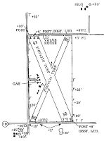
Runways
Runway Summary
| Runways: | 02/20 15/33 |
| Longest Runway: | 02/20 is 2700 ft (823 m) long |
| Runways with an Instrument Approach: |
K71 Airport Runway Details
| Runway 02/20 | 2700 ft x 130 ft (823 m x 40 m) | |
| Surface: | Turf - Good condition - No special surface treatment | |
| Runway Edge Lights: | Low Intensity | |
Runway 02 |
Runway 20 |
|
Glide Path Angle: |
0.0 degrees | 0.0 degrees |
Object at End: |
ROAD | TREE |
Object Height: |
21 | 32 |
Distance from End: |
75 | 730 |
Object Centerline Offset: |
0 ft. left and right of centerline | 0 ft. left and right of centerline |
| Runway 15/33 | 2700 ft x 370 ft (823 m x 113 m) | |
| Surface: | Turf - Good condition - No special surface treatment | |
| Runway Edge Lights: | Low Intensity | |
Runway 15 |
Runway 33 |
|
Glide Path Angle: |
0.0 degrees | 0.0 degrees |
Traffic Pattern: |
Left | Left |
Object at End: |
ROAD | ROAD |
Object Height: |
18 | 22 |
Distance from End: |
39 | 75 |
Object Centerline Offset: |
0 ft. left and right of centerline | 0 ft. left and right of centerline |
Services
Airframe Repair: |
None |
Powerplant Repair: |
None |
Bottled Oxygen: |
None |
Bulk Oxygen: |
None |
Fuel Available: |
100LL |
Landing Fees: |
No |
Parking: |
Hangars and tiedowns available |
Maps & Diagrams
K71 Sectional
Flight Planning
at skyvector.com
at skyvector.com