Location
Latitude: |
68-20-55.5800N (68.348772) |
Longitude: |
166-47-57.3400W (-166.799261) |
Elevation: |
20.7 feet MSL (6 m MSL) |
Magnetic Variation: |
6.8 E (as of May 2024 from WMM2020 model) |
Time Zone: |
UTC -9.0 (Standard Time) UTC -8.0 (Daylight Savings Time) |
From City: |
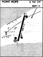
02 N.M. SW of Point Hope, Alaska |
Found On: |
Cape Lisburne Chart |
FAA Region: |
AAL |
Contacts
Manager: |
Publicly owned: |
| ALVIN WERNEKE PO BOX 55 KOTZEBUE, AK 99752 907-442-3147 |
ALASKA DOT&PF NORTHERN REGION 2301 PEGER ROAD FAIRBANKS, AK 99709 907-451-2200 |
Operations
Airport Status: |
Operational |
Facility Use: |
Public |
Type: |
Airport |
Activation Date: |
07/1958 |
Control tower: |
No |
Attendance (Months/Days/Hours): |
Months/Days/Hours Unattended |
Boundary ARTCC: |
ZAN (Anchorage) |
Responsible ARTCC: |
ZAN (Anchorage) |
Lighting Schedule: |
SEE RMK |
Segmented Circle Indicator: |
Yes |
Traffic Pattern Altitude (MSL): |
1021 feet (311 m) |
NOTAMs Facility: |
PHO |
NOTAM-D Service: |
Yes |
International Airport of Entry: |
No |
Customs Landing Rights: |
No |
Military Landing Rights: |
Yes |
Civil/Military Joint Use: |
No |
Based Aircraft
Annual Operations (as of 12/31/2020)
| Total Operations: | 1200 | |
| Air Taxi: | 1200 | 100.0% |
Communications
| CTAF: | 122.800 |
| AWOS-3P: | 118.325 (907-368-2128) |
- APCH/DEP SVC PRVDD BY ANCHORAGE ARTCC ON FREQS 119.65/363.25(CAPE LISBURNE RCAG).
- COMMUNICATIONS PRVDD BY KOTZEBUE FSS ON FREQ 122.25 (POINT HOPE RCO).
Fixed Based Operators (FBOs) & Fuel
(Click on a business for detail)
Please help us keep this information up to date. This is a FREE SERVICE just like everything else on Airport Guide! If you see that a business needs to be added, modified, or deleted please fill out our Update Form.
To add, modify, or delete a business click here.
Please help us keep this information up to date. This is a FREE SERVICE just like everything else on Airport Guide! If you see that a business needs to be added, modified, or deleted please fill out our Update Form.
Area Code: 907 |
| Business Name | Frequency | Phone | Fuel Grade |
|---|
Flight Service Stations
| Primary | Alternate | |
| FSS on Field: | N | |
| FSS Name (ID): | Kotzebue(OTZ) | Fairbanks (FAI) |
| Frequency: | ||
| Toll Free Phone: | 1-800-478-7460 | 1-866-248-6516 |
Instrument Procedures / Charts
FAA Terminal Procedures valid from 0901Z 05/16/24 to 0901Z 06/13/24.
There are various types of charts available for an airport. They are listed in the Page Type column. Here is a legend for those types:
APD - Airport Diagram
DP - Departure Procedure Charts
HOT - Hot Spots
IAP - Instrument Approach Procedure Charts
MIN - Minimums
STAR - Standard Terminal Arrival Charts
| Page Type | Page Name | Volume | Action Since Last Cycle |
|---|---|---|---|
| IAP | RNAV (GPS) RWY 01 | AK-1 | |
| IAP | RNAV (GPS) RWY 19 | AK-1 | |
| MIN | TAKEOFF MINIMUMS | AK-1 |
Terminal Procedures are only available for airports in several countries with more being added all the time. If you are looking for a specific country's charts, please send an email to support(at)airportguide.com stating the country name. This will be used to prioritize the implementation.
Navigation Aids (Navaids) near PHO
| Dist (NM) | ID | Morse Code | Name | Type | Freq | True Hdg | Mag Hdg |
|---|---|---|---|---|---|---|---|
| 0.3 | PHO | . _ _ . . . . . _ _ _ | Point Hope | NDB | 221 | 174 | 167 |
| 35.1 | LUR | . _ . . . . _ . _ . | Cape Lisburne | NDB-DME | 385 | 26 | 19 |
| 88.9 | DGG | _ . . _ _ . _ _ . | Red Dog | NDB-DME | 429 | 100 | 92 |
| 98.0 | OQK | _ _ _ _ _ . _ _ . _ | Noatak | NDB-DME | 414 | 116 | 108 |
Nearby Airports with Fuel
| Dist (NM) | Name (Airport IDs) | True Hdg | Mag Hdg | Fuel Grade |
|---|
Notices to Airmen (NOTAMS)
Remarks
| A110-2 | RY CONDITION NOT MONITORED; RECOMMEND VISUAL INSPECTION PRIOR TO LANDING. |
| A110-3 | (A70) FUEL AVBL EMERGENCY ONLY. |
| A110-4 | WX CAMERA AVBL ON INTERNET AT HTTPS://WEATHERCAMS.FAA.GOV |
| A33-01/19 | LATERAL CRACKS 1-3 INCHES ACROSS WIDTH OF RY SPACED 200-500 FT LEN OF RY. |
| A5 | NORTHWEST ARCTIC BOROUGH |
| A81-APT | ACTVT MIRL RY 01/19 - CTAF. |
Runways
Runway Summary
| Runways: | 01/19 |
| Longest Runway: | 01/19 is 3992 ft (1217 m) long |
| Runways with an Instrument Approach: |
PHO Airport Runway Details
| Runway 01/19 | 3992 ft x 75 ft (1217 m x 23 m) | |
| Runway Length Source: | 3RD PARTY SURVEY as of 08/06/2010 | |
| Surface: | Asphalt - Fair condition - No special surface treatment | |
| Runway Edge Lights: | Medium Intensity | |
Runway 01 |
Runway 19 |
|
Elevation: |
18.3 | 18.3 |
Latitude: |
68-20-37.4100N | 68-21-13.7500N |
Longitude: |
166-48-17.5000W | 166-47-37.1800W |
|
Runway True Alignment: |
022 | 202 |
Glide Path Angle: |
3.0 degrees | 3.0 degrees |
Traffic Pattern: |
Left | Left |
Runway Markings Type: |
Nonprecision Instrument | Nonprecision Instrument |
Runway Markings Condition: |
Good | Good |
Visual Glide Slope Indicators: |
4-Box VASI On Left Side Of Runway | 4-Box VASI On Left Side Of Runway |
Threshold Crossing Height: |
25 | 27 |
Services
Airframe Repair: |
None |
Powerplant Repair: |
None |
Bottled Oxygen: |
None |
Bulk Oxygen: |
None |
Landing Fees: |
No |
Parking: |
Tiedowns available |
Maps & Diagrams
PHO Sectional
Flight Planning
at skyvector.com
at skyvector.com