
Location
Latitude: |
43-39-30.2454N (43.658401) |
Longitude: |
007-12-57.1317E (7.21587) |
Elevation: |
12 feet MSL (4 m MSL) |
Magnetic Variation: |
3 E (as of April 2024 from WMM2020 model) |
Time Zone: |
UTC +1.0 (Standard Time) UTC +2.0 (Daylight Savings Time) |
Contacts
Manager: |
: |
Operations
Airport Status: |
Operational |
Facility Use: |
Public |
Type: |
Airport |
Traffic Pattern Altitude (MSL): |
1012 feet (308 m) |
Based Aircraft
Annual Operations (as of )
Communications
| NICE TWR: | 118.7 |
| NICE GND: | 121.775 |
| NICE APP: | 124.175 |
| NICE ATIS: | 129.6 |
Fixed Based Operators (FBOs) & Fuel
(Click on a business for detail)
Please help us keep this information up to date. This is a FREE SERVICE just like everything else on Airport Guide! If you see that a business needs to be added, modified, or deleted please fill out our Update Form.
To add, modify, or delete a business click here.
Please help us keep this information up to date. This is a FREE SERVICE just like everything else on Airport Guide! If you see that a business needs to be added, modified, or deleted please fill out our Update Form.
| Business Name | Frequency | Phone | Fuel Grade |
|---|---|---|---|
| Aviapartner
Website Update FBO info |
131.550 | 00 33 (0) 4 93 21 37 37 Mobile : 0033 (0)6 20 60 04 23 |
Flight Service Stations
| Primary | Alternate | |
| FSS on Field: | ||
| FSS Name (ID): | ||
| Frequency: | ||
| Toll Free Phone: |
Instrument Procedures / Charts
Terminal Procedures are only available for airports in several countries with more being added all the time. If you are looking for a specific country's charts, please send an email to support(at)airportguide.com stating the country name. This will be used to prioritize the implementation.
Navigation Aids (Navaids) near NCE
| Dist (NM) | ID | Morse Code | Name | Type | Freq | True Hdg | Mag Hdg |
|---|---|---|---|---|---|---|---|
| 0.4 | AZR | Nice Cote D Azur | VOR-DME | 109.65 | 78 | 75 | |
| 3.1 | CGS | Cagnes Sur Mer | VOR-DME | 109.20 | 255 | 252 | |
| 5.6 | NC | Nice/Cote D'Azur | NDB | 338 | 222 | 219 | |
| 6.3 | LEZ | Nice | NDB | 399 | 50 | 47 | |
| 6.9 | NIZ | Nice | VOR-DME | 112.40 | 13 | 10 | |
| 16.1 | CNM | Cannes | VOR | 111.40 | 248 | 245 | |
| 31.2 | MUS | Nice Cote D Azur | NDB | 428 | 238 | 235 | |
| 34.2 | LU | Le Luc | NDB | 378 | 241 | 238 | |
| 37.5 | STP | St.tTopez | VOR-DME | 116.50 | 225 | 222 | |
| 44.9 | LUC | Le Luc | VOR-DME | 113.00 | 248 | 245 | |
| 45.9 | ALB | Albenga | VOR-DME | 116.95 | 59 | 56 | |
| 49.6 | ABN | Albenga | NDB | 420 | 60 | 57 | |
| 52.2 | DGN | Digne | VOR | 113.85 | 292 | 289 | |
| 55.9 | LEV | Levaldigi | NDB | 371 | 17 | 14 | |
| 57.4 | HYE | Hyeres | TACAN | 109.00 | 234 | 231 | |
| 59.7 | TLN | Hyeres | NDB | 322 | 231 | 228 | |
| 72.3 | OB | Marseille/Provence | NDB | 395 | 249 | 246 | |
| 77.7 | SCL | Saint Christol | NDB | 348 | 288 | 285 | |
| 80.9 | TOP | Torino | NDB | 393 | 19 | 16 | |
| 80.9 | TOP | Torino | VOR-DME | 114.50 | 19 | 16 |
Nearby Airports with Fuel
| Dist (NM) | Name (Airport IDs) | True Hdg | Mag Hdg | Fuel Grade |
|---|
Notices to Airmen (NOTAMS)
Remarks
No remarks for this landing facility
Runways
Runway Summary
| Runways: | 04L/22R 04R/22L |
| Longest Runway: | 04R/22L is 9721 ft (2963 m) long |
| Runways with an Instrument Approach: |
NCE Airport Runway Details
| Runway 04L/22R | 8622 ft x 148 ft (2628 m x 45 m) | |
| Runway Edge Lights: | Yes Intensity | |
Runway 04L |
Runway 22R |
|
Elevation: |
11 | 10 |
Latitude: |
43.65179824829 | 43.66949844360 |
Longitude: |
7.2040400505065 | 7.2285099029541 |
|
Runway True Alignment: |
45 | 225 |
Glide Path Angle: |
0.0 degrees | 0.0 degrees |
REIL: |
Yes | Yes |
Threshold Elevation: |
11 | 10 |
Displaced Threshold: |
575 |
| Runway 04R/22L | 9721 ft x 148 ft (2963 m x 45 m) | |
| Runway Edge Lights: | Yes Intensity | |
Runway 04R |
Runway 22L |
|
Elevation: |
10 | 12 |
Latitude: |
43.64670181274 | 43.66559982299 |
Longitude: |
7.2024898529052 | 7.2284398078918 |
|
Runway True Alignment: |
45 | 225 |
Glide Path Angle: |
0.0 degrees | 0.0 degrees |
REIL: |
Yes | Yes |
Threshold Elevation: |
10 | 12 |
Services
Other Services: |
Ground Handling - Passenger Services, Ramp Services, Traffic Operations Cargo Services The FBO services we provide are: • Domestic & international handling • Fast turnarounds • Passenger & crew assistance • Airport & airway slot coordination • Flight planning & weather - NOTAMs • Traffic rights & landing permits • Aircraft charter reservation • Catering arrangements • Hotel & restaurant reservations • Limousine & car rental • Customs & immigration assistance • Change aircraft charter reservation (by aircraft & helicopter charter) • Fueling and fueling arrangements |
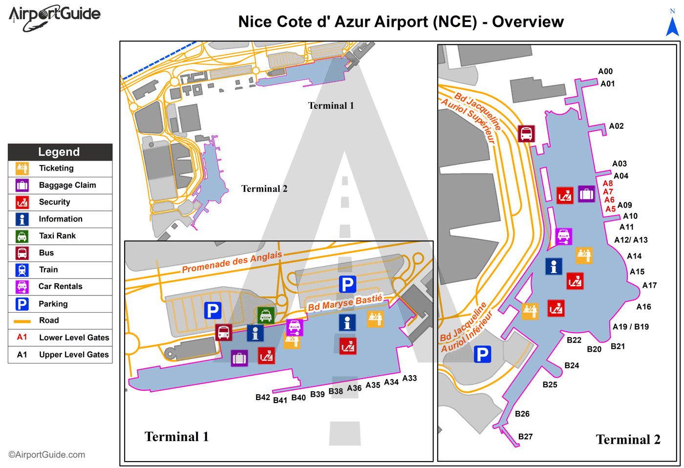
Maps & Diagrams
NCE Sectional
Flight Planning
at skyvector.com
at skyvector.com
