Location
Latitude: |
63-52-03.3000N (63.867583) |
Longitude: |
148-58-07.8000W (-148.968833) |
Elevation: |
1275.0 feet MSL (389 m MSL) |
Magnetic Variation: |
15.2 E (as of April 2024 from WMM2020 model) |
Time Zone: |
UTC -9.0 (Standard Time) UTC -8.0 (Daylight Savings Time) |
From City: |
00 N.M. N of Healy, Alaska |
Found On: |
Anchorage Chart |
FAA Region: |
AAL |
Contacts
Manager: |
Publicly owned: |
| JASON LUDINGTON 2301 PEGER ROAD FAIRBANKS, AK 99709 907-451-5280 |
ALASKA DOT&PF NORTHERN REGION 2301 PEGER ROAD FAIRBANKS, AK 99709 907-451-2200 |
Operations
Airport Status: |
Operational |
Facility Use: |
Public |
Type: |
Airport |
Activation Date: |
10/1950 |
Control tower: |
No |
Attendance (Months/Days/Hours): |
Months/Days/Hours Unattended |
Boundary ARTCC: |
ZAN (Anchorage) |
Responsible ARTCC: |
ZAN (Anchorage) |
Lighting Schedule: |
SEE RMK |
Segmented Circle Indicator: |
Yes |
Traffic Pattern Altitude (MSL): |
2275 feet (693 m) |
NOTAMs Facility: |
FAI |
NOTAM-D Service: |
Yes |
International Airport of Entry: |
No |
Customs Landing Rights: |
No |
Military Landing Rights: |
Yes |
Civil/Military Joint Use: |
No |
Based Aircraft
| Single Engine: | 7 |
| Multi Engine: | 2 |
Annual Operations (as of 12/31/2019)
| Total Operations: | 1300 | |
| Air Taxi: | 500 | 38.5% |
| GA Local: | 300 | 23.1% |
| GA Itinerant: | 500 | 38.5% |
Communications
| CTAF: | 122.900 |
- APCH/DEP SVC PRVDD BY ANCHORAGE ARTCC (ZAN) ON 120.9/319.2 (MURPHY DOME RCAG).
Fixed Based Operators (FBOs) & Fuel
(Click on a business for detail)
Please help us keep this information up to date. This is a FREE SERVICE just like everything else on Airport Guide! If you see that a business needs to be added, modified, or deleted please fill out our Update Form.
To add, modify, or delete a business click here.
Please help us keep this information up to date. This is a FREE SERVICE just like everything else on Airport Guide! If you see that a business needs to be added, modified, or deleted please fill out our Update Form.
Area Code: 907 |
| Business Name | Frequency | Phone | Fuel Grade |
|---|
Flight Service Stations
| Primary | Alternate | |
| FSS on Field: | N | |
| FSS Name (ID): | Fairbanks(FAI) | |
| Frequency: | ||
| Toll Free Phone: | 1-866-248-6516 |
Instrument Procedures / Charts
FAA Terminal Procedures valid from 0901Z 03/21/24 to 0901Z 04/18/24.
There are various types of charts available for an airport. They are listed in the Page Type column. Here is a legend for those types:
APD - Airport Diagram
DP - Departure Procedure Charts
HOT - Hot Spots
IAP - Instrument Approach Procedure Charts
MIN - Minimums
STAR - Standard Terminal Arrival Charts
| Page Type | Page Name | Volume | Action Since Last Cycle |
|---|---|---|---|
| IAP | RNAV (GPS) RWY 15 | AK-1 | Changed |
| IAP | RNAV (GPS)-A | AK-1 | |
| MIN | TAKEOFF MINIMUMS | AK-1 | |
| ODP | HEALY TWO (OBSTACLE) (RNAV) | AK-1 |
Terminal Procedures are only available for airports in several countries with more being added all the time. If you are looking for a specific country's charts, please send an email to support(at)airportguide.com stating the country name. This will be used to prioritize the implementation.
Navigation Aids (Navaids) near HKB
| Dist (NM) | ID | Morse Code | Name | Type | Freq | True Hdg | Mag Hdg |
|---|---|---|---|---|---|---|---|
| 33.7 | UMM | . . _ _ _ _ _ | Summit | NDB | 326 | 187 | 172 |
| 40.8 | ICW | . . _ . _ . . _ _ | Ice Pool | NDB | 525 | 356 | 341 |
| 43.4 | ENN | . _ . _ . | Nenana | VORTAC | 115.80 | 356 | 341 |
| 61.2 | FAI | . . _ . . _ . . | Fairbanks | VORTAC | 108.60 | 23 | 8 |
| 67.9 | EIL | . . . . _ . . | Eielson | TACAN | 115.10 | 45 | 29 |
| 69.7 | CUN | _ . _ . . . _ _ . | Chena | NDB | 257 | 32 | 17 |
| 75.2 | FOX | . . _ . _ _ _ _ . . _ | Fox | NDB | 356 | 27 | 12 |
| 86.1 | BIG | _ . . . . . _ _ . | Big Delta | VORTAC | 114.90 | 83 | 67 |
| 87.0 | DJN | _ . . . _ _ _ _ . | Delta Junction | NDB | 347 | 82 | 66 |
| 88.4 | MHM | _ _ . . . . _ _ | Minchumina | NDB | 227 | 272 | 257 |
| 97.1 | PEE | . _ _ . . . | Peters Creek | NDB | 305 | 198 | 183 |
| 99.1 | TKA | _ _ . _ . _ | Talkeetna | VOR-DME | 116.20 | 198 | 183 |
Nearby Airports with Fuel
| Dist (NM) | Name (Airport IDs) | True Hdg | Mag Hdg | Fuel Grade |
|---|---|---|---|---|
| 28.6 | Cantwell Airport (PATW TTW) |
179 | 164 | 100LL |
| 40.9 | Nenana Municipal Airport (ENN PANN ENN) |
356 | 341 | 100LL, Jet A |
| 63.8 | Fairbanks International Airport (FAI PAFA FAI) |
26 | 10 | 100LL, Jet A-1 |
| 67.5 | Bradley Sky-Ranch Airport (95Z) |
36 | 20 | 100LL |
| 97.7 | Talkeetna Airport (TKA PATK TKA) |
198 | 183 | 100LL, Jet A, Jet A+ |
Notices to Airmen (NOTAMS)
Remarks
| A110-1 | TURBULENT WINDS INVOF ARPT. |
| A110-3 | RWY CONDITION NOT MONITORED; RECOMMEND VISUAL INSPECTION PRIOR TO LANDING. |
| A110-4 | ARPT 2 SM SW OF USIBELLI MINE. |
| A110-5 | RR TRACKS 700 FT FM THLD 20 FT ABOVE RWY ELEVATION. |
| A110-6 | COLD TEMPERATURE AIRPORT. ALTITUDE CORRECTION REQUIRED AT OR BELOW -11C. |
| A33-15/33 | NUMEROUS CRACKS IN ASPH WITH WEEDS & GRASS GROWING THRU SFC UP TO 12 IN TALL. |
| A42-15 | RY 15/33 NSTD MKGS: THLD MKD BY PANELS, CONES & LIGHTS. |
| A70-FUEL-A | FULL SERVICE AV GAS AND JET A AVAILABLE DURING NORMAL BUSINESS HOURS MAY TO SEPTEMBER AND BY CALL OUT YEAR ROUND AND AFTER HOURS. CALL OUT FEE MAY APPLY, CALL: 907-683-2359. |
| A81-APT | ACTVT MIRL RY 15/33 - CTAF. |
| A84 | SEGMENTED CIRCLE 400 FT FM RY33 THLD 200 FT L OF CNTRLN. |
Runways
Runway Summary
| Runways: | 15/33 |
| Longest Runway: | 15/33 is 2910 ft (887 m) long |
| Runways with an Instrument Approach: |
HKB Airport Runway Details
| Runway 15/33 | 2910 ft x 60 ft (887 m x 18 m) | |
| Runway Length Source: | 3RD PARTY SURVEY as of 06/16/2013 | |
| Surface: | Asphalt - Good condition - No special surface treatment | |
| Runway Edge Lights: | Medium Intensity | |
Runway 15 |
Runway 33 |
|
Elevation: |
1256.4 | 1275.0 |
Latitude: |
63-52-17.4653N | 63-51-49.0939N |
Longitude: |
148-58-12.2416W | 148-58-03.3932W |
Glide Path Angle: |
0.0 degrees | 0.0 degrees |
Traffic Pattern: |
Right | Left |
Runway Markings Type: |
Nonstandard (other than numbers only) | Nonstandard (other than numbers only) |
Runway Markings Condition: |
Good | Good |
Object at End: |
TREES | TREES |
Object Height: |
25 | 8 |
Distance from End: |
200 | 200 |
Object Centerline Offset: |
75 ft. left of centerline | 115 ft. right of centerline |
Services
Airframe Repair: |
Major |
Powerplant Repair: |
Major |
Bottled Oxygen: |
None |
Bulk Oxygen: |
None |
Fuel Available: |
100LL, Jet A, Jet A+ |
Landing Fees: |
No |
Parking: |
Tiedowns available |
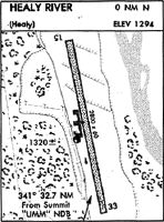
Maps & Diagrams
HKB Sectional
Flight Planning
at skyvector.com
at skyvector.com