
Location
Latitude: |
22-48-35.9981S (-22.809999) |
Longitude: |
043-15-02.005W (-43.250557) |
Elevation: |
28 feet MSL (9 m MSL) |
Magnetic Variation: |
23.1 W (as of May 2024 from WMM2020 model) |
Time Zone: |
UTC -3.0 (Standard Time) UTC -2.0 (Daylight Savings Time) |
Contacts
Manager: |
: |
Operations
Airport Status: |
Operational |
Facility Use: |
Public |
Type: |
Airport |
Traffic Pattern Altitude (MSL): |
1028 feet (313 m) |
Based Aircraft
Annual Operations (as of )
Communications
| TWR: | 118 |
| CLNC DEL: | 121 |
| GND: | 121.65 |
| RIO APP: | 119.35 |
| ATIS: | 127.6 |
| OPS: | 122.5 |
Fixed Based Operators (FBOs) & Fuel
(Click on a business for detail)
Please help us keep this information up to date. This is a FREE SERVICE just like everything else on Airport Guide! If you see that a business needs to be added, modified, or deleted please fill out our Update Form.
To add, modify, or delete a business click here.
Please help us keep this information up to date. This is a FREE SERVICE just like everything else on Airport Guide! If you see that a business needs to be added, modified, or deleted please fill out our Update Form.
| Business Name | Frequency | Phone | Fuel Grade |
|---|
Flight Service Stations
| Primary | Alternate | |
| FSS on Field: | ||
| FSS Name (ID): | ||
| Frequency: | ||
| Toll Free Phone: |
Instrument Procedures / Charts
Terminal Procedures are only available for airports in several countries with more being added all the time. If you are looking for a specific country's charts, please send an email to support(at)airportguide.com stating the country name. This will be used to prioritize the implementation.
Navigation Aids (Navaids) near GIG
| Dist (NM) | ID | Morse Code | Name | Type | Freq | True Hdg | Mag Hdg |
|---|---|---|---|---|---|---|---|
| 4.8 | YLA | Ilha | NDB | 330 | 73 | 96 | |
| 5.0 | CAX | Caxias | VOR-DME | 113.00 | 293 | 316 | |
| 5.6 | CAX | Caxias | NDB | 400 | 300 | 323 | |
| 5.9 | PP | Paiol | NDB | 415 | 127 | 150 | |
| 6.3 | IT | Meriti | NDB | 290 | 259 | 282 | |
| 7.3 | AFS | Afonsos | NDB | 270 | 241 | 264 | |
| 12.5 | JPG | Jacarepagua | NDB | 205 | 211 | 234 | |
| 13.9 | NOA | Nova | NDB | 215 | 293 | 316 | |
| 16.3 | IH | Rasa | NDB | 315 | 159 | 182 | |
| 22.0 | MRC | Marica | VOR-DME | 114.00 | 115 | 138 | |
| 22.5 | PCX | Porto | VOR-DME | 114.60 | 75 | 98 | |
| 23.1 | Cruz | NDB | 245 | 267 | 290 | ||
| 27.0 | SCR | Santa Cruz | NDB | 255 | 252 | 275 | |
| 27.7 | SCR | Santa Cruz | VOR-DME | 113.60 | 252 | 275 | |
| 39.0 | PAI | Pirai | NDB | 355 | 302 | 325 | |
| 39.0 | PAI | Pirai | VOR-DME | 115.00 | 303 | 326 | |
| 63.0 | FRA | Fora | NDB | 173 | 353 | 376 | |
| 63.8 | ADA | Aldeia | NDB | 345 | 90 | 113 | |
| 63.9 | ADA | Aldeia | VOR-DME | 112.10 | 90 | 113 | |
| 65.2 | CBF | Cabo Frio | NDB | 515 | 96 | 119 |
Nearby Airports with Fuel
| Dist (NM) | Name (Airport IDs) | True Hdg | Mag Hdg | Fuel Grade |
|---|
Notices to Airmen (NOTAMS)
Remarks
No remarks for this landing facility
Runways
Runway Summary
| Runways: | 10/28 15/33 |
| Longest Runway: | 10/28 is 13123 ft (4000 m) long |
| Runways with an Instrument Approach: |
GIG Airport Runway Details
| Runway 10/28 | 13123 ft x 148 ft (4000 m x 45 m) | |
| Runway Edge Lights: | Yes Intensity | |
Runway 10 |
Runway 28 |
|
Elevation: |
16 | 28 |
Latitude: |
-22.8018 | -22.7922 |
Longitude: |
-43.255199 | -43.217701 |
|
Runway True Alignment: |
74 | 254 |
Glide Path Angle: |
0.0 degrees | 0.0 degrees |
REIL: |
Yes | Yes |
Threshold Elevation: |
16 | 28 |
| Runway 15/33 | 10433 ft x 154 ft (3180 m x 47 m) | |
| Runway Edge Lights: | Yes Intensity | |
Runway 15 |
Runway 33 |
|
Elevation: |
16 | 11 |
Latitude: |
-22.812401 | -22.8291 |
Longitude: |
-43.263699 | -43.238499 |
|
Runway True Alignment: |
125 | 305 |
Glide Path Angle: |
0.0 degrees | 0.0 degrees |
REIL: |
Yes | Yes |
Threshold Elevation: |
16 | 11 |
Services
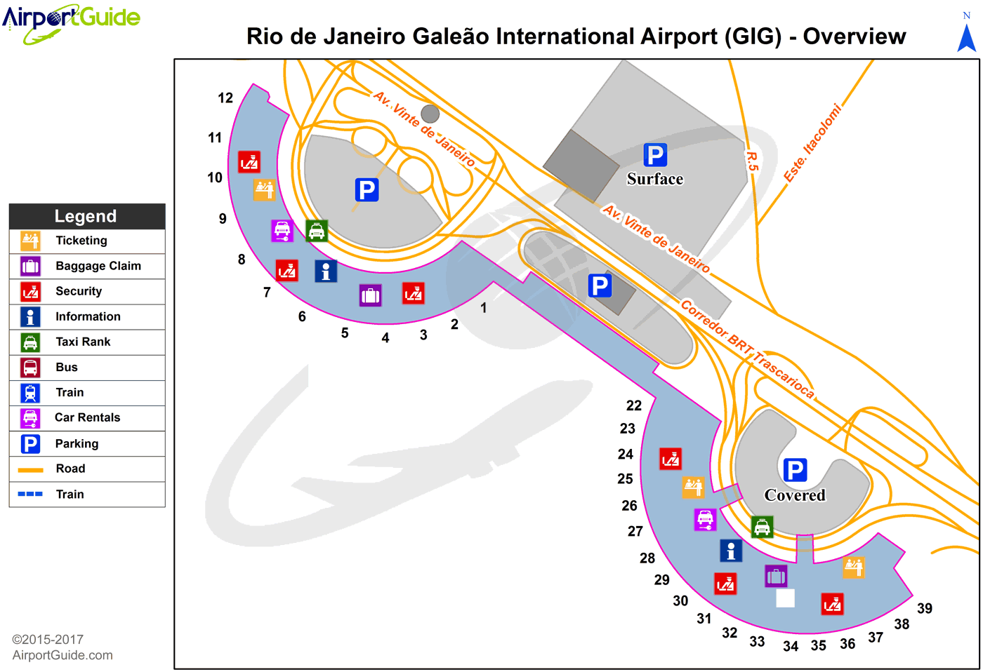
Maps & Diagrams
GIG Sectional
Flight Planning
at skyvector.com
at skyvector.com
