
Location
Latitude: |
18-20-14.3000N (18.337306) |
Longitude: |
064-58-24.0000W (-64.973333) |
Elevation: |
23.6 feet MSL (7 m MSL) |
Magnetic Variation: |
13.9 W (as of April 2024 from WMM2020 model) |
Time Zone: |
UTC -4.0 (Standard Time) UTC -4.0 (Daylight Savings Time) |
From City: |
02 N.M. W of Charlotte Amalie, Virgin Islands |
Found On: |
Puerto Rico-Virgin Islands Chart |
FAA Region: |
ASO |
Contacts
Manager: |
Publicly owned: |
| JEROME SHERIDAN CYRIL E. KING AIRPORT, P.O. BOX 301707 ST THOMAS, VI 00802 (340) 714-6667 |
V I PORT AUTHORITY 8074 LINDBERGH BAY, P.O. BOX 301707 ST THOMAS, VI 00803 340-774-1629 |
Operations
Airport Status: |
Operational |
Facility Use: |
Public |
Type: |
Airport |
Activation Date: |
09/1948 |
Control tower: |
Yes |
Attendance (Months/Days/Hours): |
Months/Days/Hours ALL/ALL/0700-2300 |
Boundary ARTCC: |
ZSU (San Juan) |
Responsible ARTCC: |
ZSU (San Juan) |
Lighting Schedule: |
SEE RMK |
Segmented Circle Indicator: |
Yes |
Traffic Pattern Altitude (MSL): |
1024 feet (312 m) |
NOTAMs Facility: |
TIST |
NOTAM-D Service: |
Yes |
International Airport of Entry: |
No |
Customs Landing Rights: |
Yes |
Military Landing Rights: |
Yes |
Civil/Military Joint Use: |
No |
Aircraft Rescue and Firefighting: |
Class I ARFF Index: C Air Carrier Service: Scheduled Certification Date: 05/1973 |
Based Aircraft
| Single Engine: | 25 |
| Multi Engine: | 44 |
| Jet Engine: | 4 |
| GA Helicopters: | 3 |
| Military Aircraft: | 1 |
| Ultralights: | 1 |
Annual Operations (as of 03/31/2019)
| Total Operations: | 20022 | |
| Commercial: | 2920 | 14.6% |
| Air Taxi: | 8445 | 42.2% |
| GA Local: | 7053 | 35.2% |
| GA Itinerant: | 1372 | 6.9% |
| Military Aircraft: | 232 | 1.2% |
Communications
| CTAF: | 118.800 |
| Unicom: | 122.950 |
| Tower: | SAINT THOMAS 118.1 ;NORTH OF ISLAND 118.8 257.6 Hrs: 0700-2230, ATCT CLOSES 1 HR EARLIER DRG DALGT SAVINGS TIME. |
| Ground: | 121.9 |
| Approach: | SAN JUAN CERAP |
| Departure: | SAN JUAN CERAP |
| ATIS: | 124.0 Hrs: 24 |
| ASOS: | 124.0 (340-776-7116) |
| EMERG: | 121.5 |
| EMERG: | 243.0 |
- APCH/DEP CLASS C SVC PRVDD BY SAN JUAN CERAP ON FREQS 128.65/279.6 (PICO DEL ESTE RCAG & EL YUNQUE RCAG).
Fixed Based Operators (FBOs) & Fuel
(Click on a business for detail)
Please help us keep this information up to date. This is a FREE SERVICE just like everything else on Airport Guide! If you see that a business needs to be added, modified, or deleted please fill out our Update Form.
To add, modify, or delete a business click here.
Please help us keep this information up to date. This is a FREE SERVICE just like everything else on Airport Guide! If you see that a business needs to be added, modified, or deleted please fill out our Update Form.
Area Code: 809 |
| Business Name | Frequency | Phone | Fuel Grade |
|---|---|---|---|
| Air St. Thomas
Update FBO info |
Unicom 123.25 | 776-2722 | |
| Bohlke International Airways
Update FBO info |
Unicom 123.0 | 777-9177 | 100LL, Jet A |
| Esso Virgin Islands, Inc.
Update FBO info |
774-6044 | 100LL, Jet A |
Flight Service Stations
| Primary | Alternate | |
| FSS on Field: | N | |
| FSS Name (ID): | San Juan(SJU) | |
| Frequency: | ||
| Toll Free Phone: | 1-800-WX-BRIEF |
Instrument Procedures / Charts
FAA Terminal Procedures valid from 0901Z 03/21/24 to 0901Z 04/18/24.
There are various types of charts available for an airport. They are listed in the Page Type column. Here is a legend for those types:
APD - Airport Diagram
DP - Departure Procedure Charts
HOT - Hot Spots
IAP - Instrument Approach Procedure Charts
MIN - Minimums
STAR - Standard Terminal Arrival Charts
| Page Type | Page Name | Volume | Action Since Last Cycle |
|---|---|---|---|
| APD | AIRPORT DIAGRAM | SE-3 | |
| DP | PALCO SEVEN | SE-3 | Changed |
| IAP | ILS OR LOC RWY 10 | SE-3 | Changed |
| IAP | RNAV (GPS) RWY 10 | SE-3 | Changed |
| IAP | VOR-A | SE-3 | Changed |
| MIN | ALTERNATE MINIMUMS | SE-3 | |
| MIN | TAKEOFF MINIMUMS | SE-3 |
Terminal Procedures are only available for airports in several countries with more being added all the time. If you are looking for a specific country's charts, please send an email to support(at)airportguide.com stating the country name. This will be used to prioritize the implementation.
Navigation Aids (Navaids) near STT
| Dist (NM) | ID | Morse Code | Name | Type | Freq | True Hdg | Mag Hdg |
|---|---|---|---|---|---|---|---|
| 3.1 | STT | . . . _ _ | St Thomas | VOR-DME | 108.60 | 290 | 304 |
| 25.7 | BFI | Beef Island | NDB | 360 | 75 | 89 | |
| 38.7 | NRR | _ . . _ . . _ . | Roosevelt Roads | TACAN | 113.80 | 261 | 275 |
| 39.1 | ST | . . . _ | Peste | NDB | 241 | 172 | 186 |
| 39.1 | SX | Peste | NDB | 241 | 172 | 186 | |
| 39.4 | COY | _ . _ . _ _ _ _ . _ _ | St Croix | VOR-DME | 108.20 | 156 | 170 |
| 58.2 | SJU | . . . . _ _ _ . . _ | San Juan | VORTAC | 114.00 | 276 | 290 |
| 63.7 | SJ | . . . . _ _ _ | Patty | NDB | 330 | 274 | 288 |
| 82.3 | DDP | _ . . _ . . . _ _ . | Dorado | NDB | 391 | 275 | 289 |
| 90.5 | PSE | . _ _ . . . . . | Ponce | DME | 257 | 271 |
Nearby Airports with Fuel
| Dist (NM) | Name (Airport IDs) | True Hdg | Mag Hdg | Fuel Grade |
|---|---|---|---|---|
| 38.6 | Jose Aponte De La Torre Airport (TJRV RVR) |
261 | 275 | 100LL, Jet A |
| 39.4 | Henry E Rohlsen Airport (STX TISX STX) |
165 | 179 | 100LL, Jet A-1+ |
| 58.9 | Luis Munoz Marin International Airport (SJU TJSJ SJU) |
276 | 290 | 100, Jet A+, Jet A++ |
| 64.5 | Fernando Luis Ribas Dominicci Airport (SIG TJIG SIG) |
276 | 290 | 100, Jet A |
Notices to Airmen (NOTAMS)
Remarks
| A110-1 | ACFT THAT BACK TAXI FOR DEP ON RY 28 SHALL MAKE THEIR 180 DEG TURN CCLKWS. |
| A110-10 | RY 10 DEPS MAINTAIN RY HDG UNTIL REACHING DEP END OF RY BFR TURNING ON COURSE OR ASSIGNED HDG UNLESS OTRW AUZD BY ATCT. |
| A110-11 | ARFF UNAVBL 2300-0630. |
| A110-12 | PILOTS CTC GND CTL PRIOR TO PUSHBACK. |
| A110-13 | OBSTRUCTION SAILBOAT MAST 100FT WEST OF APPROACH END OF RWY 10 50FT AGL |
| A110-14 | WHEN TWR CLSD CTC SAN JUAN CERAP AT 787-253-8664/8665 |
| A110-2 | NOISE SENSITIVE AREA: AVOID OVERFLIGHTS OF WATER ISLAND LOCATED 2 MI SE OF ARPT. |
| A110-5 | PILOTS MAY ENCTR FALSE ILLUSORY INDICATIONS DURG NGT VISUAL APCHS TO RY 10 WHEN USING VISUAL CUES FOR VERTICAL GUIDANCE; RCMD USE OF THE ILS GS & FQT CROSS REF WITH THE ACFT ALTM TO MAINT THE PROPER APCH PROFILE. |
| A110-7 | LGTS ON HILL 4 NM SE OF ARPT MAY BE MISTAKEN FOR RY 10/28 WHEN MAKING A VISUAL APCH FROM THE SOUTH. |
| A26 | CLSD TO UNSKED ACR OPNS WITH MORE THAN 30 PSGR SEATS EXCP 24 HRS PPR CALL AMGR 340-774-5100. |
| A52-10 | 50 FT SAILBOAT MAST 100 FT WEST OF APCH END OF RWY 10. |
| A70-FUEL-10 | 0LL FUEL AVBL 0700-1900, OTHER TIMES PPR CALL 340-777-9177, 340-772-8093, 340-715-3821 |
| A81-APT | HIRL RWY 10/28 OPER DUSK-2300. AFTER 2300, ACTVT HIRL RWY 10/28 - CTAF. |
Runways
Runway Summary
| Runways: | 10/28 |
| Longest Runway: | 10/28 is 7000 ft (2134 m) long |
| Runways with an Instrument Approach: | 10 |
STT Airport Runway Details
| Runway 10/28 | 7000 ft x 150 ft (2134 m x 46 m) | |
| Runway Length Source: | 3RD PARTY SURVEY as of 06/04/2012 | |
| Surface: | Asphalt - Fair condition - Saw-cut or plastic grooved | |
| Runway Pavement Class: | 88 /F/A/W/T | |
| Runway Edge Lights: | High Intensity | |
Runway Weight Bearing Capacity (in thousands of pounds) |
||
| Single Wheel Landing Gear: | 100.0 | |
| Dual Wheel Landing Gear: | 155.0 | |
| Dual Tandem Wheel Landing Gear: | 195.0 | |
Runway 10 |
Runway 28 |
|
Elevation: |
23.5 | 11.7 |
Latitude: |
18-20-12.7247N | 18-20-15.8124N |
Longitude: |
064-59-00.3371W | 064-57-47.7382W |
|
Runway True Alignment: |
087 | 267 |
ILS Type: |
ILS/DME | |
Glide Path Angle: |
3.0 degrees | 0.0 degrees |
Traffic Pattern: |
Right | Left |
Runway Markings Type: |
Precision Instrument | Basic |
Runway Markings Condition: |
Good | Good |
Object at End: |
POLE | POLE |
Object Height: |
28 | |
Distance from End: |
300 | |
Object Centerline Offset: |
400 ft. left of centerline | |
Visual Glide Slope Indicators: |
4-Light PAPI On Left Side Of Runway | |
REIL: |
No | |
Threshold Crossing Height: |
71 | |
Threshold Elevation: |
11.8 | |
Displaced Threshold: |
2300 | |
Threshold Latitude: |
18-20-14.7987N | |
Threshold Longitude: |
064-58-11.5902W | |
Declared Distances |
||
Take Off Run Avbl. (TORA): |
7000 | 7000 |
Take Off Distance Avbl. (TODA): |
7000 | 7000 |
Actual Stop Dist. Avbl. (ASDA): |
6892 | 6170 |
Landing Dist. Avbl. (LDA): |
6892 | 3870 |
Services
Airframe Repair: |
Major |
Powerplant Repair: |
Major |
Bottled Oxygen: |
High Pressure / Low Pressure |
Bulk Oxygen: |
None |
Fuel Available: |
100, Jet A |
Landing Fees: |
Yes |
Parking: |
Tiedowns available |
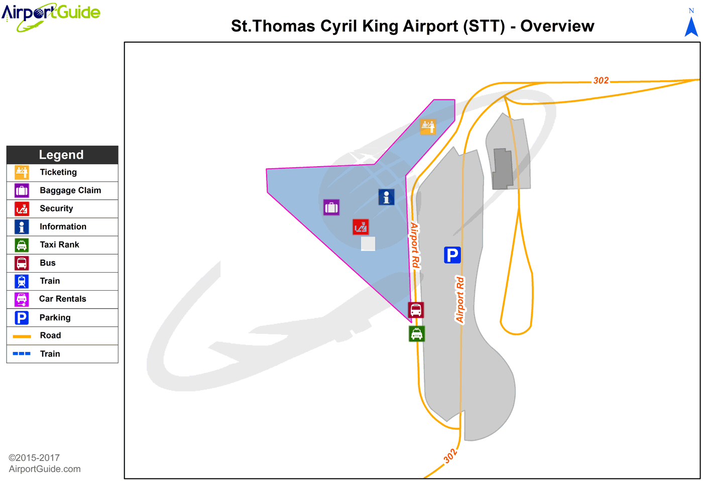
Maps & Diagrams
STT Sectional
Flight Planning
at skyvector.com
at skyvector.com
 Diagram")