Location
Latitude: |
48-36-30.0771N (48.608355) |
Longitude: |
112-22-34.1428W (-112.376151) |
Elevation: |
3857.8 feet MSL (1176 m MSL) |
Magnetic Variation: |
12.4 E (as of April 2024 from WMM2020 model) |
Time Zone: |
UTC -7.0 (Standard Time) UTC -6.0 (Daylight Savings Time) |
From City: |
03 N.M. SW of Cut Bank, Montana |
Found On: |
Great Falls Chart |
FAA Region: |
ANM |
Contacts
Manager: |
Publicly owned: |
| RON HERMANET P.O. BOX 130 CUT BANK, MT 59427 406-873-8683 |
CITY OF CUT BANK AND GLACIER COUNTY P.O. BOX 130 CUT BANK, MT 59427 406-873-8683 |
Operations
Airport Status: |
Operational |
Facility Use: |
Public |
Type: |
Airport |
Activation Date: |
09/1941 |
Control tower: |
No |
Attendance (Months/Days/Hours): |
Months/Days/Hours ALL/ALL/0830-1730 |
Boundary ARTCC: |
ZLC (Salt Lake City) |
Responsible ARTCC: |
ZLC (Salt Lake City) |
Lighting Schedule: |
SEE RMK |
Segmented Circle Indicator: |
Yes |
Traffic Pattern Altitude (MSL): |
4858 feet (1481 m) |
NOTAMs Facility: |
CTB |
NOTAM-D Service: |
Yes |
International Airport of Entry: |
Yes |
Customs Landing Rights: |
No |
Military Landing Rights: |
Yes |
Civil/Military Joint Use: |
No |
Based Aircraft
| Single Engine: | 17 |
| Multi Engine: | 1 |
Annual Operations (as of 07/27/2023)
| Total Operations: | 8250 | |
| Air Taxi: | 500 | 6.1% |
| GA Local: | 5000 | 60.6% |
| GA Itinerant: | 2600 | 31.5% |
| Military Aircraft: | 150 | 1.8% |
Communications
| CTAF: | 123.000 |
| Unicom: | 123.000 |
| ASOS: | 119.025 (406-873-2939) |
- APCH/DEP CTL SVC PRVDD BY SALT LAKE CITY ARTCC ( ZLC) ON FREQS 133.4/285.4 (GREAT FALLS RCAG).
Fixed Based Operators (FBOs) & Fuel
(Click on a business for detail)
Please help us keep this information up to date. This is a FREE SERVICE just like everything else on Airport Guide! If you see that a business needs to be added, modified, or deleted please fill out our Update Form.
To add, modify, or delete a business click here.
Please help us keep this information up to date. This is a FREE SERVICE just like everything else on Airport Guide! If you see that a business needs to be added, modified, or deleted please fill out our Update Form.
Area Code: 406 |
| Business Name | Frequency | Phone | Fuel Grade |
|---|---|---|---|
| Airport Management
Update FBO info |
Unicom 122.8 | 873-8683 | 100ll Jet A |
Flight Service Stations
| Primary | Alternate | |
| FSS on Field: | N | |
| FSS Name (ID): | Great Falls(GTF) | |
| Frequency: | ||
| Toll Free Phone: | 1-800-WX-BRIEF |
Instrument Procedures / Charts
FAA Terminal Procedures valid from 0901Z 03/21/24 to 0901Z 04/18/24.
There are various types of charts available for an airport. They are listed in the Page Type column. Here is a legend for those types:
APD - Airport Diagram
DP - Departure Procedure Charts
HOT - Hot Spots
IAP - Instrument Approach Procedure Charts
MIN - Minimums
STAR - Standard Terminal Arrival Charts
| Page Type | Page Name | Volume | Action Since Last Cycle |
|---|---|---|---|
| DP | MRIAS THREE (RNAV) | NW-1 | |
| IAP | RNAV (GPS) RWY 05 | NW-1 | |
| IAP | RNAV (GPS) RWY 14 | NW-1 | |
| IAP | RNAV (GPS) RWY 23 | NW-1 | |
| IAP | RNAV (GPS) RWY 32 | NW-1 | |
| IAP | VOR RWY 32 | NW-1 | |
| MIN | ALTERNATE MINIMUMS | NW-1 | |
| MIN | TAKEOFF MINIMUMS | NW-1 |
Terminal Procedures are only available for airports in several countries with more being added all the time. If you are looking for a specific country's charts, please send an email to support(at)airportguide.com stating the country name. This will be used to prioritize the implementation.
Navigation Aids (Navaids) near CTB
| Dist (NM) | ID | Morse Code | Name | Type | Freq | True Hdg | Mag Hdg |
|---|---|---|---|---|---|---|---|
| 2.9 | CTB | _ . _ . _ _ . . . | Cut Bank | VOR-DME | 113.35 | 153 | 141 |
| 20.8 | SBX | . . . _ . . . _ . . _ | Shelby | NDB | 347 | 101 | 89 |
| 31.3 | CRD | _ . _ . . _ . _ . . | Conrad | NDB | 293 | 143 | 131 |
| 47.9 | CII | _ . _ . . . . . | Choteau | NDB | 269 | 170 | 158 |
| 55.7 | LTY | . _ . . _ _ . _ _ | Chester | NDB | 323 | 95 | 83 |
| 62.6 | YQL | _ . _ _ _ _ . _ . _ . . | Lethbridge | VOR-DME | 115.70 | 349 | 336 |
| 63.2 | QL | Lethbridge | NDB | 248 | 341 | 328 | |
| 73.5 | 3Z | Taber | NDB-DME | 388 | 5 | 353 | |
| 75.5 | FCA | . . _ . _ . _ . . _ | Kalispell | VOR-DME | 113.20 | 252 | 239 |
| 79.5 | GTF | _ _ . _ . . _ . | Great Falls | VORTAC | 115.10 | 150 | 138 |
| 84.2 | 9Y | Pincher Creek | NDB | 311 | 311 | 298 | |
| 84.7 | ITU | . . _ . . _ | Truly | NDB | 371 | 151 | 139 |
| 88.4 | SAK | . . . . _ _ . _ | Smith Lake | NDB | 515 | 250 | 237 |
| 97.1 | Z7 | Claresholm | NDB | 408 | 329 | 316 |
Nearby Airports with Fuel
| Dist (NM) | Name (Airport IDs) | True Hdg | Mag Hdg | Fuel Grade |
|---|---|---|---|---|
| 20.5 | Shelby Airport (SBX KSBX SBX) |
101 | 89 | 100LL, Jet A+ |
| 30.8 | Conrad Airport (S01) |
148 | 136 | 100LL |
| 47.5 | Choteau Airport (KCII CII) |
169 | 157 | 100LL, Jet A |
| 55.3 | Liberty County Airport (KLTY LTY) |
95 | 83 | 100LL |
| 76.9 | Glacier Park International Airport (FCA KGPI GPI) |
257 | 244 | 100LL, Jet A |
| 78.7 | Great Falls International Airport (GTF KGTF GTF) |
148 | 136 | 100LL, Jet A |
| 81.0 | Kalispell City Airport (S27) |
252 | 239 | 100LL, Jet A |
| 83.3 | Fort Benton Airport (79S) |
122 | 111 | 100LL |
| 90.8 | Polson Airport (8S1) |
233 | 220 | 100LL, Jet A+ |
| 93.2 | Ronan Airport (7S0) |
228 | 215 | 100LL, Jet A+ |
| 94.0 | Big Sandy Airport (3U8) |
105 | 94 | 100LL |
| 95.8 | Seeley Lake Airport (23S) |
207 | 194 | 100LL (Texaco), Mogas (Conoco) |
| 96.8 | Lindey's Landing West Seaplane Base (M35) |
207 | 194 | MOGAS |
Notices to Airmen (NOTAMS)
Remarks
| A110-1 | FOR FUEL AFT HRS CALL 406-873-8683 OR 406-229-0376 CELL. |
| A110-5 | 24 HOUR CUSTOMS AVBL ON CALL-OUT 406-335-9610 EXT. 314. |
| A110-6 | FOR CD IF UNA TO CTC ON FSS FREQ, CTC SALT LAKE ARTCC AT 801-320-2568. |
| A110-7 | COLD TEMPERATURE AIRPORT. ALTITUDE CORRECTION REQUIRED AT OR BELOW -29C. |
| A81-APT | ACTVT MIRL RYS 05/23 & 14/32; PAPI RY 23; REIL RY 32 - CTAF. VASI RY 32 ON 24 HRS. |
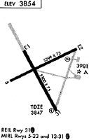
Runways
Runway Summary
| Runways: | 05/23 14/32 |
| Longest Runway: | 05/23 is 5300 ft (1615 m) long |
| Runways with an Instrument Approach: |
CTB Seaplane Base Runway Details
| Runway 05/23 | 5300 ft x 75 ft (1615 m x 23 m) | |
| Runway Length Source: | 3RD PARTY SURVEY as of 08/10/2010 | |
| Surface: | Asphalt - Excellent condition - No special surface treatment | |
| Runway Pavement Class: | 10 /F/D/Y/U | |
| Runway Edge Lights: | Medium Intensity | |
Runway Weight Bearing Capacity (in thousands of pounds) |
||
| Single Wheel Landing Gear: | 27.5 | |
| Dual Wheel Landing Gear: | 37.5 | |
Runway 05 |
Runway 23 |
|
Elevation: |
3853.8 | 3840.1 |
Latitude: |
48-36-23.3620N | 48-36-46.3490N |
Longitude: |
112-23-06.8059W | 112-21-55.9859W |
|
Runway True Alignment: |
064 | 244 |
Glide Path Angle: |
0.0 degrees | 3.0 degrees |
Traffic Pattern: |
Left | Left |
Runway Markings Type: |
Nonprecision Instrument | Nonprecision Instrument |
Runway Markings Condition: |
Good | Good |
Visual Glide Slope Indicators: |
2-Light PAPI On Left Side Of Runway | |
Threshold Crossing Height: |
39 |
| Runway 14/32 | 5300 ft x 75 ft (1615 m x 23 m) | |
| Runway Length Source: | 3RD PARTY SURVEY as of 08/10/2010 | |
| Surface: | Asphalt - Excellent condition - No special surface treatment | |
| Runway Pavement Class: | 10 /F/D/Y/U | |
| Runway Edge Lights: | Medium Intensity | |
Runway Weight Bearing Capacity (in thousands of pounds) |
||
| Single Wheel Landing Gear: | 27.5 | |
| Dual Wheel Landing Gear: | 37.5 | |
Runway 14 |
Runway 32 |
|
Elevation: |
3857.8 | 3841.6 |
Latitude: |
48-36-48.4204N | 48-36-02.1768N |
Longitude: |
112-22-55.2892W | 112-22-18.4903W |
|
Runway True Alignment: |
152 | 332 |
Glide Path Angle: |
0.0 degrees | 3.0 degrees |
Traffic Pattern: |
Left | Left |
Runway Markings Type: |
Nonprecision Instrument | Nonprecision Instrument |
Runway Markings Condition: |
Good | Good |
Visual Glide Slope Indicators: |
4-Box VASI On Left Side Of Runway | |
REIL: |
Yes | |
Threshold Crossing Height: |
42 |
Services
Fuel Available: |
MOGAS |
Landing Fees: |
No |
Parking: |
Tiedowns available |
Maps & Diagrams
CTB Sectional
Flight Planning
at skyvector.com
at skyvector.com