Location
Latitude: |
41-46-39.2760N (41.777577) |
Longitude: |
099-09-00.7620W (-99.150212) |
Elevation: |
2183.3 feet MSL (665 m MSL) |
Magnetic Variation: |
4.3 E (as of May 2024 from WMM2020 model) |
Time Zone: |
UTC -6.0 (Standard Time) UTC -5.0 (Daylight Savings Time) |
From City: |
01 N.M. SW of Burwell, Nebraska |
Found On: |
Omaha Chart |
FAA Region: |
ACE |
Contacts
Manager: |
Publicly owned: |
| DUANE BROCKMAN PO BOX 730 BURWELL, NE 68823-0730 (308) 214-0635 |
BURWELL AIRPORT AUTHORITY PO BOX 730 BURWELL, NE 68823-0730 (308) 346-5565 |
Operations
Airport Status: |
Operational |
Facility Use: |
Public |
Type: |
Airport |
Activation Date: |
11/1960 |
Control tower: |
No |
Attendance (Months/Days/Hours): |
Months/Days/Hours Unattended |
Boundary ARTCC: |
ZDV (Denver) |
Responsible ARTCC: |
ZDV (Denver) |
Lighting Schedule: |
SEE RMK |
Segmented Circle Indicator: |
Yes |
Traffic Pattern Altitude (MSL): |
3183 feet (970 m) |
NOTAMs Facility: |
OLU |
NOTAM-D Service: |
Yes |
International Airport of Entry: |
No |
Customs Landing Rights: |
No |
Military Landing Rights: |
Yes |
Civil/Military Joint Use: |
No |
Based Aircraft
| Single Engine: | 10 |
| Multi Engine: | 1 |
Annual Operations (as of 06/09/2021)
| Total Operations: | 1900 | |
| GA Local: | 950 | 50.0% |
| GA Itinerant: | 650 | 34.2% |
| Military Aircraft: | 300 | 15.8% |
Communications
| CTAF: | 122.900 |
- APCH/DEP CTL SVC PRVDD BY DENVER ARTCC (ZDV) ON FREQS 132.7/226.675 (GRAND ISLAND WEST RCAG).
Fixed Based Operators (FBOs) & Fuel
(Click on a business for detail)
Please help us keep this information up to date. This is a FREE SERVICE just like everything else on Airport Guide! If you see that a business needs to be added, modified, or deleted please fill out our Update Form.
To add, modify, or delete a business click here.
Please help us keep this information up to date. This is a FREE SERVICE just like everything else on Airport Guide! If you see that a business needs to be added, modified, or deleted please fill out our Update Form.
Area Code: 308 |
| Business Name | Frequency | Phone | Fuel Grade |
|---|
Flight Service Stations
| Primary | Alternate | |
| FSS on Field: | N | |
| FSS Name (ID): | Columbus(OLU) | |
| Frequency: | ||
| Toll Free Phone: | 1-800-WX-BRIEF |
Instrument Procedures / Charts
FAA Terminal Procedures valid from 0901Z 03/21/24 to 0901Z 04/18/24.
There are various types of charts available for an airport. They are listed in the Page Type column. Here is a legend for those types:
APD - Airport Diagram
DP - Departure Procedure Charts
HOT - Hot Spots
IAP - Instrument Approach Procedure Charts
MIN - Minimums
STAR - Standard Terminal Arrival Charts
| Page Type | Page Name | Volume | Action Since Last Cycle |
|---|---|---|---|
| IAP | RNAV (GPS) RWY 15 | NC-2 | |
| IAP | RNAV (GPS) RWY 33 | NC-2 | |
| MIN | TAKEOFF MINIMUMS | NC-2 |
Terminal Procedures are only available for airports in several countries with more being added all the time. If you are looking for a specific country's charts, please send an email to support(at)airportguide.com stating the country name. This will be used to prioritize the implementation.
Navigation Aids (Navaids) near BUB
| Dist (NM) | ID | Morse Code | Name | Type | Freq | True Hdg | Mag Hdg |
|---|---|---|---|---|---|---|---|
| 0.3 | BUB | _ . . . . . _ _ . . . | Burwell | NDB | 377 | 129 | 125 |
| 12.9 | ODX | _ _ _ _ . . _ . . _ | Ord | NDB | 356 | 135 | 131 |
| 29.9 | CUZ | _ . _ . . . _ _ _ . . | Custer County | VOR-DME | 108.20 | 234 | 230 |
| 43.1 | OBH | _ _ _ _ . . . . . . . | Wolbach | DME | 112 | 123 | 119 |
| 46.4 | ONL | _ _ _ _ . . _ . . | O'neill | VORTAC | 113.90 | 26 | 22 |
| 49.2 | BVN | _ . . . . . . _ _ . | Alaby | NDB | 332 | 92 | 88 |
| 51.4 | RBE | . _ . _ . . . . | Rock County | NDB | 341 | 338 | 334 |
| 60.4 | ANW | . _ _ . . _ _ | Ainsworth | VOR-DME | 112.70 | 322 | 317 |
| 60.7 | GRI | _ _ . . _ . . . | Grand Island | VOR-DME | 112.00 | 141 | 137 |
| 63.5 | EAR | . . _ . _ . | Kearney | VOR | 111.20 | 174 | 170 |
| 64.4 | RRX | . _ . . _ . _ . . _ | Darr | NDB | 326 | 209 | 204 |
| 66.1 | GR | _ _ . . _ . | Sancy | NDB | 380 | 144 | 140 |
| 66.7 | OZB | _ _ _ _ _ . . _ . . . | Cozad | VOR | 109.00 | 215 | 210 |
| 68.4 | DWL | _ . . . _ _ . _ . . | Willow | NDB | 353 | 217 | 212 |
| 69.3 | EA | . . _ | Anoke | NDB | 422 | 175 | 171 |
| 71.1 | TDD | _ _ . . _ . . | Thedford | VOR-DME | 108.60 | 280 | 275 |
| 72.2 | PSS | . _ _ . . . . . . . | Prosser | NDB | 338 | 154 | 150 |
| 74.9 | OF | _ _ _ . . _ . | Carsy | NDB | 510 | 84 | 80 |
| 76.8 | LB | . _ . . _ . . . | Panbe | NDB | 416 | 236 | 231 |
| 77.5 | HSI | . . . . . . . . . | Hastings | VOR-DME | 108.80 | 154 | 150 |
Nearby Airports with Fuel
Notices to Airmen (NOTAMS)
Remarks
| A110-1 | DEER ON AND INVOF ARPT. |
| A110-2 | WATERFOWL ON AND INVOF ARPT. |
| A110-3 | CNTR PIVOT IRRIGATION SYS ROTATES THRU LS OF RWY 15 APCH DRG IRRIGATION SEASON |
| A110-4 | FOR CD CTC DENVER ARTCC AT 303-651-4257. |
| A16 | (308) 214-0635 |
| A70-FUEL-10 | 0LL 24-HR SELF SVC FUEL AVBL VIA CREDIT CARD SYSTEM. |
| A81-APT | REIL RWY 15 & 33; PAPI 15 & 33; MIRL RWY 15/33 PRESET ON MED INTST UNTIL 2400; AFT 0000 TO ACTVT AND INCR INTST - CTAF. |
Runways
Runway Summary
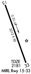
| Runways: | 15/33 |
| Longest Runway: | 15/33 is 3900 ft (1189 m) long |
| Runways with an Instrument Approach: |
BUB Airport Runway Details
| Runway 15/33 | 3900 ft x 60 ft (1189 m x 18 m) | |
| Runway Length Source: | STATE as of 08/08/2012 | |
| Surface: | Concrete - Excellent condition - No special surface treatment | |
| Runway Edge Lights: | Medium Intensity | |
Runway Weight Bearing Capacity (in thousands of pounds) |
||
| Single Wheel Landing Gear: | 30.0 | |
| Dual Wheel Landing Gear: | 30.0 | |
Runway 15 |
Runway 33 |
|
Elevation: |
2172.4 | 2183.3 |
Latitude: |
41-46-57.2613N | 41-46-21.2903N |
Longitude: |
099-09-09.9774W | 099-08-51.5480W |
|
Runway True Alignment: |
159 | 339 |
Glide Path Angle: |
3.0 degrees | 3.0 degrees |
Traffic Pattern: |
Left | Left |
Runway Markings Type: |
Nonprecision Instrument | Nonprecision Instrument |
Runway Markings Condition: |
Good | Good |
Object at End: |
ROAD | TREE |
Object Height: |
12 | 59 |
Object Marked/Lighted?: |
Marked | |
Distance from End: |
440 | 1668 |
Object Centerline Offset: |
0 ft. left and right of centerline | 284 ft. right of centerline |
Visual Glide Slope Indicators: |
2-Light PAPI On Left Side Of Runway | 2-Light PAPI On Left Side Of Runway |
REIL: |
Yes | Yes |
Threshold Crossing Height: |
40 | 40 |
Services
Airframe Repair: |
Major |
Powerplant Repair: |
Major |
Bottled Oxygen: |
None |
Bulk Oxygen: |
None |
Fuel Available: |
100LL |
Landing Fees: |
No |
Parking: |
Hangars and tiedowns available |
Maps & Diagrams
BUB Sectional
Flight Planning
at skyvector.com
at skyvector.com