Location
Latitude: |
60-46-42.8000N (60.778556) |
Longitude: |
161-50-13.8000W (-161.837167) |
Elevation: |
128.8 feet MSL (39 m MSL) |
Magnetic Variation: |
9.8 E (as of April 2024 from WMM2020 model) |
Time Zone: |
UTC -9.0 (Standard Time) UTC -8.0 (Daylight Savings Time) |
From City: |
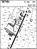
03 N.M. SW of Bethel, Alaska |
Found On: |
Mc Grath Chart |
FAA Region: |
AAL |
Contacts
Manager: |
Publicly owned: |
| JOSEPH LARAUX BOX 505 BETHEL, AK 99559 907-543-2498 |
ALASKA DOT&PF CENTRAL REGION PO BOX 196900 ANCHORAGE, AK 99519-6900 907-269-0749 |
Operations
Airport Status: |
Operational |
Facility Use: |
Public |
Type: |
Airport |
Activation Date: |
11/1958 |
Control tower: |
Yes |
Attendance (Months/Days/Hours): |
Months/Days/Hours MAY-OCT/MON-FRI/0700-2100 |
Boundary ARTCC: |
ZAN (Anchorage) |
Responsible ARTCC: |
ZAN (Anchorage) |
Lighting Schedule: |
SEE RMK |
Segmented Circle Indicator: |
Yes |
Traffic Pattern Altitude (MSL): |
1129 feet (344 m) |
NOTAMs Facility: |
BET |
NOTAM-D Service: |
Yes |
Aircraft Rescue and Firefighting: |
Class I ARFF Index: B Air Carrier Service: Scheduled Certification Date: 04/2005 |
Based Aircraft
| Single Engine: | 96 |
| Multi Engine: | 7 |
| GA Helicopters: | 7 |
Annual Operations (as of 12/31/2022)
| Total Operations: | 76406 | |
| Commercial: | 3086 | 4.0% |
| Air Taxi: | 53703 | 70.3% |
| GA Local: | 784 | 1.0% |
| GA Itinerant: | 18598 | 24.3% |
| Military Aircraft: | 235 | 0.3% |
Communications
| CTAF: | 118.700 |
| Tower: | BETHEL 118.7 Hrs: 0700-2200 1 APR - 31 OCT; 0700-2000 1 NOV - 31 MAR. |
| Ground: | 121.7 |
| Approach: | ANCHORAGE ARTCC |
| Departure: | ANCHORAGE ARTCC |
| ATIS: | 119.8 Hrs: 24 |
| ASOS: | 135.45 (907-543-5475) |
| EMERG: | 121.5 |
- APCH/DEP SVC PRVDD BY ANCHORAGE ARTCC ON FREQS 125.2/372.0 (BETHEL RCAG).
- FREQ 118.7 IS CTAF AT BETHEL SPB AND HANGAR LAKE SPB.
Fixed Based Operators (FBOs) & Fuel
(Click on a business for detail)
Please help us keep this information up to date. This is a FREE SERVICE just like everything else on Airport Guide! If you see that a business needs to be added, modified, or deleted please fill out our Update Form.
To add, modify, or delete a business click here.
Please help us keep this information up to date. This is a FREE SERVICE just like everything else on Airport Guide! If you see that a business needs to be added, modified, or deleted please fill out our Update Form.
Area Code: 907 |
| Business Name | Frequency | Phone | Fuel Grade |
|---|---|---|---|
| Hangar One Air, Inc.
Update FBO info |
Unicom 123.5 | 543-4001 | 100LL, Jet A |

|
 Independent |
100LL - 3.64 USD per gallon on 8/18/01 |
Trucks |
|
|
Independent |
Jet A - 2.63 USD per gallon on 8/18/01 |
Trucks |
| Kusko Aviation
Update FBO info |
543-3279 | ||
| Yute Air Alaska, Inc.
Website Update FBO info |
Arinc 131.25 | 543-5047 | 100LL |
Flight Service Stations
| Primary | Alternate | |
| FSS on Field: | N | |
| FSS Name (ID): | Kenai(ENA) | |
| Frequency: | ||
| Toll Free Phone: | 1-866-864-1737 |
Instrument Procedures / Charts
FAA Terminal Procedures valid from 0901Z 03/21/24 to 0901Z 04/18/24.
There are various types of charts available for an airport. They are listed in the Page Type column. Here is a legend for those types:
APD - Airport Diagram
DP - Departure Procedure Charts
HOT - Hot Spots
IAP - Instrument Approach Procedure Charts
MIN - Minimums
STAR - Standard Terminal Arrival Charts
| Page Type | Page Name | Volume | Action Since Last Cycle |
|---|---|---|---|
| APD | AIRPORT DIAGRAM | AK-1 | |
| HOT | HOT SPOT | AK-1 | |
| IAP | ILS Y OR LOC Y RWY 19R | AK-1 | |
| IAP | ILS Z OR LOC Z RWY 19R | AK-1 | |
| IAP | RNAV (GPS) RWY 01L | AK-1 | |
| IAP | RNAV (GPS) RWY 01R | AK-1 | |
| IAP | RNAV (GPS) RWY 19L | AK-1 | |
| IAP | RNAV (GPS) RWY 19R | AK-1 | |
| IAP | RNAV (GPS)-A | AK-1 | |
| IAP | VOR RWY 01L | AK-1 | |
| MIN | ALTERNATE MINIMUMS | AK-1 | |
| MIN | TAKEOFF MINIMUMS | AK-1 |
Terminal Procedures are only available for airports in several countries with more being added all the time. If you are looking for a specific country's charts, please send an email to support(at)airportguide.com stating the country name. This will be used to prioritize the implementation.
Navigation Aids (Navaids) near BET
| Dist (NM) | ID | Morse Code | Name | Type | Freq | True Hdg | Mag Hdg |
|---|---|---|---|---|---|---|---|
| 0.5 | BET | _ . . . . _ | Bethel | VORTAC | 114.10 | 45 | 35 |
| 1.3 | OSE | _ _ _ . . . . | Oscarville | NDB | 251 | 306 | 296 |
| 81.0 | ANI | . _ _ . . . | Aniak | NDB | 359 | 52 | 42 |
| 87.3 | SMA | . . . _ _ . _ | St Marys | NDB | 230 | 332 | 323 |
Nearby Airports with Fuel
| Dist (NM) | Name (Airport IDs) | True Hdg | Mag Hdg | Fuel Grade |
|---|---|---|---|---|
| 61.4 | Quinhagak Airport (KWN PAQH AQH) |
180 | 170 | 100LL |
| 81.9 | Aniak Airport (ANI PANI ANI) |
52 | 41 | 100LL, Jet A |
Notices to Airmen (NOTAMS)
Remarks
| A110-10 | WX CAMERA AVBL ON INTERNET AT HTTPS://WEATHERCAMS.FAA.GOV. |
| A110-11 | MULT PAVEMENT VARIATIONS FULL LEN OF TWY C SOUTH OF RWY 12/30. |
| A110-12 | TSNT PRKG W END OF S RAMP MRKD BY GREEN CONES. |
| A110-14 | COND RPRTG & OTR MAINT SVC AVBL DURG MAINT DUTY HR. AFT HR SVC PPR IN WRITING - AMGR. |
| A110-15 | NWS BLN LAUNCH FAC ON ARPT - SEE INSIDE BACK CVR FOR OPS DTLS. |
| A110-17 | LOCK WHEEL TURNS NA ALL SFCS. |
| A110-18 | TSA REG; SEE 49 CFR 1542. GATES & DOORS SECURED ALL TIMES. UNFAM TSNT - AMGR. |
| A110-19 | ARPT SAND SMALLER GRADATION THAN FAA RCMDD/SEE AC150/5200-30. |
| A110-8 | PSNL & EQPT MAY BE ON RWY ANY TIME. |
| A110-9 | PTARMIGAN & WATERFOWL INVOF ARPT. |
| A26 | CLSD TO ACR OPS WITH MORE THAN 30 PAX SEATS UNLESS PPR APPROVED IN WRITING BY AMGR - BOX 505, BETHEL, AK 99559. |
| A30-01R/19L | SKED & UNSKED ACR OPS WITH MORE THAN 30 PAX SEATS NA. |
| A30-12/30 | SKED & UNSKED ACR OPS WITH MORE THAN 30 PAX SEATS NA. W 1200 FT CLSD TO ACFT OVER 12500 LBS GWT APR-NOV. |
| A33-12/30 | 495 FT ASPH RWY 30 END; RMNG GRVL. |
| A47-01L | TOUCHDOWN RVR AVBL 0700-2000 1 NOV-30 MAR; 1 APR-31 OCT 0700-2200. |
| A47-19R | TOUCHDOWN RVR AVBL 0700-2000 1 NOV-30 MAR; 1 APR-31 OCT 0700-2200. |
| A70-FUEL-10 | 0 SELF-SERV FUEL NA; FUEL SVC CHARGE AFT 1800. |
| A81-APT | WHEN ATCT CLSD ACTVT HIRL RWY 01L/19R, 01R/19L, RWY 12/30; TWY LIGHTS - CTAF. ACTVT MALSR RWY 01L & 19R; REIL RWY 01R & 19L; VASI RWY 01L & 19R; PAPI RWY 01R & 19L - CTAF. |
Runways
Runway Summary
| Runways: | 01L/19R 01R/19L 12/30 |
| Longest Runway: | 01L/19R is 6400 ft (1951 m) long |
| Runways with an Instrument Approach: | 01L, 19R |
BET Airport Runway Details
| Runway 01L/19R | 6400 ft x 150 ft (1951 m x 46 m) | |
| Runway Length Source: | 3RD PARTY SURVEY as of 06/30/2011 | |
| Surface: | Asphalt - Fair condition - Saw-cut or plastic grooved | |
| Runway Pavement Class: | 41 /F/C/X/T | |
| Runway Edge Lights: | High Intensity | |
Runway Weight Bearing Capacity (in thousands of pounds) |
||
| Single Wheel Landing Gear: | 105.0 | |
| Dual Wheel Landing Gear: | 147.0 | |
| Dual Tandem Wheel Landing Gear: | 244.0 | |
Runway 01L |
Runway 19R |
|
Elevation: |
127.2 | 102.2 |
Latitude: |
60-46-18.3688N | 60-47-16.1789N |
Longitude: |
161-50-36.6126W | 161-49-45.2947W |
|
Runway True Alignment: |
023 | 203 |
ILS Type: |
MLS | ILS/DME |
Glide Path Angle: |
3.0 degrees | 3.0 degrees |
Traffic Pattern: |
Left | Left |
Runway Markings Type: |
Precision Instrument | Precision Instrument |
Runway Markings Condition: |
Fair | Fair |
Visual Glide Slope Indicators: |
4-Box VASI On Left Side Of Runway | 4-Box VASI On Left Side Of Runway |
Runway Visual Range (RVR): |
Touchdown | Touchdown |
Approach Light System: |
1,400 Foot Medium Intensity Approach Lighting System With Runway Alignment Indicator Lights | 1,400 Foot Medium Intensity Approach Lighting System With Runway Alignment Indicator Lights |
REIL: |
No | |
Threshold Crossing Height: |
39 | 52 |
Declared Distances |
||
Take Off Run Avbl. (TORA): |
6400 | 6400 |
Take Off Distance Avbl. (TODA): |
6400 | 6400 |
Actual Stop Dist. Avbl. (ASDA): |
6400 | 6400 |
Landing Dist. Avbl. (LDA): |
6400 | 6400 |
| Runway 01R/19L | 4000 ft x 75 ft (1219 m x 23 m) | |
| Runway Length Source: | 3RD PARTY SURVEY as of 06/30/2011 | |
| Surface: | Asphalt - Fair condition - No special surface treatment | |
| Runway Pavement Class: | 31 /F/C/Y/T | |
| Runway Edge Lights: | High Intensity | |
Runway 01R |
Runway 19L |
|
Elevation: |
122.1 | 116.8 |
Latitude: |
60-46-15.6239N | 60-46-51.7514N |
Longitude: |
161-50-23.7009W | 161-49-51.6199W |
|
Runway True Alignment: |
023 | 203 |
Glide Path Angle: |
3.0 degrees | 3.0 degrees |
Runway Markings Type: |
Nonprecision Instrument | Nonprecision Instrument |
Runway Markings Condition: |
Good | Good |
Visual Glide Slope Indicators: |
4-Light PAPI On Left Side Of Runway | 4-Light PAPI On Left Side Of Runway |
REIL: |
Yes | Yes |
Threshold Crossing Height: |
31 | 32 |
| Runway 12/30 | 1858 ft x 75 ft (566 m x 23 m) | |
| Runway Length Source: | 3RD PARTY SURVEY as of 06/30/2011 | |
| Surface: | Asphalt - Fair condition - No special surface treatment | |
| Runway Pavement Class: | 31 /F/C/Y/T | |
| Runway Edge Lights: | High Intensity | |
Runway 12 |
Runway 30 |
|
Elevation: |
125.6 | 126.8 |
Latitude: |
60-46-52.7378N | 60-46-41.3416N |
Longitude: |
161-50-51.6504W | 161-50-22.3796W |
|
Runway True Alignment: |
128 | 308 |
Glide Path Angle: |
0.0 degrees | 0.0 degrees |
Traffic Pattern: |
Left | Left |
REIL: |
No | No |
Services
Airframe Repair: |
Minor |
Powerplant Repair: |
Minor |
Fuel Available: |
100LL, Jet A |
Landing Fees: |
No |
Parking: |
Tiedowns available |
Maps & Diagrams
BET Sectional
Flight Planning
at skyvector.com
at skyvector.com