Location
Latitude: |
66-02-20.7000N (66.039083) |
Longitude: |
154-15-52.9000W (-154.264694) |
Elevation: |
298.6 feet MSL (91 m MSL) |
Magnetic Variation: |
13 E (as of April 2024 from WMM2020 model) |
Time Zone: |
UTC -9.0 (Standard Time) UTC -8.0 (Daylight Savings Time) |
From City: |
01 N.M. SW of Hughes, Alaska |
Found On: |
Fairbanks Chart |
FAA Region: |
AAL |
Contacts
Manager: |
Publicly owned: |
| JASON LUDINGTON 2301 PEGER RD FAIRBANKS, AK 99709 (907) 451-5280 |
ALASKA DOT&PF NORTHERN REGION 2301 PEGER RD FAIRBANKS, AK 99709 (907) 451-5280 |
Operations
Airport Status: |
Operational |
Facility Use: |
Public |
Type: |
Airport |
Activation Date: |
04/1950 |
Control tower: |
No |
Attendance (Months/Days/Hours): |
Months/Days/Hours Unattended |
Boundary ARTCC: |
ZAN (Anchorage) |
Responsible ARTCC: |
ZAN (Anchorage) |
Lighting Schedule: |
SEE RMK |
Segmented Circle Indicator: |
Yes |
Traffic Pattern Altitude (MSL): |
1299 feet (396 m) |
NOTAMs Facility: |
FAI |
NOTAM-D Service: |
Yes |
International Airport of Entry: |
No |
Customs Landing Rights: |
No |
Civil/Military Joint Use: |
No |
Based Aircraft
Annual Operations (as of 12/31/2022)
| Total Operations: | 1480 | |
| Air Taxi: | 1095 | 74.0% |
| GA Itinerant: | 365 | 24.7% |
| Military Aircraft: | 20 | 1.4% |
Communications
| CTAF: | 122.900 |
- APCH/DEP SVC PRVDD BY ANCHORAGE ARTCC (ZAN) ON 124.6/352.0 (BETTLES RCAG).
Fixed Based Operators (FBOs) & Fuel
(Click on a business for detail)
Please help us keep this information up to date. This is a FREE SERVICE just like everything else on Airport Guide! If you see that a business needs to be added, modified, or deleted please fill out our Update Form.
To add, modify, or delete a business click here.
Please help us keep this information up to date. This is a FREE SERVICE just like everything else on Airport Guide! If you see that a business needs to be added, modified, or deleted please fill out our Update Form.
Area Code: 907 |
| Business Name | Frequency | Phone | Fuel Grade |
|---|
Flight Service Stations
| Primary | Alternate | |
| FSS on Field: | N | |
| FSS Name (ID): | Fairbanks(FAI) | |
| Frequency: | ||
| Toll Free Phone: | 1-866-248-6516 |
Instrument Procedures / Charts
FAA Terminal Procedures valid from 0901Z 03/21/24 to 0901Z 04/18/24.
There are various types of charts available for an airport. They are listed in the Page Type column. Here is a legend for those types:
APD - Airport Diagram
DP - Departure Procedure Charts
HOT - Hot Spots
IAP - Instrument Approach Procedure Charts
MIN - Minimums
STAR - Standard Terminal Arrival Charts
| Page Type | Page Name | Volume | Action Since Last Cycle |
|---|---|---|---|
| IAP | RNAV (GPS) RWY 18 | AK-1 | |
| IAP | RNAV (GPS) RWY 36 | AK-1 | |
| MIN | TAKEOFF MINIMUMS | AK-1 | |
| ODP | HUGHES ONE (OBSTACLE) (RNAV) | AK-1 | |
| ODP | HUGHES ONE (OBSTACLE) (RNAV)[DELIMITER] CONT.1 | AK-1 |
Terminal Procedures are only available for airports in several countries with more being added all the time. If you are looking for a specific country's charts, please send an email to support(at)airportguide.com stating the country name. This will be used to prioritize the implementation.
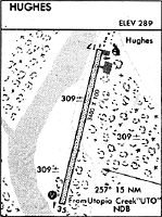
Navigation Aids (Navaids) near HUS
| Dist (NM) | ID | Morse Code | Name | Type | Freq | True Hdg | Mag Hdg |
|---|---|---|---|---|---|---|---|
| 14.2 | UTO | . . _ _ _ _ _ | Utopia Creek | NDB-DME | 272 | 100 | 87 |
| 55.2 | HSL | . . . . . . . . _ . . | Huslia | VOR-DME | 117.40 | 249 | 236 |
| 72.8 | BCC | _ . . . _ . _ . _ . _ . | Bear Creek | NDB | 212 | 134 | 121 |
| 73.1 | TAL | _ . _ . _ . . | Tanana | VOR-DME | 116.60 | 134 | 121 |
| 82.5 | EAV | . . _ . . . _ | Evansville | NDB | 391 | 50 | 36 |
| 83.5 | BTT | _ . . . _ _ | Bettles | VOR-DME | 116.00 | 50 | 36 |
| 98.9 | PPC | . _ _ . . _ _ . _ . _ . | Prospect | NDB | 340 | 60 | 46 |
Nearby Airports with Fuel
| Dist (NM) | Name (Airport IDs) | True Hdg | Mag Hdg | Fuel Grade |
|---|---|---|---|---|
| 83.9 | Bettles Airport (BTT PABT BTT) |
50 | 36 | 100LL, Jet A-1+ |
Notices to Airmen (NOTAMS)
Remarks
| A110-1 | RWY CONDITION NOT MONITORED; RECOMMEND VISUAL INSPECTION PRIOR TO LANDING. |
| A110-2 | SNOW REMOVAL OPERATIONS DURING WINTER - MONITOR CTAF. |
| A110-4 | SOUTH SAFETY AREA SOFT & RUTTED. |
| A110-5 | TWY A UNLIT. |
| A110-6 | TWY A REFLECTORS 36 INCHES TALL. |
| A110-7 | 150 FT X 100 FT TURN AROUND NORTH SIDE OF RWY. |
| A81-APT | ACTVT MIRL RWY 18/36 - CTAF. |
| A81-BCN | ACTVT ROTATING BEACON - CTAF. |
Runways
Runway Summary
| Runways: | 18/36 |
| Longest Runway: | 18/36 is 3381 ft (1031 m) long |
| Runways with an Instrument Approach: |
HUS Airport Runway Details
| Runway 18/36 | 3381 ft x 100 ft (1031 m x 30 m) | |
| Runway Length Source: | 3RD PARTY SURVEY as of 06/30/2015 | |
| Surface: | Gravel - Good condition - No special surface treatment | |
| Runway Edge Lights: | Medium Intensity | |
Runway 18 |
Runway 36 |
|
Elevation: |
298.6 | 296.7 |
Latitude: |
66-02-36.8758N | 66-02-04.5768N |
Longitude: |
154-15-43.0839W | 154-16-02.7063W |
|
Runway True Alignment: |
194 | 014 |
Glide Path Angle: |
0.0 degrees | 0.0 degrees |
Traffic Pattern: |
Left | Left |
Runway Markings Type: |
Nonstandard (other than numbers only) | Nonstandard (other than numbers only) |
Runway Markings Condition: |
Fair | Fair |
Object at End: |
TREES | TREES |
Object Height: |
15 | 15 |
Distance from End: |
0 | 0 |
Object Centerline Offset: |
108 ft. right of centerline | 105 ft. left and right of centerline |
Services
Fuel Available: |
100LL, Jet A-1+ |
Parking: |
Tiedowns available |
Other Services: |
camping and fishing supplies |
Maps & Diagrams
HUS Sectional
Flight Planning
at skyvector.com
at skyvector.com