Location
Latitude: |
38-50-25.6980N (38.840472) |
Longitude: |
082-50-50.3140W (-82.847309) |
Elevation: |
663.4 feet MSL (202 m MSL) |
Magnetic Variation: |
7.2 W (as of April 2024 from WMM2020 model) |
Time Zone: |
UTC -5.0 (Standard Time) UTC -4.0 (Daylight Savings Time) |
From City: |
10 N.M. NE of Portsmouth, Ohio |
Found On: |
Cincinnati Chart |
FAA Region: |
AGL |
Contacts
Manager: |
Publicly owned: |
| JOSH GREEN 138 BARKLOW RD PORTSMOUTH, OH 45662-8691 740-820-2700 |
SCIOTO COUNTY ARPT AUTHORITY PO BOX 245 MINFORD, OH 45653-0245 740-820-2300 |
Operations
Airport Status: |
Operational |
Facility Use: |
Public |
Type: |
Airport |
Control tower: |
No |
Attendance (Months/Days/Hours): |
Months/Days/Hours ALL/ALL/0900-1700 |
Boundary ARTCC: |
ZID (Indianapolis) |
Responsible ARTCC: |
ZID (Indianapolis) |
Lighting Schedule: |
SEE RMK |
Segmented Circle Indicator: |
No |
Traffic Pattern Altitude (MSL): |
1663 feet (507 m) |
NOTAMs Facility: |
DAY |
NOTAM-D Service: |
Yes |
International Airport of Entry: |
No |
Customs Landing Rights: |
No |
Military Landing Rights: |
Yes |
Civil/Military Joint Use: |
No |
Based Aircraft
| Single Engine: | 25 |
Annual Operations (as of 07/26/2023)
| Total Operations: | 45530 | |
| Air Taxi: | 400 | 0.9% |
| GA Local: | 27000 | 59.3% |
| GA Itinerant: | 18030 | 39.6% |
| Military Aircraft: | 100 | 0.2% |
Communications
| CTAF: | 122.800 |
| Unicom: | 122.800 |
| Approach: | HUNTINGTON 128.4 128.4 |
| Departure: | HUNTINGTON 128.4 128.4 |
| AWOS-3: | 125.175 (740-820-2500) |
Fixed Based Operators (FBOs) & Fuel
(Click on a business for detail)
Please help us keep this information up to date. This is a FREE SERVICE just like everything else on Airport Guide! If you see that a business needs to be added, modified, or deleted please fill out our Update Form.
To add, modify, or delete a business click here.
Please help us keep this information up to date. This is a FREE SERVICE just like everything else on Airport Guide! If you see that a business needs to be added, modified, or deleted please fill out our Update Form.
Area Code: 740 |
| Business Name | Frequency | Phone | Fuel Grade |
|---|---|---|---|
| Chasteen Aviation, Inc.
Update FBO info |
Unicom 122.8 | 820-2400 | 80, 100LL, Jet A |
Flight Service Stations
| Primary | Alternate | |
| FSS on Field: | ||
| FSS Name (ID): | Dayton(DAY) | |
| Frequency: | ||
| Toll Free Phone: | 1-800-WX-BRIEF |
Instrument Procedures / Charts
FAA Terminal Procedures valid from 0901Z 03/21/24 to 0901Z 04/18/24.
There are various types of charts available for an airport. They are listed in the Page Type column. Here is a legend for those types:
APD - Airport Diagram
DP - Departure Procedure Charts
HOT - Hot Spots
IAP - Instrument Approach Procedure Charts
MIN - Minimums
STAR - Standard Terminal Arrival Charts
| Page Type | Page Name | Volume | Action Since Last Cycle |
|---|---|---|---|
| IAP | RNAV (GPS) RWY 18 | EC-2 | |
| IAP | RNAV (GPS) RWY 36 | EC-2 | |
| MIN | TAKEOFF MINIMUMS | EC-2 |
Terminal Procedures are only available for airports in several countries with more being added all the time. If you are looking for a specific country's charts, please send an email to support(at)airportguide.com stating the country name. This will be used to prioritize the implementation.
Navigation Aids (Navaids) near PMH
| Dist (NM) | ID | Morse Code | Name | Type | Freq | True Hdg | Mag Hdg |
|---|---|---|---|---|---|---|---|
| 13.3 | YRK | _ . _ _ . _ . _ . _ | York | VORTAC | 112.80 | 207 | 214 |
| 20.0 | EOP | . _ _ _ . _ _ . | Waverly | NDB | 385 | 348 | 355 |
| 22.9 | PZO | . _ _ . _ _ . . _ _ _ | Peebles | NDB | 329 | 282 | 289 |
| 33.5 | AMT | . _ _ _ _ | West Union | NDB | 359 | 271 | 278 |
| 36.8 | RZT | . _ . _ _ . . _ | Ross County | NDB | 236 | 346 | 353 |
| 38.2 | UNI | . . _ _ . . . | Athens | FAN MARKER | 52 | 59 | |
| 38.5 | HOC | . . . . _ _ _ _ . _ . | Hillsboro | NDB | 278 | 302 | 309 |
| 38.7 | HNN | . . . . _ . _ . | Henderson | DME | 115.9 | 97 | 104 |
| 40.7 | XW | _ . . _ . _ _ | Flmng | NDB | 400 | 247 | 254 |
| 41.0 | ECB | . _ . _ . _ . . . | Newcombe | DME | 110.4 | 184 | 191 |
| 41.6 | XUB | _ . . _ . . _ _ . . . | Yellow Bud | VOR | 112.50 | 351 | 358 |
| 41.9 | UGS | . . _ _ _ . . . . | University | NDB | 250 | 53 | 60 |
| 52.2 | CSS | _ . _ . . . . . . . | Court House | NDB | 414 | 331 | 338 |
| 54.7 | DD | _ . . _ . . | Cobbs | NDB | 253 | 351 | 358 |
| 56.8 | MXQ | _ _ _ . . _ _ _ . _ | Midwest | VOR-DME | 112.90 | 308 | 315 |
| 56.9 | HW | . . . . . _ _ | Cubla | NDB | 299 | 303 | 310 |
| 57.0 | IL | . . . _ . . | Airbo | NDB | 407 | 313 | 320 |
| 58.2 | LCK | . _ . . _ . _ . _ . _ | Rickenbacker | TACAN | 69X | 356 | 363 |
| 58.5 | HVQ | . . . . . . . _ _ _ . _ | Charleston | VOR-DME | 117.40 | 119 | 127 |
| 61.0 | BU | _ . . . . . _ | Boutn | NDB | 230 | 344 | 351 |
Nearby Airports with Fuel
Notices to Airmen (NOTAMS)
Remarks
| A110-1 | HILL OBSTN LGTS 460 FT ABV ARPT (1124 FT MSL) 1 MI S & 410 FT ABV ARPT (1074 FT MSL) 1/2 MI NW. |
| A110-2 | NO LINE OF SIGHT BTN RWY ENDS. |
| A110-3 | FOR CD CTC HUNTINGTON ATCT AT 304-453-2490. |
| A24 | LDG FEE FOR TURBINE ACFT WAIVED WITH FUEL PURCHASE, CTC ARPT FOR DTLS. |
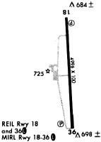
| A81-APT | ACTVT REIL RWY 18 & 36; MIRL RWY 18/36 - CTAF. PAPI RWY 18 & 36 OPR CONSLY. |
| E111 | ESTABD BFR 1959. |
Runways
Runway Summary
| Runways: | 18/36 |
| Longest Runway: | 18/36 is 5001 ft (1524 m) long |
| Runways with an Instrument Approach: |
PMH Airport Runway Details
| Runway 18/36 | 5001 ft x 100 ft (1524 m x 30 m) | |
| Runway Length Source: | 3RD PARTY SURVEY as of 09/04/2020 | |
| Surface: | Asphalt - Excellent condition - No special surface treatment | |
| Runway Edge Lights: | Medium Intensity | |
Runway Weight Bearing Capacity (in thousands of pounds) |
||
| Single Wheel Landing Gear: | 30.0 | |
| Dual Wheel Landing Gear: | 42.0 | |
| Dual Tandem Wheel Landing Gear: | 70.0 | |
Runway 18 |
Runway 36 |
|
Elevation: |
659.7 | 654.9 |
Latitude: |
38-50-50.3931N | 38-50-01.0020N |
Longitude: |
082-50-51.5364W | 082-50-49.0924W |
|
Runway True Alignment: |
178 | 358 |
Glide Path Angle: |
3.0 degrees | 3.0 degrees |
Traffic Pattern: |
Left | Left |
Runway Markings Type: |
Nonprecision Instrument | Nonprecision Instrument |
Runway Markings Condition: |
Good | Good |
Visual Glide Slope Indicators: |
4-Light PAPI On Left Side Of Runway | 4-Light PAPI On Left Side Of Runway |
REIL: |
Yes | Yes |
Touchdown Lights: |
No | No |
Centerline Lights: |
No | No |
Threshold Crossing Height: |
25 | 31 |
Services
Airframe Repair: |
Major |
Powerplant Repair: |
Major |
Fuel Available: |
100LL |
Landing Fees: |
No |
Parking: |
Hangars and tiedowns available |
Maps & Diagrams
PMH Sectional
Flight Planning
at skyvector.com
at skyvector.com