Location
Latitude: |
18-15-20.4700N (18.255686) |
Longitude: |
067-08-54.4980W (-67.148472) |
Elevation: |
28.7 feet MSL (9 m MSL) |
Magnetic Variation: |
13.1 W (as of April 2024 from WMM2020 model) |
Time Zone: |
UTC -4.0 (Standard Time) UTC -4.0 (Daylight Savings Time) |
From City: |
03 N.M. N of Mayaguez, Puerto Rico |
Found On: |
Puerto Rico-Virgin Islands Chart |
FAA Region: |
ASO |
Contacts
Manager: |
Publicly owned: |
| WILLIAM FEBLES BOX 710 MAYAGUEZ, PR 00681-0710 787-833-0148 |
PUERTO RICO PORTS AUTH P.O. BOX 362829 SAN JUAN, PR 00932-2829 787-729-8715 |
Operations
Airport Status: |
Operational |
Facility Use: |
Public |
Type: |
Airport |
Activation Date: |
05/1947 |
Control tower: |
No |
Attendance (Months/Days/Hours): |
Months/Days/Hours ALL/MON-FRI/0730-1600 |
Boundary ARTCC: |
ZSU (San Juan) |
Responsible ARTCC: |
ZSU (San Juan) |
Lighting Schedule: |
SEE RMK |
Segmented Circle Indicator: |
Yes |
Traffic Pattern Altitude (MSL): |
1029 feet (314 m) |
NOTAMs Facility: |
TJMZ |
NOTAM-D Service: |
Yes |
International Airport of Entry: |
No |
Customs Landing Rights: |
No |
Military Landing Rights: |
Yes |
Civil/Military Joint Use: |
No |
Based Aircraft
| Single Engine: | 17 |
| Multi Engine: | 1 |
Annual Operations (as of 12/31/2021)
| Total Operations: | 4242 | |
| Air Taxi: | 2632 | 62.0% |
| GA Local: | 800 | 18.9% |
| GA Itinerant: | 400 | 9.4% |
| Military Aircraft: | 410 | 9.7% |
Communications
| CTAF: | 122.800 |
| Unicom: | 122.800 |
- APCH/DEP SVC PRVDD BY SAN JUAN CERAP ON FREQS 118.75/269.0 (EL YUNQUE RCAG).
- CLNC DEL PRVDD BY SAN JUAN CERAP ON FREQ 121.7.
Fixed Based Operators (FBOs) & Fuel
(Click on a business for detail)
Please help us keep this information up to date. This is a FREE SERVICE just like everything else on Airport Guide! If you see that a business needs to be added, modified, or deleted please fill out our Update Form.
To add, modify, or delete a business click here.
Please help us keep this information up to date. This is a FREE SERVICE just like everything else on Airport Guide! If you see that a business needs to be added, modified, or deleted please fill out our Update Form.
Area Code: 787 |
| Business Name | Frequency | Phone | Fuel Grade |
|---|
Flight Service Stations
| Primary | Alternate | |
| FSS on Field: | N | |
| FSS Name (ID): | San Juan(SJU) | |
| Frequency: | ||
| Toll Free Phone: | 1-800-WX-BRIEF |
Instrument Procedures / Charts
FAA Terminal Procedures valid from 0901Z 03/21/24 to 0901Z 04/18/24.
There are various types of charts available for an airport. They are listed in the Page Type column. Here is a legend for those types:
APD - Airport Diagram
DP - Departure Procedure Charts
HOT - Hot Spots
IAP - Instrument Approach Procedure Charts
MIN - Minimums
STAR - Standard Terminal Arrival Charts
| Page Type | Page Name | Volume | Action Since Last Cycle |
|---|---|---|---|
| APD | AIRPORT DIAGRAM | SE-3 | Changed |
| IAP | RNAV (GPS) RWY 09 | SE-3 | Changed |
| IAP | VOR RWY 09 | SE-3 | Changed |
| MIN | ALTERNATE MINIMUMS | SE-3 | |
| MIN | TAKEOFF MINIMUMS | SE-3 |
Terminal Procedures are only available for airports in several countries with more being added all the time. If you are looking for a specific country's charts, please send an email to support(at)airportguide.com stating the country name. This will be used to prioritize the implementation.
Navigation Aids (Navaids) near MAZ
| Dist (NM) | ID | Morse Code | Name | Type | Freq | True Hdg | Mag Hdg |
|---|---|---|---|---|---|---|---|
| 0.2 | MAZ | _ _ . _ _ _ . . | Mayaguez | VOR-DME | 110.60 | 288 | 301 |
| 0.3 | MAZ | _ _ . _ _ _ . . | Mayaguez | NDB | 254 | 243 | 256 |
| 14.7 | BQN | _ . . . _ _ . _ _ . | Borinquen | VORTAC | 113.50 | 8 | 21 |
| 39.2 | PSE | . _ _ . . . . . | Ponce | DME | 113 | 126 | |
| 43.8 | DDP | _ . . _ . . . _ _ . | Dorado | NDB | 391 | 72 | 85 |
| 61.0 | SJ | . . . . _ _ _ | Patty | NDB | 330 | 81 | 94 |
| 67.0 | SJU | . . . . _ _ _ . . _ | San Juan | VORTAC | 114.00 | 79 | 92 |
| 72.0 | PCA | Punta Cana | NDB | 425 | 285 | 298 | |
| 72.7 | PNA | . _ _ . _ . . _ | Punta Cana | VOR-DME | 112.70 | 285 | 298 |
| 85.8 | NRR | _ . . _ . . _ . | Roosevelt Roads | TACAN | 113.80 | 90 | 103 |
Nearby Airports with Fuel
| Dist (NM) | Name (Airport IDs) | True Hdg | Mag Hdg | Fuel Grade |
|---|---|---|---|---|
| 14.4 | Rafael Hernandez Airport (BQN TJBQ BQN) |
4 | 17 | 100, Jet A-1 |
| 61.0 | Fernando Luis Ribas Dominicci Airport (SIG TJIG SIG) |
78 | 92 | 100, Jet A |
| 66.2 | Luis Munoz Marin International Airport (SJU TJSJ SJU) |
80 | 94 | 100, Jet A+, Jet A++ |
| 85.8 | Jose Aponte De La Torre Airport (TJRV RVR) |
90 | 104 | 100LL, Jet A |
Notices to Airmen (NOTAMS)
Remarks
| A110-2 | BIRDS ON AND INVOF ARPT. |
| A110-3 | FOR CD IF FREQ ARE OTS CTC SAN JUAN CERAP AT 787-253-8664/8667 |
| A110-4 | ULTRALIGHT ACTIVITY. |
| A24 | FEE FOR ALL ACFT. |
| A52-09 | 47 FT LIGHTED/MARKED POWER LINES, 1800 FT DSTC, 0 FT B, 34:1. |
| A57-09 | 30 FT TREE, 200 FT DSTC AT BEGINNING OF THE APCH SFC, 190 FT L, OBSTN CLNC 0:1. |
| A58-27 | 20' TREES, 57 FT DSTC, 140 FT L. |
| A81-APT | RY 09/27 MIRLS SS-SR. ACTVT PAPI RYS 09 & 27, REILS RY 9 - CTAF. |
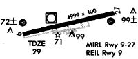
Runways
Runway Summary
| Runways: | 09/27 |
| Longest Runway: | 09/27 is 4999 ft (1524 m) long |
| Runways with an Instrument Approach: |
MAZ Airport Runway Details
| Runway 09/27 | 4999 ft x 75 ft (1524 m x 23 m) | |
| Runway Length Source: | 3RD PARTY SURVEY as of 10/23/2023 | |
| Surface: | Asphalt - Good condition - No special surface treatment | |
| Runway Edge Lights: | Medium Intensity | |
Runway Weight Bearing Capacity (in thousands of pounds) |
||
| Single Wheel Landing Gear: | 85.0 | |
| Dual Wheel Landing Gear: | 108.0 | |
| Dual Tandem Wheel Landing Gear: | 170.0 | |
Runway 09 |
Runway 27 |
|
Elevation: |
16.2 | 24.6 |
Latitude: |
18-15-14.6859N | 18-15-26.2563N |
Longitude: |
067-09-19.7212W | 067-08-29.2895W |
|
Runway True Alignment: |
076 | 256 |
Glide Path Angle: |
3.0 degrees | 3.5 degrees |
Traffic Pattern: |
Left | Left |
Runway Markings Type: |
Nonprecision Instrument | Nonprecision Instrument |
Runway Markings Condition: |
Good | Good |
Object at End: |
TREE | TREES |
Object Height: |
16 | 30 |
Distance from End: |
338 | 200 |
Object Centerline Offset: |
127 ft. left of centerline | 190 ft. left of centerline |
Visual Glide Slope Indicators: |
4-Light PAPI On Left Side Of Runway | 4-Light PAPI On Left Side Of Runway |
REIL: |
Yes | |
Threshold Crossing Height: |
40 | 51 |
Threshold Elevation: |
17.5 | |
Displaced Threshold: |
300 | |
Threshold Latitude: |
18-15-15.3799N | |
Threshold Longitude: |
067-09-16.6943W |
Services
Airframe Repair: |
Major |
Powerplant Repair: |
Major |
Bottled Oxygen: |
None |
Bulk Oxygen: |
Low Pressure |
Fuel Available: |
100LL, Jet A |
Landing Fees: |
Yes |
Parking: |
Tiedowns available |
Maps & Diagrams
MAZ Sectional
Flight Planning
at skyvector.com
at skyvector.com