Location
Latitude: |
35-10-58.0010N (35.182778) |
Longitude: |
103-36-11.5000W (-103.603194) |
Elevation: |
4064.9 feet MSL (1239 m MSL) |
Magnetic Variation: |
6.5 E (as of May 2024 from WMM2020 model) |
Time Zone: |
UTC -7.0 (Standard Time) UTC -6.0 (Daylight Savings Time) |
From City: |
06 N.M. E of Tucumcari, New Mexico |
Found On: |
Albuquerque Chart |
FAA Region: |
ASW |
Contacts
Manager: |
Publicly owned: |
| JIM SEWELL 6352 QRA1 ROAD TUCUMCARI, NM 88401 575-461-3229 |
CITY OF TUCUMCARI BOX 1188 TUCUMCARI, NM 88401 575-461-3451 |
Operations
Airport Status: |
Operational |
Facility Use: |
Public |
Type: |
Airport |
Activation Date: |
08/1941 |
Control tower: |
No |
Attendance (Months/Days/Hours): |
Months/Days/Hours ALL/ALL/0700-1700 |
Boundary ARTCC: |
ZAB (Albuquerque) |
Responsible ARTCC: |
ZAB (Albuquerque) |
Lighting Schedule: |
SEE RMK |
Segmented Circle Indicator: |
Yes |
Traffic Pattern Altitude (MSL): |
5065 feet (1544 m) |
NOTAMs Facility: |
TCC |
NOTAM-D Service: |
Yes |
International Airport of Entry: |
No |
Customs Landing Rights: |
No |
Military Landing Rights: |
Yes |
Civil/Military Joint Use: |
No |
Based Aircraft
| Single Engine: | 10 |
| GA Helicopters: | 2 |
Annual Operations (as of 03/30/2021)
| Total Operations: | 25300 | |
| Air Taxi: | 600 | 2.4% |
| GA Local: | 4400 | 17.4% |
| GA Itinerant: | 20000 | 79.1% |
| Military Aircraft: | 300 | 1.2% |
Communications
| CTAF: | 122.950 |
| Unicom: | 122.950 |
| ASOS: | 119.275 (575-461-4940) |
- APCH/DEP SVC PRVDD BY ALBUQUERQUE ARTCC (ZAB) ON FREQS 126.85/285.6 (TUCUMCARI RCAG).
Fixed Based Operators (FBOs) & Fuel
(Click on a business for detail)
Please help us keep this information up to date. This is a FREE SERVICE just like everything else on Airport Guide! If you see that a business needs to be added, modified, or deleted please fill out our Update Form.
To add, modify, or delete a business click here.
Please help us keep this information up to date. This is a FREE SERVICE just like everything else on Airport Guide! If you see that a business needs to be added, modified, or deleted please fill out our Update Form.
Area Code: 505 |
| Business Name | Frequency | Phone | Fuel Grade |
|---|---|---|---|
| City of Tucumcari / Tucumcari Aviation
Update FBO info |
Unicom 122.95 | 461-3229, after hours call 461-2160 | 100LL, Jet A |
Flight Service Stations
| Primary | Alternate | |
| FSS on Field: | N | |
| FSS Name (ID): | Albuquerque(ABQ) | |
| Frequency: | ||
| Toll Free Phone: | 1-800-WX-BRIEF |
Instrument Procedures / Charts
FAA Terminal Procedures valid from 0901Z 03/21/24 to 0901Z 04/18/24.
There are various types of charts available for an airport. They are listed in the Page Type column. Here is a legend for those types:
APD - Airport Diagram
DP - Departure Procedure Charts
HOT - Hot Spots
IAP - Instrument Approach Procedure Charts
MIN - Minimums
STAR - Standard Terminal Arrival Charts
| Page Type | Page Name | Volume | Action Since Last Cycle |
|---|---|---|---|
| IAP | RNAV (GPS) RWY 03 | SW-1 | |
| IAP | RNAV (GPS) RWY 21 | SW-1 | |
| IAP | RNAV (GPS) RWY 26 | SW-1 | |
| IAP | VOR RWY 21 | SW-1 | |
| MIN | TAKEOFF MINIMUMS | SW-1 |
Terminal Procedures are only available for airports in several countries with more being added all the time. If you are looking for a specific country's charts, please send an email to support(at)airportguide.com stating the country name. This will be used to prioritize the implementation.
Navigation Aids (Navaids) near TCC
| Dist (NM) | ID | Morse Code | Name | Type | Freq | True Hdg | Mag Hdg |
|---|---|---|---|---|---|---|---|
| 0.2 | TCC | _ _ . _ . _ . _ . | Tucumcari | VORTAC | 113.60 | 98 | 92 |
| 50.1 | CVS | _ . _ . . . . _ . . . | Cannon | TACAN | 111.60 | 163 | 157 |
| 54.2 | CV | _ . _ . . . . _ | Hisan | NDB | 335 | 156 | 150 |
| 55.8 | TXO | _ _ . . _ _ _ _ | Texico | VORTAC | 112.20 | 137 | 131 |
| 65.8 | HRX | . . . . . _ . _ . . _ | Hereford | NDB | 341 | 106 | 100 |
| 70.6 | ACH | . _ _ . _ . . . . . | Anton Chico | VORTAC | 117.80 | 266 | 259 |
| 75.1 | DHT | _ . . . . . . _ | Dalhart | VORTAC | 112.00 | 43 | 37 |
| 78.8 | CAO | _ . _ . . _ _ _ _ | Clayton | NDB | 332 | 16 | 10 |
| 80.2 | FTI | . . _ . _ . . | Fort Union | VORTAC | 117.30 | 291 | 284 |
| 88.2 | AM | . _ _ _ | Pande | NDB | 251 | 90 | 84 |
| 93.4 | PNH | . _ _ . _ . . . . . | Panhandle | VORTAC | 116.60 | 87 | 81 |
| 96.8 | LIU | . _ . . . . . . _ | Littlefield | NDB | 212 | 141 | 135 |
| 99.9 | CIM | _ . _ . . . _ _ | Cimarron | VORTAC | 116.40 | 322 | 315 |
Nearby Airports with Fuel
| Dist (NM) | Name (Airport IDs) | True Hdg | Mag Hdg | Fuel Grade |
|---|---|---|---|---|
| 51.4 | Fort Sumner Municipal Airport (FSU KFSU FSU) |
216 | 209 | 100LL |
| 52.2 | Clovis Regional Airport (CVN KCVN CVN) |
150 | 144 | 100LL, Jet A |
| 53.2 | Santa Rosa Route 66 Airport (KSXU SXU) |
254 | 247 | 100LL, Jet A |
| 63.0 | Portales Municipal Airport (KPRZ PRZ) |
171 | 165 | 100LL, Jet A |
| 65.7 | Hereford Municipal Airport (KHRX HRX) |
106 | 100 | 100LL, Jet A |
| 72.0 | Dalhart Municipal Airport (DHT KDHT DHT) |
45 | 39 | 100LL, Jet A-1 |
| 79.0 | Clayton Municipal Airpark Airport (CAO KCAO CAO) |
16 | 10 | 100LL, Jet A |
| 79.5 | Miller Airfield Airport (25TS) |
46 | 40 | 100LL, MOGAS |
| 80.4 | Las Vegas Municipal Airport (LVS KLVS LVS) |
291 | 284 | 100LL, Jet A-1 |
| 85.0 | Buffalo Airport (1E7) |
94 | 88 | 100LL, MOGAS |
| 87.6 | Moore County Airport (KDUX DUX) |
62 | 56 | 100LL, Jet A |
| 93.0 | Rick Husband Amarillo International Airport (AMA KAMA AMA) |
88 | 82 | 100LL, Jet A-1+ |
| 97.0 | City Of Tulia/Swisher County Municipal Airport (I06) |
111 | 105 | 100LL |
Notices to Airmen (NOTAMS)
Remarks
| A110-1 | EMERGENCY CONTACT: 575-461-2280 (DISPATCH). |
| A110-2 | FOR CD IF UNA TO CTC ON FSS FREQ, CTC ALBUQUERQUE ARTCC AT 505-856-4561. |
| A17 | EXCEPT FEDERAL HOLIDAYS |
| A70-FUEL-10 | 0LL FUEL AVBL AFT HRS SELF SERVE WITH MAJOR CREDIT CARD. |
| A75 | CALL 575-461-3229 FOR AVAILABILITY |
| A81-APT | ACTVT VASI RWY 21; MIRL RWY 03/21 & 08/26 - CTAF. |
Runways
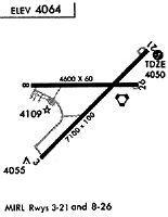
Runway Summary
| Runways: | 03/21 08/26 |
| Longest Runway: | 03/21 is 7104 ft (2165 m) long |
| Runways with an Instrument Approach: |
TCC Airport Runway Details
| Runway 03/21 | 7104 ft x 100 ft (2165 m x 30 m) | |
| Runway Length Source: | 3RD PARTY SURVEY as of 06/27/2011 | |
| Surface: | Asphalt - Good condition - No special surface treatment | |
| Runway Pavement Class: | 10 /F/C/Y/T | |
| Runway Edge Lights: | Medium Intensity | |
Runway Weight Bearing Capacity (in thousands of pounds) |
||
| Single Wheel Landing Gear: | 25.0 | |
Runway 03 |
Runway 21 |
|
Elevation: |
4039.7 | 4047.0 |
Latitude: |
35-10-29.5588N | 35-11-19.1955N |
Longitude: |
103-36-40.1597W | 103-35-39.6132W |
|
Runway True Alignment: |
045 | 225 |
Glide Path Angle: |
0.0 degrees | 3.0 degrees |
Traffic Pattern: |
Left | Left |
Runway Markings Type: |
Nonprecision Instrument | Nonprecision Instrument |
Runway Markings Condition: |
Poor | Poor |
Object at End: |
TREE | TREE |
Object Height: |
19 | 9 |
Distance from End: |
840 | 335 |
Object Centerline Offset: |
100 ft. right of centerline | 200 ft. right of centerline |
Visual Glide Slope Indicators: |
4-Box VASI On Left Side Of Runway | |
Threshold Crossing Height: |
52 |
| Runway 08/26 | 4600 ft x 60 ft (1402 m x 18 m) | |
| Runway Length Source: | 3RD PARTY SURVEY as of 06/27/2011 | |
| Surface: | Asphalt - Good condition - No special surface treatment | |
| Runway Pavement Class: | 6 /F/D/Y/T | |
| Runway Edge Lights: | Medium Intensity | |
Runway Weight Bearing Capacity (in thousands of pounds) |
||
| Single Wheel Landing Gear: | 12.0 | |
Runway 08 |
Runway 26 |
|
Elevation: |
4064.9 | 4036.0 |
Latitude: |
35-11-03.5590N | 35-11-03.5282N |
Longitude: |
103-36-41.7502W | 103-35-46.3433W |
|
Runway True Alignment: |
090 | 270 |
Glide Path Angle: |
0.0 degrees | 0.0 degrees |
Traffic Pattern: |
Left | Left |
Runway Markings Type: |
Nonprecision Instrument | Nonprecision Instrument |
Runway Markings Condition: |
Fair | Fair |
Object Centerline Offset: |
100 ft. right of centerline | 200 ft. right of centerline |
Services
Bottled Oxygen: |
None |
Bulk Oxygen: |
None |
Fuel Available: |
100LL |
Landing Fees: |
No |
Parking: |
Hangars and tiedowns available |
Maps & Diagrams
TCC Sectional
Flight Planning
at skyvector.com
at skyvector.com