
Location
Latitude: |
33-57-53.2864S (-33.964802) |
Longitude: |
018-36-06.1194E (18.6017) |
Elevation: |
151 feet MSL (46 m MSL) |
Magnetic Variation: |
26 W (as of May 2024 from WMM2020 model) |
Time Zone: |
UTC +2.0 (Standard Time) UTC +2.0 (Daylight Savings Time) |
Contacts
Manager: |
: |
Operations
Airport Status: |
Operational |
Facility Use: |
Public |
Type: |
Airport |
Traffic Pattern Altitude (MSL): |
1151 feet (351 m) |
Based Aircraft
Annual Operations (as of )
Communications
| CTAF: | 128.55 |
| CTAF: | 127.5 |
| CTAF: | 120 |
| CTAF: | 125.7 |
| CTAF: | 126 |
| CTAF: | 126.7 |
| CTAF: | 122.4 |
| CTAF: | 119.4 |
| CTAF: | 118.4 |
| Tower: | 118.1 |
| Apron Control: | 122.65 |
| Ground: | 121.9 |
| Approach: | 119.7 |
| ATIS: | 127 |
| Long Range ATIS: | 127.6 |
| MISC: | 120 |
| MISC: | 120.6 |
| MISC: | 123.4 |
| Director: | 124.5 |
| MISC: | 112.7 |
| MISC: | 119.6 |
| MISC: | 135.5 |
| MISC: | 118.8 |
| MISC: | 124 |
| MISC: | 117.5 |
| MISC: | 122.4 |
| MISC: | 118.8 |
| MISC: | 125.8 |
| MISC: | 122.8 |
| MISC: | 124.8 |
| MISC: | 122.4 |
| MISC: | 124.8 |
Fixed Based Operators (FBOs) & Fuel
(Click on a business for detail)
Please help us keep this information up to date. This is a FREE SERVICE just like everything else on Airport Guide! If you see that a business needs to be added, modified, or deleted please fill out our Update Form.
To add, modify, or delete a business click here.
Please help us keep this information up to date. This is a FREE SERVICE just like everything else on Airport Guide! If you see that a business needs to be added, modified, or deleted please fill out our Update Form.
| Business Name | Frequency | Phone | Fuel Grade |
|---|
Flight Service Stations
| Primary | Alternate | |
| FSS on Field: | ||
| FSS Name (ID): | ||
| Frequency: | ||
| Toll Free Phone: |
Instrument Procedures / Charts
Terminal Procedures are only available for airports in several countries with more being added all the time. If you are looking for a specific country's charts, please send an email to support(at)airportguide.com stating the country name. This will be used to prioritize the implementation.
Navigation Aids (Navaids) near CPT
| Dist (NM) | ID | Morse Code | Name | Type | Freq | True Hdg | Mag Hdg |
|---|---|---|---|---|---|---|---|
| 0.3 | CTV | Cape Town | VORTAC | 115.70 | 149 | 175 | |
| 5.5 | CB | Cape Town | NDB | 463 | 345 | 371 | |
| 15.4 | RIV | Robben Island | VOR-DME | 117.60 | 309 | 335 | |
| 43.4 | SVV | Somersveld | VOR | 113.00 | 351 | 377 | |
| 44.1 | WY | Wolseley | NDB | 248 | 41 | 67 | |
| 44.5 | WC | Worcester | NDB | 335 | 66 | 92 | |
| 50.1 | GE | Greyton | NDB | 270 | 96 | 122 | |
| 62.9 | LWV | Langebaanweg | VORTAC | 117.00 | 339 | 364 | |
| 63.2 | LW | Langebaanweg | NDB | 345 | 338 | 363 | |
| 74.9 | KK | Kapteinskop | NDB | 267 | 358 | 383 | |
| 89.0 | OBV | Overberg | VORTAC | 115.40 | 113 | 140 | |
| 91.6 | OB | Overberg | NDB | 428 | 114 | 141 | |
| 96.8 | SWV | Swellendam | VOR | 114.40 | 94 | 121 |
Nearby Airports with Fuel
| Dist (NM) | Name (Airport IDs) | True Hdg | Mag Hdg | Fuel Grade |
|---|---|---|---|---|
| 65.4 | Robertson Airport (ROD FARS) |
82 | 109 | 100LL Avgas |
Notices to Airmen (NOTAMS)
Remarks
No remarks for this landing facility
Runways
Runway Summary
| Runways: | 01/19 16/34 |
| Longest Runway: | 01/19 is 10502 ft (3201 m) long |
| Runways with an Instrument Approach: |
CPT Airport Runway Details
| Runway 01/19 | 10502 ft x 200 ft (3201 m x 61 m) | |
| Runway Edge Lights: | Yes Intensity | |
Runway 01 |
Runway 19 |
|
Elevation: |
144 | 147 |
Latitude: |
-33.9877014160 | -33.9598007202 |
Longitude: |
18.608900070190 | 18.600000381469 |
|
Runway True Alignment: |
346 | 166 |
Glide Path Angle: |
0.0 degrees | 0.0 degrees |
REIL: |
Yes | Yes |
Threshold Elevation: |
144 | 147 |
| Runway 16/34 | 5581 ft x 151 ft (1701 m x 46 m) | |
| Runway Edge Lights: | Yes Intensity | |
Runway 16 |
Runway 34 |
|
Elevation: |
143 | 151 |
Latitude: |
-33.9613990783 | -33.9723014831 |
Longitude: |
18.597499847412 | 18.610399246215 |
|
Runway True Alignment: |
136 | 316 |
Glide Path Angle: |
0.0 degrees | 0.0 degrees |
REIL: |
Yes | Yes |
Threshold Elevation: |
143 | 151 |
Services
Fuel Available: |
100LL Avgas |
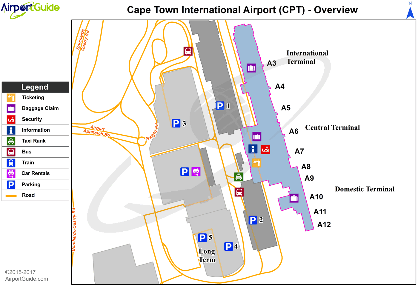
Maps & Diagrams
CPT Sectional
Flight Planning
at skyvector.com
at skyvector.com
