
Location
Latitude: |
26-08-21.12S (-26.1392) |
Longitude: |
028-14-45.6E (28.246) |
Elevation: |
5558 feet MSL (1694 m MSL) |
Magnetic Variation: |
19.8 W (as of May 2024 from WMM2020 model) |
Time Zone: |
UTC +2.0 (Standard Time) UTC +2.0 (Daylight Savings Time) |
Contacts
Manager: |
: |
Operations
Airport Status: |
Operational |
Facility Use: |
Public |
Type: |
Airport |
Traffic Pattern Altitude (MSL): |
6558 feet (1999 m) |
Based Aircraft
Annual Operations (as of )
Communications
| CTAF: | 122.4 |
| CTAF: | 122.4 |
| CTAF: | 119.8 |
| CTAF: | 122.3 |
| CTAF: | 122.3 |
| CTAF: | 122.4 |
| CTAF: | 119.8 |
| CTAF: | 122.4 |
| CTAF: | 123.4 |
| MISC: | 119.6 |
| MISC: | 122.3 |
| MISC: | 124.3 |
| MISC: | 124.3 |
| MISC: | 119.8 |
| MISC: | 122.1 |
| MISC: | 122.3 |
| MISC: | 124.3 |
| MISC: | 116.9 |
| MISC: | 119.6 |
| MISC: | 120.7 |
| MISC: | 116.9 |
| MISC: | 119.6 |
| MISC: | 120.7 |
| MISC: | 116.9 |
| MISC: | 119.6 |
| MISC: | 120.7 |
| MISC: | 122.3 |
| MISC: | 123.9 |
Fixed Based Operators (FBOs) & Fuel
(Click on a business for detail)
Please help us keep this information up to date. This is a FREE SERVICE just like everything else on Airport Guide! If you see that a business needs to be added, modified, or deleted please fill out our Update Form.
To add, modify, or delete a business click here.
Please help us keep this information up to date. This is a FREE SERVICE just like everything else on Airport Guide! If you see that a business needs to be added, modified, or deleted please fill out our Update Form.
| Business Name | Frequency | Phone | Fuel Grade |
|---|
Flight Service Stations
| Primary | Alternate | |
| FSS on Field: | ||
| FSS Name (ID): | ||
| Frequency: | ||
| Toll Free Phone: |
Instrument Procedures / Charts
Terminal Procedures are only available for airports in several countries with more being added all the time. If you are looking for a specific country's charts, please send an email to support(at)airportguide.com stating the country name. This will be used to prioritize the implementation.
Navigation Aids (Navaids) near JNB
| Dist (NM) | ID | Morse Code | Name | Type | Freq | True Hdg | Mag Hdg |
|---|---|---|---|---|---|---|---|
| 1.3 | JSV | Johannesburg | VOR-DME | 115.20 | 216 | 236 | |
| 5.7 | JB | Johannesburg | NDB | 202 | 10 | 30 | |
| 8.1 | RAV | Rand | VOR-DME | 117.70 | 217 | 237 | |
| 8.9 | RDW | Rand | NDB | 288 | 210 | 230 | |
| 10.5 | GC | Grand Central | NDB | 373 | 326 | 346 | |
| 13.2 | WK | Waterkloof | NDB | 330 | 356 | 376 | |
| 13.4 | RD | Rand | NDB | 308 | 218 | 238 | |
| 17.1 | RA | Rand | NDB | 338 | 176 | 196 | |
| 17.3 | WL | Waterkloof | NDB | 315 | 356 | 376 | |
| 18.4 | WKV | Waterkloof | VORTAC | 116.90 | 355 | 375 | |
| 21.2 | LIV | Lanseria | VOR-DME | 117.40 | 302 | 322 | |
| 23.2 | LA | Lanseria | NDB | 270 | 289 | 309 | |
| 26.9 | MEV | Bronkhorstspruit | VORTAC | 114.30 | 39 | 59 | |
| 27.6 | NMT | Meyerton | NDB | 385 | 204 | 224 | |
| 29.1 | WB | Wonderboom | NDB | 258 | 5 | 24 | |
| 29.1 | WR | Wonderboom | NDB | 230 | 359 | 378 | |
| 30.4 | VV | Vereeniging | NDB | 460 | 210 | 230 | |
| 30.8 | MC | Roodeplaat | NDB | 357 | 12 | 31 | |
| 33.5 | HGV | Heidelberg | VOR | 116.70 | 176 | 196 | |
| 35.6 | HBV | Hartebeespoortdam | VOR | 112.10 | 321 | 340 |
Nearby Airports with Fuel
| Dist (NM) | Name (Airport IDs) | True Hdg | Mag Hdg | Fuel Grade |
|---|---|---|---|---|
| 70.0 | Middelburg Airport (FAMB) |
67 | 87 | 100LL AvGas, Jet A1 |
Notices to Airmen (NOTAMS)
Remarks
No remarks for this landing facility
Runways
Services
Fuel Available: |
100LL AvGas, Jet A1 |
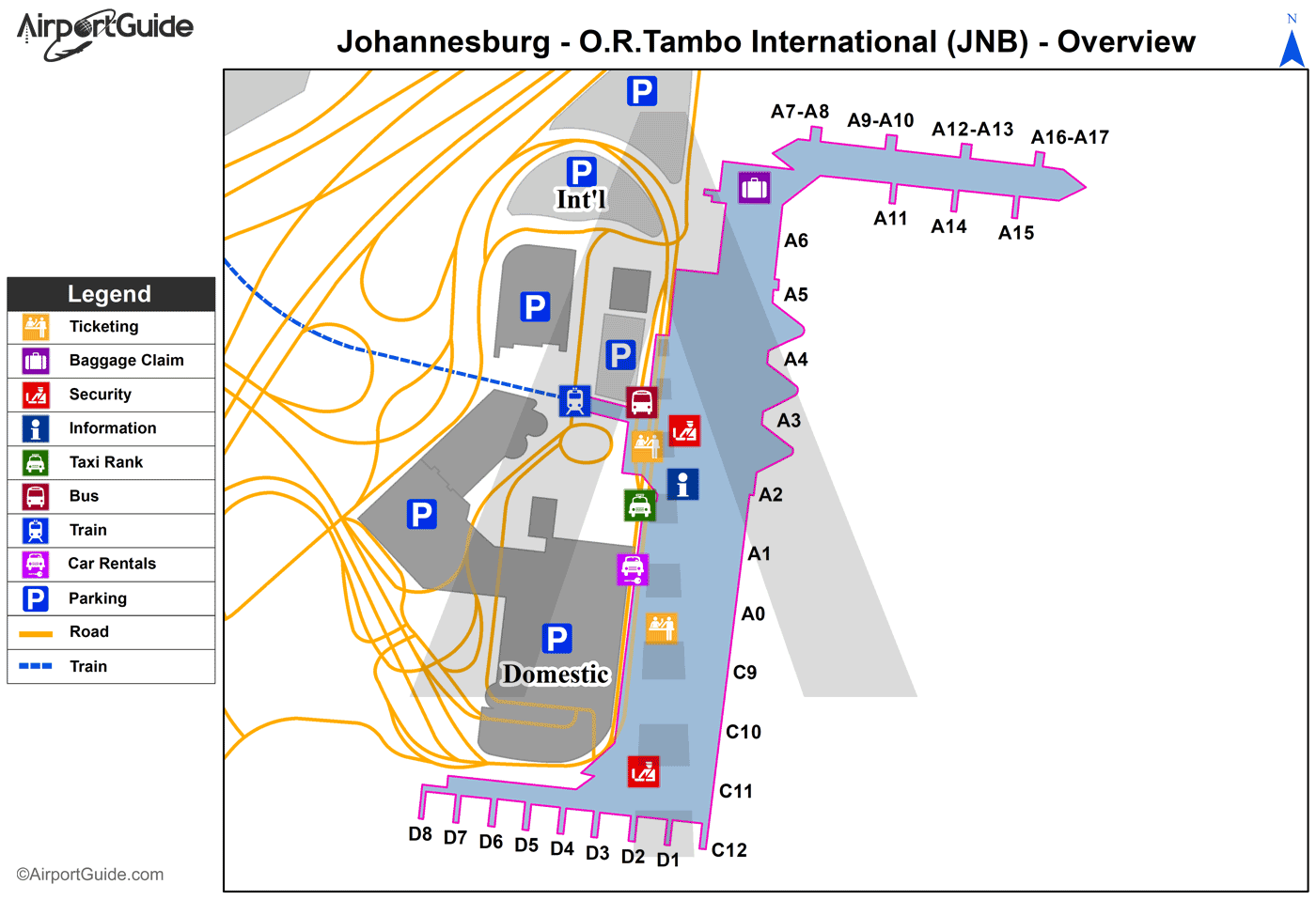
Maps & Diagrams
JNB Sectional
Flight Planning
at skyvector.com
at skyvector.com
