
Location
Latitude: |
50-51-57.2333N (50.865898) |
Longitude: |
007-08-33.8632E (7.14274) |
Elevation: |
302 feet MSL (92 m MSL) |
Magnetic Variation: |
3.1 E (as of April 2024 from WMM2020 model) |
Time Zone: |
UTC +1.0 (Standard Time) UTC +2.0 (Daylight Savings Time) |
Contacts
Manager: |
: |
Operations
Airport Status: |
Operational |
Facility Use: |
Public |
Type: |
Airport |
Traffic Pattern Altitude (MSL): |
1302 feet (397 m) |
Based Aircraft
Annual Operations (as of )
Communications
| TWR: | 124.975 |
| LANGEN INFO: | 129.875 |
| CLNC DEL: | 121.85 |
| GND: | 121.725 |
| APRON: | 121.95 |
| LANGEN RADAR: | 118.75 |
| ATIS: | 132.13 |
| ATIS: | 112.15 |
| DIR: | 121.05 |
| MIL: | 136.25 |
Fixed Based Operators (FBOs) & Fuel
(Click on a business for detail)
Please help us keep this information up to date. This is a FREE SERVICE just like everything else on Airport Guide! If you see that a business needs to be added, modified, or deleted please fill out our Update Form.
To add, modify, or delete a business click here.
Please help us keep this information up to date. This is a FREE SERVICE just like everything else on Airport Guide! If you see that a business needs to be added, modified, or deleted please fill out our Update Form.
| Business Name | Frequency | Phone | Fuel Grade |
|---|
Flight Service Stations
| Primary | Alternate | |
| FSS on Field: | ||
| FSS Name (ID): | ||
| Frequency: | ||
| Toll Free Phone: |
Instrument Procedures / Charts
Terminal Procedures are only available for airports in several countries with more being added all the time. If you are looking for a specific country's charts, please send an email to support(at)airportguide.com stating the country name. This will be used to prioritize the implementation.
Navigation Aids (Navaids) near CGN
| Dist (NM) | ID | Morse Code | Name | Type | Freq | True Hdg | Mag Hdg |
|---|---|---|---|---|---|---|---|
| 0.3 | KBO | Koln/Bonn | VOR-DME | 112.15 | 157 | 154 | |
| 4.6 | LW | Koln/Bonn | NDB | 301 | 64 | 61 | |
| 4.8 | LJ | Koln/Bonn | NDB | 365 | 320 | 317 | |
| 5.2 | LV | Koln/Bonn | NDB | 327 | 135 | 132 | |
| 12.1 | WYP | Wipper | VOR | 109.60 | 25 | 22 | |
| 17.8 | COL | Cola | VORTAC | 108.80 | 105 | 102 | |
| 27.7 | BAM | Barmen | VORTAC | 113.60 | 2 | 359 | |
| 29.0 | DUS | Dusseldorf | VOR-DME | 115.15 | 329 | 326 | |
| 30.4 | LI | Dusseldorf | NDB | 417 | 341 | 338 | |
| 30.6 | NMN | Mendig | NDB | 331 | 167 | 164 | |
| 32.4 | MGB | Monchengladbach | NDB | 377 | 312 | 309 | |
| 33.1 | MHD | Monchengladbach | DME | 112.50 | 312 | 309 | |
| 33.2 | MHV | Monchengladbach | VOR | 109.80 | 312 | 309 | |
| 33.7 | GMH | Germinghausen | VOR-DME | 115.40 | 56 | 53 | |
| 36.8 | SLD | Siegerland | DME | 108.05 | 104 | 101 | |
| 39.4 | SIL | Siegerland | NDB | 489 | 106 | 103 | |
| 41.3 | BUE | Buchel | TACAN | 117.10 | 183 | 180 | |
| 41.4 | LMA | Lima | NDB | 311 | 317 | 314 | |
| 41.9 | GIX | Geilenkirchen | TACAN | 108.10 | 278 | 275 | |
| 43.4 | BOT | Bottrop | NDB | 407 | 354 | 351 |
Nearby Airports with Fuel
| Dist (NM) | Name (Airport IDs) | True Hdg | Mag Hdg | Fuel Grade |
|---|
Notices to Airmen (NOTAMS)
Remarks
No remarks for this landing facility
Runways
Runway Summary
| Runways: | 06/24 14L/32R 14R/32L |
| Longest Runway: | 14L/32R is 12516 ft (3815 m) long |
| Runways with an Instrument Approach: |
CGN Airport Runway Details
| Runway 06/24 | 8067 ft x 148 ft (2459 m x 45 m) | |
| Runway Edge Lights: | Yes Intensity | |
Runway 06 |
Runway 24 |
|
Elevation: |
231 | 272 |
Latitude: |
50.86009979248 | 50.86970138549 |
Longitude: |
7.1237797737121 | 7.1552700996398 |
|
Runway True Alignment: |
64 | 244 |
Glide Path Angle: |
0.0 degrees | 0.0 degrees |
REIL: |
Yes | Yes |
Threshold Elevation: |
231 | 272 |
| Runway 14L/32R | 12516 ft x 197 ft (3815 m x 60 m) | |
| Runway Edge Lights: | Yes Intensity | |
Runway 14L |
Runway 32R |
|
Elevation: |
230 | 302 |
Latitude: |
50.88050079345 | 50.85520172119 |
Longitude: |
7.1290798187255 | 7.1656899452209 |
|
Runway True Alignment: |
137.5 | 317.5 |
Glide Path Angle: |
0.0 degrees | 0.0 degrees |
REIL: |
Yes | Yes |
Threshold Elevation: |
230 | 302 |
| Runway 14R/32L | 6112 ft x 148 ft (1863 m x 45 m) | |
| Runway Edge Lights: | Yes Intensity | |
Runway 14R |
Runway 32L |
|
Elevation: |
221 | 259 |
Latitude: |
50.87080001831 | 50.85850143432 |
Longitude: |
7.1208600997924 | 7.1387400627136 |
|
Runway True Alignment: |
137.5 | 317.5 |
Glide Path Angle: |
0.0 degrees | 0.0 degrees |
REIL: |
Yes | Yes |
Threshold Elevation: |
221 | 259 |
Services
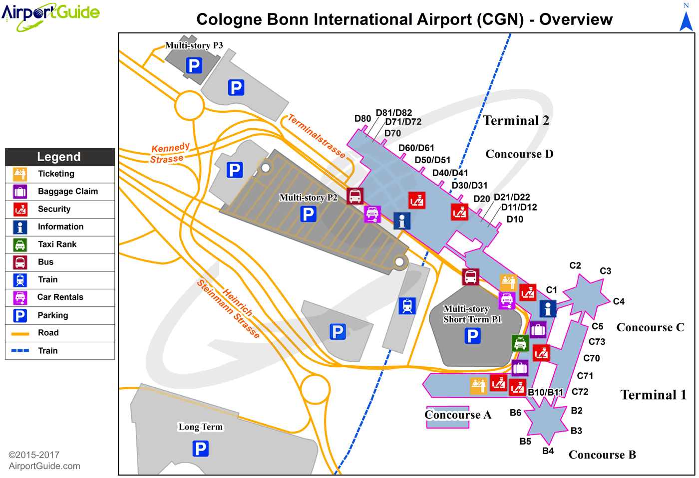
Maps & Diagrams
CGN Sectional
Flight Planning
at skyvector.com
at skyvector.com
