Location
Latitude: |
38-47-26.2000N (38.790611) |
Longitude: |
097-39-08.0000W (-97.652222) |
Elevation: |
1288.0 feet MSL (393 m MSL) |
Magnetic Variation: |
3.3 E (as of April 2024 from WMM2020 model) |
Time Zone: |
UTC -6.0 (Standard Time) UTC -5.0 (Daylight Savings Time) |
From City: |
03 N.M. SW of Salina, Kansas |
Found On: |
Wichita Chart |
FAA Region: |
ACE |
Contacts
Manager: |
Publicly owned: |
| MR. TIMOTHY F ROGERS 3237 ARNOLD AVENUE SALINA, KS 67401 785-827-3914 |
SALINA ARPT AUTH 3237 ARNOLD AVENUE SALINA, KS 67401 785-827-3914 |
Operations
Airport Status: |
Operational |
Facility Use: |
Public |
Type: |
Airport |
Control tower: |
Yes |
Attendance (Months/Days/Hours): |
Months/Days/Hours ALL/ALL/ALL |
Boundary ARTCC: |
ZKC (Kansas City) |
Responsible ARTCC: |
ZKC (Kansas City) |
Lighting Schedule: |
SEE RMK |
Segmented Circle Indicator: |
No |
Traffic Pattern Altitude (MSL): |
2288 feet (697 m) |
NOTAMs Facility: |
SLN |
NOTAM-D Service: |
Yes |
International Airport of Entry: |
No |
Customs Landing Rights: |
No |
Military Landing Rights: |
Yes |
Civil/Military Joint Use: |
No |
Aircraft Rescue and Firefighting: |
Class I ARFF Index: A Air Carrier Service: Scheduled Certification Date: 05/1973 |
Based Aircraft
| Single Engine: | 86 |
| Multi Engine: | 9 |
| Jet Engine: | 13 |
| GA Helicopters: | 4 |
| Gliders: | 3 |
| Military Aircraft: | 5 |
Annual Operations (as of 03/31/2023)
| Total Operations: | 70884 | |
| Commercial: | 1741 | 2.5% |
| Air Taxi: | 21236 | 30.0% |
| GA Local: | 33120 | 46.7% |
| GA Itinerant: | 9332 | 13.2% |
| Military Aircraft: | 5455 | 7.7% |
Communications
| CTAF: | 119.300 |
| Unicom: | 122.950 |
| Tower: | SALINA 119.3 257.7 124.35 Hrs: 0700-2300 |
| Ground: | 121.9 360.8 |
| Approach: | KANSAS CITY ARTCC |
| Departure: | KANSAS CITY ARTCC |
| ATIS: | 120.15 Hrs: 24 |
| ASOS: | 120.15 (785-823-3402) |
| EMERG: | 243.0 |
| NG OPS: | 304.6 |
| NG OPS: | 41.7 |
- APCH/DEP CTL SVC PRVDD BY KANSAS CITY ARTCC (ZKC) ON FREQS 134.9/363.2 (SALINA RCAG).
Fixed Based Operators (FBOs) & Fuel
(Click on a business for detail)
Please help us keep this information up to date. This is a FREE SERVICE just like everything else on Airport Guide! If you see that a business needs to be added, modified, or deleted please fill out our Update Form.
To add, modify, or delete a business click here.
Please help us keep this information up to date. This is a FREE SERVICE just like everything else on Airport Guide! If you see that a business needs to be added, modified, or deleted please fill out our Update Form.
Area Code: 785 |
| Business Name | Frequency | Phone | Fuel Grade |
|---|---|---|---|
| Avflight
Website Update FBO info |
122.95 | 785-825-6739 | 100LL, Jet A |

|
 Avfuel |
100LL - 6.25 USD per gallon on 9/24/14 |
Trucks AvFuel Contract Available |
|
|
Avfuel |
Jet A - 4.66 USD per gallon on 9/24/14 |
Trucks AvFuel Contract Available |
| Moore's Midway Aviation, Inc.
Update FBO info |
Unicom 122.95 | 825-6261, 800-748-8260 | 100LL, Jet A |
Flight Service Stations
| Primary | Alternate | |
| FSS on Field: | N | |
| FSS Name (ID): | Wichita(ICT) | |
| Frequency: | ||
| Toll Free Phone: | 1-800-WX-BRIEF |
Instrument Procedures / Charts
FAA Terminal Procedures valid from 0901Z 03/21/24 to 0901Z 04/18/24.
There are various types of charts available for an airport. They are listed in the Page Type column. Here is a legend for those types:
APD - Airport Diagram
DP - Departure Procedure Charts
HOT - Hot Spots
IAP - Instrument Approach Procedure Charts
MIN - Minimums
STAR - Standard Terminal Arrival Charts
| Page Type | Page Name | Volume | Action Since Last Cycle |
|---|---|---|---|
| APD | AIRPORT DIAGRAM | NC-2 | |
| HOT | HOT SPOT | NC-2 | |
| IAP | ILS OR LOC RWY 35 | NC-2 | |
| IAP | NDB RWY 35 | NC-2 | |
| IAP | RNAV (GPS) RWY 12 | NC-2 | |
| IAP | RNAV (GPS) RWY 17 | NC-2 | |
| IAP | RNAV (GPS) RWY 30 | NC-2 | |
| IAP | RNAV (GPS) RWY 35 | NC-2 | |
| IAP | VOR RWY 17 | NC-2 | |
| MIN | ALTERNATE MINIMUMS | NC-2 | |
| MIN | TAKEOFF MINIMUMS | NC-2 |
Terminal Procedures are only available for airports in several countries with more being added all the time. If you are looking for a specific country's charts, please send an email to support(at)airportguide.com stating the country name. This will be used to prioritize the implementation.
Navigation Aids (Navaids) near SLN
| Dist (NM) | ID | Morse Code | Name | Type | Freq | True Hdg | Mag Hdg |
|---|---|---|---|---|---|---|---|
| 6.6 | SL | . . . . _ . . | Flory | NDB | 344 | 177 | 174 |
| 8.2 | SLN | . . . . _ . . _ . | Salina | VORTAC | 117.10 | 10 | 7 |
| 26.6 | MPR | _ _ . _ _ . . _ . | Mc Pherson | NDB | 227 | 183 | 180 |
| 37.9 | LYO | . _ . . _ . _ _ _ _ _ | Lyons | NDB | 386 | 225 | 222 |
| 38.5 | FRI | . . _ . . _ . . . | Fort Riley | VOR | 109.40 | 73 | 70 |
| 39.8 | HRU | . . . . . _ . . . _ | Herington | NDB | 407 | 98 | 95 |
| 42.0 | HU | . . . . . . _ | Saltt | NDB | 404 | 197 | 194 |
| 42.1 | CYW | _ . _ . _ . _ _ . _ _ | Clay Center | NDB | 362 | 32 | 29 |
| 42.5 | CVY | _ . _ . . . . _ _ . _ _ | Cavalry | NDB | 314 | 70 | 67 |
| 42.6 | CA | _ . _ . . _ | Harvs | NDB | 395 | 155 | 152 |
| 45.8 | CNK | _ . _ . _ . _ . _ | Concordia | NDB | 335 | 0 | 357 |
| 47.1 | EWK | . . _ _ _ . _ | Newton | NDB | 281 | 157 | 154 |
| 49.4 | HUT | . . . . . . _ _ | Hutchinson | VOR-DME | 116.80 | 195 | 192 |
| 50.6 | MHK | _ _ . . . . _ . _ | Manhattan | VOR-DME | 110.20 | 64 | 61 |
| 61.4 | RPB | . _ . . _ _ . _ . . . | Republican | NDB | 414 | 359 | 356 |
| 62.8 | ICT | . . _ . _ . _ | Wichita | VORTAC | 113.80 | 177 | 174 |
| 64.1 | HIL | . . . . . . . _ . . | Hilyn | NDB | 338 | 246 | 242 |
| 65.1 | GB | _ _ . _ . . . | Babsy | NDB | 419 | 240 | 236 |
| 67.2 | TKO | _ _ . _ _ _ _ | Mankato | VORTAC | 109.80 | 335 | 332 |
| 70.0 | ICT | . . _ . _ . _ | Wichita | VOT | 114.00 | 171 | 168 |
Nearby Airports with Fuel
Notices to Airmen (NOTAMS)
Remarks
| A110-10 | SVC: FLUID- LPOX, HPOX, LPNIT, LOX (72HR NOTICE) DEICING SERVICE TYPE 1& TYPE 4 OIL 0-128-148 AVBL IN QUART CANS TRANS SVC AVBL AT FBO. LOGISTICAL SVC AVBL FOR DETS AND RON AT FBO (AVFLIGHT SALINA, 785-825-6739/CELL 785-819-2236.) |
| A110-11 | ARNG: RAMP SPACE AVBL TO ACCOMMODATE UP TO 80 FIGHTERS. SMOKY HILL ANG WEAPONS RANGE 16 NM TO THE SW. COORD RANGE TIME AT DSN 743-7600 EXT 148. MILITARY BILLETING AVAILABLE 888-577-8257. LOGISTIC EQPT AVBL FOR USE. ORDNANCE STORAGE FOR CLASS 1.3 THRU 1.4. |
| A110-12 | ARNG: TSNT ARMY ACFT CTC SALINA GUARD OPS ON 229.80 OR 34.10 SC RED. LIMITED UH-60 SVC AND MAINT AVBL. |
| A110-13 | 100LL SELF SVC FUELING STN LOCATED SOUTH OF KANSAS ANG. |
| A110-14 | GND SUPPORT AND LOGISTICS EQUIP AVBL INCL TUGS, BOBTAILS, TOW BARS AND AIRSTAIRS. |
| A110-15 | RY 04/22 AND RY 18-36 UNAVBL FOR USE BY ACR WITH MORE THAN 9 PSGR SEATS. |
| A110-16 | H1 INGRESS/EGRESS 070 DEG THROUGH 040 DEG TO AVOID CTL TWR. |
| A110-17 | ALL HELIPADS DALGT USE ONLY. |
| A110-18 | H3, H4, H5, H6 USED EXTSVLY FOR TRNG. |
| A110-19 | H2, H3 LTD TO 6,000 LBS; H4, H5 LTD TO 25,000 LBS. |
| A110-2 | NO LINE OF SIGHT, ALL RYS DUE TO GRADIENT, TOPOGRAPHY & TREES. |
| A110-20 | NOISE ABATEMENT: HEAVY & MIL ACFT TPA AT 2,800 MSL OR ABOVE. |
| A110-21 | FOR CD IF UNA TO CTC ON FSS FREQ, CTC KANSAS CITY ARTCC AT 913-254-8508. |
| A110-22 | BTN 0001-0459L ACR OPNS INVOLVING ACFT WITH MORE THAN 9 PSGRS SEATS ARE NOT AUTH IN EXCESS OF 15 MINS BFR OR AFT SKED ARR OR DEP TIMES WO PRIOR COORD WITH AMGR TO CFM THAT ARFF SVCS ARE AVBL PRIOR TO LNDG OR TKOF. CALL AMGR 785-827-3914. |
| A110-5 | SEASONAL MOWING OPNS ADJ TO RYS & TWYS. |
| A110-6 | CALM WND RY 35. |
| A110-8 | ARNG: OPR 1300-2300Z++ TUE-FRI; OCNL SAT EXC HOL. LTD MAINT UH-60. ARNG, AR AND A CTC ARNG OPS PRIOR TO LDG OR CALL 785 827 3914 FOR LIASON. |
| A110-9 | SVC: JASU- 2(A/M32-95) 2(A/M32-60B) 1(A/M32-86D). |
| A26 | RWY 4/22 & RWY 18/36 NOT AVBL FOR SCHEDULED ACR OPNS WITH MORE THAN 9 PSGR SEATS OR UNSCHEDULED ACR AT LEAST 31 PSGR SEATS |
| A26 1 | PPR 24 HRS FOR UNSKED ACR OPNS WITH MORE THAN 30 PSGR SEATS CALL AMGR 785-827-3914. ARFF INDEX B PROVDD SUN-SAT 0600 TO 2200 (LOCAL). INDEX E AVBL UPON REQ. |
| A81-APT | WHEN ATCT CLSD ACTVT MIRL RY 12/30; PAPI RYS 12 & 30; HIRL RY 17/35; MALS & PAPI RYS 17 & 35; MALSR RY 35 - CTAF. |
Runways
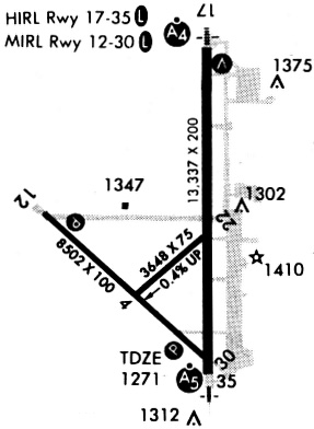
Runway Summary
| Runways: | 04/22 12/30 17/35 18/36 H1 H2 H3 H4 H5 H6 |
| Longest Runway: | 17/35 is 12301 ft (3749 m) long |
| Runways with an Instrument Approach: | 35 |
SLN Airport Runway Details
| Runway 04/22 | 3648 ft x 75 ft (1112 m x 23 m) | |
| Runway Length Source: | 3RD PARTY SURVEY as of 02/20/2011 | |
| Surface: | Asphalt - Good condition - No special surface treatment | |
| Runway Pavement Class: | 5 /F/C/Y/U | |
Runway Weight Bearing Capacity (in thousands of pounds) |
||
| Single Wheel Landing Gear: | 100.0 | |
| Dual Wheel Landing Gear: | 135.0 | |
| Dual Tandem Wheel Landing Gear: | 230.0 | |
Runway 04 |
Runway 22 |
|
Elevation: |
1270.7 | 1256.0 |
Latitude: |
38-47-10.2887N | 38-47-33.9969N |
Longitude: |
097-39-22.1203W | 097-38-47.4153W |
|
Runway True Alignment: |
049 | 229 |
Glide Path Angle: |
0.0 degrees | 0.0 degrees |
Traffic Pattern: |
Left | Left |
Runway Markings Type: |
Basic | Basic |
Runway Markings Condition: |
Fair | Fair |
Object at End: |
BLDG | |
Object Height: |
46 | |
Object Marked/Lighted?: |
Lighted | |
Distance from End: |
1550 | |
Object Centerline Offset: |
200 ft. left of centerline | |
Declared Distances |
||
Take Off Run Avbl. (TORA): |
3648 | 3648 |
Take Off Distance Avbl. (TODA): |
3648 | 3648 |
Actual Stop Dist. Avbl. (ASDA): |
3648 | 3648 |
Landing Dist. Avbl. (LDA): |
3648 | 3648 |
| Runway 12/30 | 6510 ft x 100 ft (1984 m x 30 m) | |
| Runway Length Source: | 3RD PARTY SURVEY as of 02/20/2011 | |
| Surface: | Asphalt - Good condition - No special surface treatment | |
| Runway Pavement Class: | 23 /R/C/X/U | |
| Runway Edge Lights: | Medium Intensity | |
Runway Weight Bearing Capacity (in thousands of pounds) |
||
| Single Wheel Landing Gear: | 55.0 | |
| Dual Wheel Landing Gear: | 68.0 | |
| Dual Tandem Wheel Landing Gear: | 125.0 | |
Runway 12 |
Runway 30 |
|
Elevation: |
1258.3 | 1271.7 |
Latitude: |
38-47-36.8844N | 38-46-53.5059N |
Longitude: |
097-40-01.1155W | 097-39-00.3925W |
|
Runway True Alignment: |
132 | 312 |
Glide Path Angle: |
3.0 degrees | 3.0 degrees |
Traffic Pattern: |
Left | Left |
Runway Markings Type: |
Nonprecision Instrument | Nonprecision Instrument |
Runway Markings Condition: |
Good | Good |
Object Centerline Offset: |
200 ft. left of centerline | |
Visual Glide Slope Indicators: |
4-Light PAPI On Left Side Of Runway | 4-Light PAPI On Left Side Of Runway |
Threshold Crossing Height: |
45 | 45 |
Declared Distances |
||
Take Off Run Avbl. (TORA): |
6510 | 6510 |
Take Off Distance Avbl. (TODA): |
6510 | 6510 |
Actual Stop Dist. Avbl. (ASDA): |
6510 | 6510 |
Landing Dist. Avbl. (LDA): |
6510 | 6510 |
| Runway 17/35 | 12301 ft x 150 ft (3749 m x 46 m) | |
| Runway Length Source: | 3RD PARTY SURVEY as of 10/15/2013 | |
| Surface: | Asphalt - Good condition - No special surface treatment | |
| Runway Pavement Class: | 75 /R/C/W/U | |
| Runway Edge Lights: | High Intensity | |
Runway Weight Bearing Capacity (in thousands of pounds) |
||
| Single Wheel Landing Gear: | 75.0 | |
| Dual Wheel Landing Gear: | 200.0 | |
| Dual Tandem Wheel Landing Gear: | 360.0 | |
| Dual Dual Tandem Wheel Landing Gear: | 600.0 | |
Runway 17 |
Runway 35 |
|
Elevation: |
1245.8 | 1271.1 |
Latitude: |
38-48-37.4728N | 38-46-35.8980N |
Longitude: |
097-38-45.4540W | 097-38-45.1485W |
|
Runway True Alignment: |
180 | 360 |
ILS Type: |
ILS | |
Glide Path Angle: |
3.0 degrees | 3.0 degrees |
Traffic Pattern: |
Left | Left |
Runway Markings Type: |
Precision Instrument | Precision Instrument |
Runway Markings Condition: |
Good | Good |
Object at End: |
GND | |
Object Height: |
30 | |
Distance from End: |
1375 | |
Object Centerline Offset: |
200 ft. left of centerline | |
Visual Glide Slope Indicators: |
4-Light PAPI On Left Side Of Runway | 4-Light PAPI On Right Side Of Runway |
Approach Light System: |
1,400 Foot Medium Intensity Approach Lighting System | 1,400 Foot Medium Intensity Approach Lighting System With Runway Alignment Indicator Lights |
Threshold Crossing Height: |
52 | 48 |
Declared Distances |
||
Take Off Run Avbl. (TORA): |
12300 | 12300 |
Take Off Distance Avbl. (TODA): |
12300 | 12300 |
Actual Stop Dist. Avbl. (ASDA): |
12300 | 12300 |
Landing Dist. Avbl. (LDA): |
12300 | 12300 |
| Runway 18/36 | 4301 ft x 75 ft (1311 m x 23 m) | |
| Runway Length Source: | 3RD PARTY SURVEY as of 02/20/2011 | |
| Surface: | Asphalt - Good condition - No special surface treatment | |
| Runway Pavement Class: | 11 /F/C/Y/U | |
Runway Weight Bearing Capacity (in thousands of pounds) |
||
| Single Wheel Landing Gear: | 30.0 | |
Runway 18 |
Runway 36 |
|
Elevation: |
1253.7 | 1287.8 |
Latitude: |
38-47-37.7301N | 38-46-55.2220N |
Longitude: |
097-39-41.2872W | 097-39-41.1755W |
|
Runway True Alignment: |
180 | 360 |
Glide Path Angle: |
0.0 degrees | 0.0 degrees |
Runway Markings Type: |
Nonprecision Instrument | Nonprecision Instrument |
Runway Markings Condition: |
Good | Good |
Object Centerline Offset: |
200 ft. left of centerline | |
Declared Distances |
||
Take Off Run Avbl. (TORA): |
4300 | 4300 |
Take Off Distance Avbl. (TODA): |
4300 | 4300 |
Actual Stop Dist. Avbl. (ASDA): |
4300 | 4300 |
Landing Dist. Avbl. (LDA): |
4300 | 4300 |
| Helipad H1 | 57 ft x 57 ft (17 m x 17 m) | |
| Runway Length Source: | OWNER as of 06/24/2010 | |
| Surface: | Asphalt - Good condition - No special surface treatment | |
Helipad H1 |
||
Elevation: |
1260.0 | |
Latitude: |
38-47-18.6400N | |
Longitude: |
097-38-35.0600W | |
Glide Path Angle: |
0.0 degrees | 0.0 degrees |
Object Centerline Offset: |
200 ft. left of centerline |
| Helipad H2 | 29 ft x 28 ft (9 m x 9 m) | |
| Runway Length Source: | OWNER as of 06/24/2010 | |
| Surface: | Asphalt - Good condition - No special surface treatment | |
Helipad H2 |
||
Elevation: |
1260.0 | |
Latitude: |
38-47-50.5400N | |
Longitude: |
097-38-38.3100W | |
Glide Path Angle: |
0.0 degrees | 0.0 degrees |
Object Centerline Offset: |
200 ft. left of centerline |
| Helipad H3 | 30 ft x 30 ft (9 m x 9 m) | |
| Runway Length Source: | OWNER as of 06/24/2010 | |
| Surface: | Asphalt - Good condition - No special surface treatment | |
Helipad H3 |
||
Elevation: |
1250.0 | |
Latitude: |
38-47-46.8100N | |
Longitude: |
097-39-08.1900W | |
Glide Path Angle: |
0.0 degrees | 0.0 degrees |
Object Centerline Offset: |
200 ft. left of centerline |
| Helipad H4 | 57 ft x 43 ft (17 m x 13 m) | |
| Runway Length Source: | OWNER as of 06/24/2010 | |
| Surface: | Asphalt - Good condition - No special surface treatment | |
Helipad H4 |
||
Elevation: |
1253.0 | |
Latitude: |
38-47-37.2900N | |
Longitude: |
097-39-17.0200W | |
Glide Path Angle: |
0.0 degrees | 0.0 degrees |
Object Centerline Offset: |
200 ft. left of centerline |
| Helipad H5 | 57 ft x 57 ft (17 m x 17 m) | |
| Runway Length Source: | OWNER as of 06/24/2010 | |
| Surface: | Asphalt - Good condition - No special surface treatment | |
Helipad H5 |
||
Elevation: |
1250.0 | |
Latitude: |
38-47-46.9300N | |
Longitude: |
097-39-25.8100W | |
Glide Path Angle: |
0.0 degrees | 0.0 degrees |
Object Centerline Offset: |
200 ft. left of centerline |
| Helipad H6 | 29 ft x 29 ft (9 m x 9 m) | |
| Runway Length Source: | OWNER as of 06/24/2010 | |
| Surface: | Asphalt - Good condition - No special surface treatment | |
Helipad H6 |
||
Elevation: |
1253.0 | |
Latitude: |
38-47-00.4400N | |
Longitude: |
097-39-25.9900W | |
Glide Path Angle: |
0.0 degrees | 0.0 degrees |
Object Centerline Offset: |
200 ft. left of centerline |
Services
Airframe Repair: |
Major |
Powerplant Repair: |
Major |
Bottled Oxygen: |
High Pressure / Low Pressure |
Bulk Oxygen: |
High Pressure / Low Pressure |
Fuel Available: |
100LL, Jet A |
Landing Fees: |
No |
Parking: |
Hangars and tiedowns available |
Maps & Diagrams
SLN Sectional
Flight Planning
at skyvector.com
at skyvector.com