
Location
Latitude: |
60-11-38.0438N (60.193901) |
Longitude: |
011-06-01.4399E (11.1004) |
Elevation: |
681 feet MSL (208 m MSL) |
Magnetic Variation: |
4.8 E (as of April 2024 from WMM2020 model) |
Time Zone: |
UTC +1.0 (Standard Time) UTC +2.0 (Daylight Savings Time) |
Contacts
Manager: |
: |
Operations
Airport Status: |
Operational |
Facility Use: |
Public |
Type: |
Airport |
Traffic Pattern Altitude (MSL): |
1681 feet (512 m) |
Based Aircraft
Annual Operations (as of )
Communications
| TWR: | 118.3 |
| CLNC DEL: | 121.6 |
| GND: | 121.925 |
| APP: | 119.975 |
| ATIS: | 126.125 |
| DIRECTOR: | 131.35 |
| DE ICING: | 131.975 |
| WINGOPS: | 29.38 |
| PMSV METRO: | 134.175 |
Fixed Based Operators (FBOs) & Fuel
(Click on a business for detail)
Please help us keep this information up to date. This is a FREE SERVICE just like everything else on Airport Guide! If you see that a business needs to be added, modified, or deleted please fill out our Update Form.
To add, modify, or delete a business click here.
Please help us keep this information up to date. This is a FREE SERVICE just like everything else on Airport Guide! If you see that a business needs to be added, modified, or deleted please fill out our Update Form.
| Business Name | Frequency | Phone | Fuel Grade |
|---|
Flight Service Stations
| Primary | Alternate | |
| FSS on Field: | ||
| FSS Name (ID): | ||
| Frequency: | ||
| Toll Free Phone: |
Instrument Procedures / Charts
Terminal Procedures are only available for airports in several countries with more being added all the time. If you are looking for a specific country's charts, please send an email to support(at)airportguide.com stating the country name. This will be used to prioritize the implementation.
Navigation Aids (Navaids) near OSL
| Dist (NM) | ID | Morse Code | Name | Type | Freq | True Hdg | Mag Hdg |
|---|---|---|---|---|---|---|---|
| 0.8 | GRM | Gardermoen | VOR-DME | 115.95 | 260 | 255 | |
| 11.5 | SLB | Solberg | NDB | 414 | 199 | 194 | |
| 12.5 | OPA | Oppaker | NDB | 334 | 86 | 81 | |
| 21.3 | BGU | Bergerud | NDB | 316 | 166 | 161 | |
| 28.1 | BBU | Brandbu | VOR-DME | 112.75 | 306 | 301 | |
| 29.5 | TRF | Tyrifjord | NDB | 352 | 237 | 232 | |
| 35.4 | SOK | Soknen | NDB | 387 | 274 | 269 | |
| 37.4 | HAA | Hamar | NDB | 371 | 358 | 353 | |
| 40.5 | DRA | Drammen | VOR-DME | 114.80 | 227 | 222 | |
| 45.3 | SIG | Sigdal | VOR-DME | 117.70 | 256 | 252 | |
| 49.8 | RYG | Rygge | TACAN | 113.50 | 191 | 186 | |
| 50.2 | YG | Enge | NDB | 396 | 189 | 184 | |
| 52.2 | RG | Tune | NDB | 381 | 183 | 178 | |
| 56.0 | MES | Mesnali | VOR-DME | 114.40 | 346 | 341 | |
| 61.5 | DA | Dalen | NDB | 404 | 204 | 199 | |
| 66.6 | TOR | Torp | VOR-DME | 113.85 | 202 | 197 | |
| 69.2 | NTD | Notodden | NDB | 400 | 239 | 235 | |
| 70.1 | SF | Sandefjord | NDB | 283 | 201 | 196 | |
| 72.2 | HE | Heddal | NDB | 324 | 241 | 237 | |
| 72.2 | MR | Myra | NDB | 389 | 220 | 216 |
Nearby Airports with Fuel
| Dist (NM) | Name (Airport IDs) | True Hdg | Mag Hdg | Fuel Grade |
|---|
Notices to Airmen (NOTAMS)
Remarks
No remarks for this landing facility
Runways
Runway Summary
| Runways: | 01L/19R 01R/19L |
| Longest Runway: | 01L/19R is 11811 ft (3600 m) long |
| Runways with an Instrument Approach: |
OSL Airport Runway Details
| Runway 01L/19R | 11811 ft x 148 ft (3600 m x 45 m) | |
| Runway Edge Lights: | Yes Intensity | |
Runway 01L |
Runway 19R |
|
Elevation: |
656 | 675 |
Latitude: |
60.18500137329 | 60.21609878540 |
Longitude: |
11.073699951171 | 11.091699600219 |
|
Runway True Alignment: |
16 | 196 |
Glide Path Angle: |
0.0 degrees | 0.0 degrees |
REIL: |
Yes | Yes |
Threshold Elevation: |
656 | 675 |
| Runway 01R/19L | 9678 ft x 148 ft (2950 m x 45 m) | |
| Runway Edge Lights: | Yes Intensity | |
Runway 01R |
Runway 19L |
|
Elevation: |
670 | 681 |
Latitude: |
60.17580032348 | 60.20119857788 |
Longitude: |
11.107799530029 | 11.122500419616 |
|
Runway True Alignment: |
16 | 196 |
Glide Path Angle: |
0.0 degrees | 0.0 degrees |
REIL: |
Yes | Yes |
Threshold Elevation: |
670 | 681 |
Services
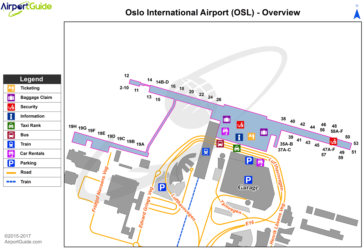
Maps & Diagrams
OSL Sectional
Flight Planning
at skyvector.com
at skyvector.com
