Location
Latitude: |
60-28-09.0150N (60.469171) |
Longitude: |
164-42-14.5350W (-164.704038) |
Elevation: |
7.1 feet MSL (2 m MSL) |
Magnetic Variation: |
8.5 E (as of April 2024 from WMM2020 model) |
Time Zone: |
UTC -9.0 (Standard Time) UTC -8.0 (Daylight Savings Time) |
From City: |
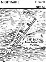
01 N.M. N of Nightmute, Alaska |
Found On: |
Bethel Chart |
FAA Region: |
AAL |
Contacts
Manager: |
Publicly owned: |
| JOSEPH LARAUX BOX 505 BETHEL, AK 99559 (907) 543-2498 |
ALASKA DOT&PF CENTRAL REGION PO BOX 196900 ANCHORAGE, AK 99519-6900 (907) 269-0749 |
Operations
Airport Status: |
Operational |
Facility Use: |
Public |
Type: |
Airport |
Activation Date: |
07/1979 |
Control tower: |
No |
Attendance (Months/Days/Hours): |
Months/Days/Hours Unattended |
Boundary ARTCC: |
ZAN (Anchorage) |
Responsible ARTCC: |
ZAN (Anchorage) |
Lighting Schedule: |
SEE RMK |
Segmented Circle Indicator: |
Yes |
Traffic Pattern Altitude (MSL): |
1007 feet (307 m) |
NOTAMs Facility: |
ENA |
NOTAM-D Service: |
Yes |
Military Landing Rights: |
Yes |
Based Aircraft
Annual Operations (as of 12/31/2022)
| Total Operations: | 300 | |
| Air Taxi: | 300 | 100.0% |
Communications
| CTAF: | 122.900 |
Fixed Based Operators (FBOs) & Fuel
(Click on a business for detail)
Please help us keep this information up to date. This is a FREE SERVICE just like everything else on Airport Guide! If you see that a business needs to be added, modified, or deleted please fill out our Update Form.
To add, modify, or delete a business click here.
Please help us keep this information up to date. This is a FREE SERVICE just like everything else on Airport Guide! If you see that a business needs to be added, modified, or deleted please fill out our Update Form.
Area Code: 907 |
| Business Name | Frequency | Phone | Fuel Grade |
|---|
Flight Service Stations
| Primary | Alternate | |
| FSS on Field: | N | |
| FSS Name (ID): | Kenai(ENA) | |
| Frequency: | ||
| Toll Free Phone: | 1-866-864-1737 |
Instrument Procedures / Charts
Terminal Procedures are only available for airports in several countries with more being added all the time. If you are looking for a specific country's charts, please send an email to support(at)airportguide.com stating the country name. This will be used to prioritize the implementation.
Navigation Aids (Navaids) near NME
| Dist (NM) | ID | Morse Code | Name | Type | Freq | True Hdg | Mag Hdg |
|---|---|---|---|---|---|---|---|
| 45.0 | AIX | . _ . . _ . . _ | Nanwak | NDB-DME | 323 | 264 | 256 |
| 75.3 | HPB | . . . . . _ _ . _ . . . | Hooper Bay | VOR-DME | 115.20 | 327 | 319 |
| 85.5 | OSE | _ _ _ . . . . | Oscarville | NDB | 251 | 75 | 66 |
| 86.8 | BET | _ . . . . _ | Bethel | VORTAC | 114.10 | 76 | 67 |
| 87.3 | CZF | _ . _ . _ _ . . . . _ . | Cape Romanzof | NDB | 275 | 335 | 327 |
| 87.5 | CZF | _ . _ . _ _ . . . . _ . | Cape Romanzof | DME | 116.75 | 334 | 326 |
Nearby Airports with Fuel
| Dist (NM) | Name (Airport IDs) | True Hdg | Mag Hdg | Fuel Grade |
|---|---|---|---|---|
| 86.4 | Bethel Airport (BET PABE BET) |
76 | 66 | 100, 100LL, Jet A, Jet A-1 |
| 95.6 | Quinhagak Airport (KWN PAQH AQH) |
115 | 105 | 100LL |
Notices to Airmen (NOTAMS)
Remarks
| A110-1 | RY COND NOT MONITORED; RECOMMEND VISUAL INSPECTION PRIOR TO USING. |
| A110-2 | BIRD ACTIVITY INVOF ARPT. |
| A110-3 | RWY SURFACE IS SOFT GRAVEL, CAUTION SURFACE CAN BE VERY SOFT WHEN WET. LOOSE GRAVEL ALONG RWY EDGE CAN BE VERY SOFT. |
| A33-03/21 | DIPS IN RY SURFACE; IRREGULAR SURFACES FULL LENGTH. |
| A42-03 | RY 03/21 NSTD MKGS: RY MKD WITH REFLECTIVE CONES AND FLEXIBLE MARKERS. |
| A81-APT | ACTVT MIRL RWY 03/21 - CTAF. |
| A81-BCN | ACTVT ROTG BCN - CTAF. |
Runways
Runway Summary
| Runways: | 03/21 |
| Longest Runway: | 03/21 is 3200 ft (975 m) long |
| Runways with an Instrument Approach: |
NME Airport Runway Details
| Runway 03/21 | 3200 ft x 75 ft (975 m x 23 m) | |
| Runway Length Source: | FAA-EST as of 08/12/2014 | |
| Surface: | Gravel/Dirt - Fair condition - No special surface treatment | |
| Runway Edge Lights: | Medium Intensity | |
Runway 03 |
Runway 21 |
|
Elevation: |
7.0 | 6.2 |
Latitude: |
60-27-56.9900N | 60-28-21.0500N |
Longitude: |
164-42-35.1500W | 164-41-53.9200W |
|
Runway True Alignment: |
040 | 220 |
Glide Path Angle: |
0.0 degrees | 0.0 degrees |
Runway Markings Type: |
Nonstandard (other than numbers only) | Nonstandard (other than numbers only) |
Runway Markings Condition: |
Good | Good |
Object at End: |
BRUSH | |
Object Height: |
5 | |
Distance from End: |
45 | |
Object Centerline Offset: |
70 ft. left and right of centerline | |
REIL: |
No | No |
Services
Fuel Available: |
100LL |
Landing Fees: |
Yes |
Parking: |
Tiedowns available |
Maps & Diagrams
NME Sectional
Flight Planning
at skyvector.com
at skyvector.com